25th Annual Black Diamond Fall Fundraising Party
Thursday, September 13; 6:00-10:00 PM; Black Diamond Parking Lot
25th Annual Black Diamond Fall Fundraising Party
Thursday, September 13; 6:00-10:00 PM; Black Diamond Parking Lot
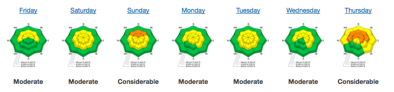
| Advisory: Salt Lake Area Mountains | Issued by Drew Hardesty for Sunday - January 28, 2018 - 6:23am |
|---|

|
bottom line A scary MODERATE danger exists in the mid and upper elevation west to north to easterly facing slopes. Human triggered avalanches 1-3'+ deep remain possible in this terrain. Evaluate snow and terrain carefully. A MODERATE danger also exists for fresh wind drifts along the higher elevations. The safest and arguably best riding conditions can be found on the shady, sheltered terrain on low angle slopes with no overhead hazard.
|
 |
special announcement We have discount lift tickets for Alta, Snowbird, Brighton, Solitude, Snowbasin,and Beaver Mountain. Details and order information here. All proceeds from these go towards paying for avalanche forecasting and education! |
 |
current conditions Skies are overcast - obscured, really - with very light snow falling across the range. With the warm front, mountain temperatures are 15-25 degrees warmer than they were yesterday morning. Ridgeop temps are in the upper teens to low 20s; trailheads are near 30°F. As foretold, the winds veered west northwesterly and increased overnight, particularly along the highest elevations, where they blow 40-45mph with gusts to 60. Four star riding conditions exist on the wind and sun-sheltered slopes with general coverage of 50-70" on the ground in the higher terrain. Be sure to read our Week in Review highlighting avalanche activity and snowfall from this past week.
|
 |
recent activity
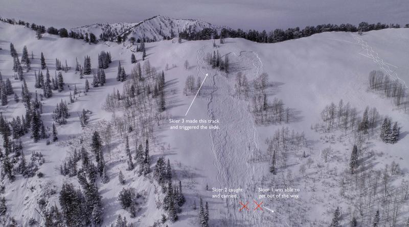
Mark Staples, Trent Meisenheimer, and Mark White have the final accident report here from Friday's avalanche incident in the Meadow Chutes of Silver Fork (BCC). It's a complicated event, but in a nutshell, one skier waiting mid-way down the slope was engulfed by a remotely triggered avalanche from above and subsequently carried over 600' down the slope. Fortunately he was not buried, but suffered injury. Stabilization was provided by his partners (one an ER doc) with evacuation shouldered by Solitude ski patrol, Wasatch Backcountry Rescue, and Intermountain Life Flight. Below is Trent's standard Banff-worthy video production as usual. Video on our YouTube channel here. No avalanche activity reported yesterday from the backcountry or at the resorts, however, in the past week alone, we've had three very close calls in the central Wasatch - two along the Park City ridgeline (No Name and Pointy Peak) and Friday's accident just "right across the street" of Big Cottonwood Canyon in Silver Fork. These three persistent slab avalanches were all east to northeast facing between 9300' and 9600' with skiers taking rides hundreds of feet down the slope. Comprehensive list here. |
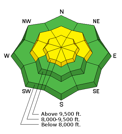
| type | aspect/elevation | characteristics |
|---|

|

|
LIKELIHOOD
 LIKELY
UNLIKELY
SIZE
 LARGE
SMALL
TREND
 INCREASING DANGER
SAME
DECREASING DANGER
|
|
description
Our persistent slab problem isn't going to heal overnight. And even if stability slowly increases over time, these avalanches may continue to spring out of dormancy with each subsequent loading event. These avalanches are insidious: they continue to occur with many tracks already on the slope, with no signs of cracking or collapsing, and each often triggered from a distance. Look at the photos of the Meadow Chutes accident. You'll see days-old tracks into the crown. Note that it was their 6th run in the terrain. The avalanche itself was triggered from a distance - the skier wasn't even on that particular piece of snow that fractured. It's why expert intution is impossible with these types of avalanches and even the most experienced practitioners are surprised. It reminds me of 2010 when many very experienced people were caught off-guard (myself included) by a similar snowpack structure - with in particular a fatality nearly eight years ago to the day in the Meadow Chutes of Silver Fork. |
| type | aspect/elevation | characteristics |
|---|

|

|
LIKELIHOOD
LIKELY
UNLIKELY
SIZE
 LARGE
SMALL
TREND
INCREASING DANGER
SAME
DECREASING DANGER
|
|
description
Thick and dense wind drifts may be found along the higher elevations, but perhaps further down the slope than expected. They'll be more pronounced on steep north to southeast facing slopes and even cross-loaded onto steep southwest and southerly aspects. Look for rounded, pillowy features around rocky outcrops, beyond subridges into adjacent gullies, and in the lee of other terrain features. |
 |
weather We'll see a trace to an inch of snow with riming possible. Winds should lose some steam over the course of the day as the skies trend party cloudy by afternoon. Temps will be in the mid 20s, marching toward the low 30s (even at ridgetop level) by tomorrow. Tomorrow should be partly cloudy, warm, with light wind. Looking down the road, the ridge of high pressure retrogrades west and amplifiies, keeping us under an unsettled and cool northwest flow through the week. Possible snow for next weekend. |
| general announcements CLICK HERE FOR MORE GENERAL INFO AND FAQ The UAC has new support programs with Outdoor Research and Darn Tough. Support the UAC through your daily shopping. When you shop at Smith's, or online at Outdoor Research, REI, Backcountry.com, Darn Tough, Patagonia, NRS, Amazon, eBay a portion of your purchase will be donated to the FUAC. See our Donate Page for more details on how you can support the UAC when you shop. Benefit the Utah Avalanche Center when you buy or sell on eBay - set the Utah Avalanche Center as a favorite non-profit in your eBay account here and click on eBay gives when you buy or sell. You can choose to have your seller fees donated to the UAC, which doesn't cost you a penny This information does not apply to developed ski areas or highways where avalanche control is normally done. This advisory is from the U.S.D.A. Forest Service, which is solely responsible for its content. This advisory describes general avalanche conditions and local variations always occur. |