25th Annual Black Diamond Fall Fundraising Party
Thursday, September 13; 6:00-10:00 PM; Black Diamond Parking Lot
25th Annual Black Diamond Fall Fundraising Party
Thursday, September 13; 6:00-10:00 PM; Black Diamond Parking Lot
| Advisory: Salt Lake Area Mountains | Issued by Drew Hardesty for Sunday - January 21, 2018 - 5:52am |
|---|

|
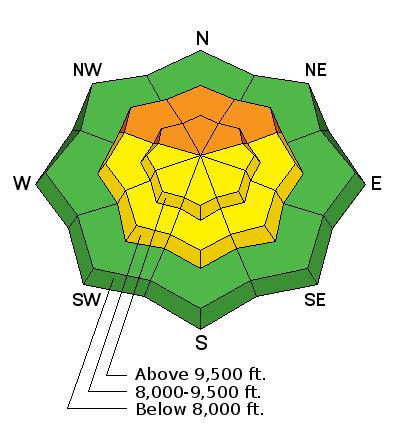
bottom line A CONSIDERABLE danger exists for human triggered slides up to 3' deep. New wind drifts and loose snow avalanches add complexity to the overall picture and are possible on many aspects and elevations. The more unpredictable and potential deadly slides live predominantly on the northwest to northeast facing slopes above about 9000'. High uncertainty requires a high margin for error. Hot Tip! Again, terrain is your friend. The safest and arguably best riding conditions can be found on the low angle southerly slopes with no overhead hazard.
|
 |
special announcement Episode 3 of the UAC podcast went live last night. We talk with UDOT Avalanche Program Supervisor Bill Nalli on how he and his teams keep the Greatest Snow on Earth from avalanching over the open roads and highways of the state. Find it on our blog site (linked above), iTunes, Stitcher, or wherever you get your podcasts. Do you know the parable of the Scorpion and the Frog? A short piece of fiction from Mineral Fork here. |
 |
current conditions It's the stuff that dreams are made of. 12-20" of right-side-up blower powder, capped off by a few inches of 3% density wild snow. The Wasatch will be in all its glory this afternoon with breaking skies, slowing winds, and arguably "best of the year" conditions. I suspect that future cover shots of all the Powder magazines will have a time stamp of Sunday, January 21st. Currently skies are overcast with very light snow falling, the last few flakes of cold smoke from the departing storm. Northwest winds are blowing 15mph with gusts to 30. The most exposed anemometers hum at 20-25mph with gusts to 40. Mountain temperatures have plummeted to the single digits. Now the numbers: (snow/snow water equivalent).
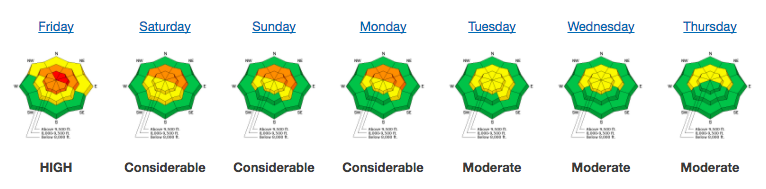
Reading our Week in Review will be worthwhile as you are planning your weekend. Each Friday, Greg Gagne summarizes mountain weather and avalanche activity, as well as archived forecasts and danger roses for the past week. Make it a regular part of your Fridays.
|
 |
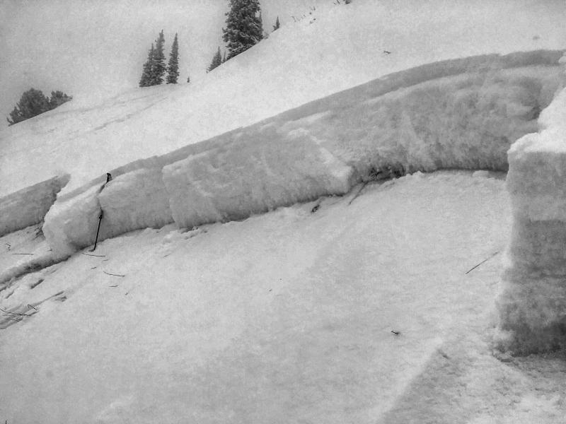
recent activity It's also what fuels nightmares. The low density snow sluffed easily with ski cuts and explosives; however the main issue from yesterday is focused primarily on the three human triggered slides into old snow. Very similar in nature - 2-3' deep, averaging 200' wide, and on northerly facing slopes at 9600'. For locations, go to www.wbskiing.com. Photo credit below (White, Greg S., Kikkert).
Click HERE for a list of all reported avalanches in Utah. |
| type | aspect/elevation | characteristics |
|---|

|
|
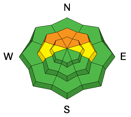
LIKELIHOOD
 LIKELY
UNLIKELY
SIZE
 LARGE
SMALL
TREND
 INCREASING DANGER
SAME
DECREASING DANGER
|
|
description
Whether it's due to additional loading or more triggers, the results speak for themselves. Three (perhaps more unreported?) avalanches into old snow 2-3' deep. It's also likely that we could have received many observations reporting non-events. The structure is not to be trusted (Scorpion and Frog parable, anyone?) and based upon activity yesterday I feel that the danger must be elevated to reflect the true potential danger. The may still be triggered remotely from below. Obvious clues and snow test results may not be present or clearly damning, but again, the structure and avalanches speak for themselves. |
| type | aspect/elevation | characteristics |
|---|

|
|
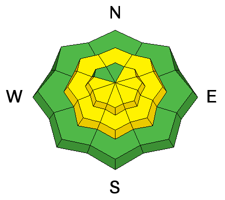
LIKELIHOOD
 LIKELY
UNLIKELY
SIZE
 LARGE
SMALL
TREND
INCREASING DANGER
SAME
DECREASING DANGER
|
|
description
It only takes just a bit of wind to move and slab the very low density snow. Super soft wind drifts may be found in a variety of lee encatchment zones and may be triggered at a distance. The north winds should erode many upper north facing starting zones and drift onto the steep west to south to east facing paths. Terrain channelling at the mid-elevations may allow soft wind drifts to develop on many aspects. |
| type | aspect/elevation | characteristics |
|---|

|
|
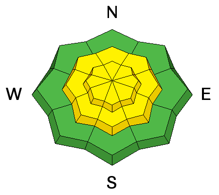
LIKELIHOOD
LIKELY
UNLIKELY
SIZE
LARGE
SMALL
TREND
INCREASING DANGER
SAME
DECREASING DANGER
|
|
description
Watch for the cold smoke to move with human provocation on the steepest slopes of all aspects at the mid and upper elevations. I expect the sluffs to move fast and far on the slick underlying sun and wind crusts, entraining all the storm snow in the path below. The good news is that these types of avalanches readily show their cards and hold little mystery: they respond to ski cuts and cornice drops and break at your feet or machine rather than above you. These avalanches, however, can move at light-speed, easily trip up a slow or unsuspecting skier or rider and pile up deeply in a terrain trap. The key is to move diagonally across the slope or from area of safety to area of safety to avoid being engulfed in your own sluff. Google "sluff-management". |
 |
weather We'll see the last few snowflakes winding down and skies should start to break through the afternoon. 20-25mph northwesterly winds are expected to lose steam over the course of the day. Temps will be in the single digits and low teens. We'll see a few weak disturbances over the next several days with a more potent storm for Thursday/Friday. |
| general announcements CLICK HERE FOR MORE GENERAL INFO AND FAQ Support the UAC through your daily shopping. When you shop at Smith's, or online at REI, Backcountry.com, Patagonia, NRS, Amazon, eBay a portion of your purchase will be donated to the FUAC. See our Donate Page for more details on how you can support the UAC when you shop. Benefit the Utah Avalanche Center when you buy or sell on eBay - set the Utah Avalanche Center as a favorite non-profit in your eBay account here and click on eBay gives when you buy or sell. You can choose to have your seller fees donated to the UAC, which doesn't cost you a penny. This information does not apply to developed ski areas or highways where avalanche control is normally done. This advisory is from the U.S.D.A. Forest Service, which is solely responsible for its content. This advisory describes general avalanche conditions and local variations always occur. |