25th Annual Black Diamond Fall Fundraising Party
Thursday, September 13; 6:00-10:00 PM; Black Diamond Parking Lot
25th Annual Black Diamond Fall Fundraising Party
Thursday, September 13; 6:00-10:00 PM; Black Diamond Parking Lot
| Advisory: Salt Lake Area Mountains | Issued by Mark Staples for Wednesday - January 17, 2018 - 6:20am |
|---|

|
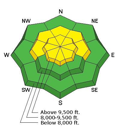
bottom line Yesterday's avalanche on Davenport Hill that caught and carried a skier confirms that avalanches remain possible and the avalanche danger is MODERATE on all upper elevation slopes and mid elevation slopes facing the northern half of the compass from West to East. If you're headed into the backcountry - or exiting though the gates at the ski area - you must have the proper gear, training, and skilled partners.
|
 |
special announcement TONIGHT at 7 p.m. - Join the UAC at Brewvies in your favorite 80's ski gear for a showing of Aspen Extreme. More info HERE. TONIGHT at 6-8 p.m. - Avalanche Awareness for Women at REI in Salt Lake City. It's free but you need to register online. For more info and to register, go HERE. January 18 and 20 - Women's Backcountry 101 Introdution to Avalanches in SLC and at Brighton Ski Resort. Lectures Thursday nigth (1/18) followed by a field day on Saturday (1/20). For more info and to sign up, go HERE. |
 |
current conditions Despite a few passing clouds overnight, no snow fell. Temperatures this morning are in the mid 20's F at most elevations. Light westerly winds are blowing 5-10 mph with gusts of 15 mph. Southerly facing slopes have dampened each day and refrozen on the surface each night. Dry powder still exists on many other slopes. Higher elevation slopes have been wind affected. |
 |
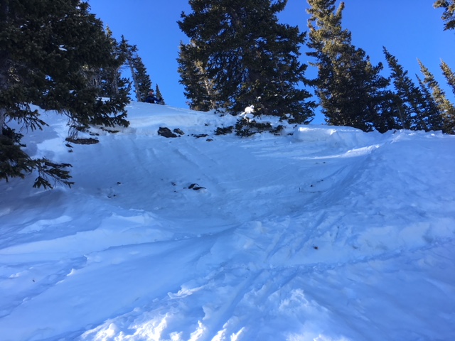
recent activity Yesterday a skier was caught, carried and partially buried in an avalanche on Davenport Hill (at the head of Silver Fork). He was the second skier on the slope and was uninjured. This slide broke on weak, faceted snow buried 2.5 feet deep on a West facing slope at 9800 ft. It was 125 feet wide and ran 300 feet vertical. Another slide was spotted along the upper ridgeline between Mill Creek and Big Cottonwood Canyons just east of Little Water Peak. This slide may have occurred on Monday. Otherwise, the most recent backcountry avalanche activity happened 4 days ago on Saturday. On Sunday at least 9 avalanches were triggered by ski patrols. Full list of backcountry avalanches HERE. Sincere thanks to the party for reporting this avalanche on Davenport Hill. It's crucial and potentially life saving information to share.
|
| type | aspect/elevation | characteristics |
|---|

|
|
LIKELIHOOD
 LIKELY
UNLIKELY
SIZE
 LARGE
SMALL
TREND
 INCREASING DANGER
SAME
DECREASING DANGER
|
|
description
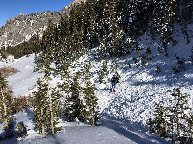
Weak, faceted snow buried 2-3 feet deep was stressed by snowfall last Wednesday and many persistent slab avalanches occurred. The odds of triggering one of these slides has gone down, but yesterday's avalanche on Davenport Hill tells us that the potential remains. Yesterday my partners and I were in Cardiff Fork. Drew and his partner were in nearby Days Fork. We agreed that buried faceted layers have become less sensitive. Ski tracks in steep terrain confirm this decreased sensitivity but don't confirm stability. The trouble now is that the sensitivity of slopes varies widely. Unfortunately we don't have the ability to tell the difference between these slopes with similar snowpack layering. South facing slopes at mid and low elevations that have been roasted by the sun mostly lack buried faceted layers and are generally safe. Unfortuantely these slopes don't have very good riding conditions. Most slopes with good powder and good coverage have the layering that can produce avalanches. Even if you're riding low angle terrain, watch for small steeper slopes that can produce slides like this one that Drew found yesterday.
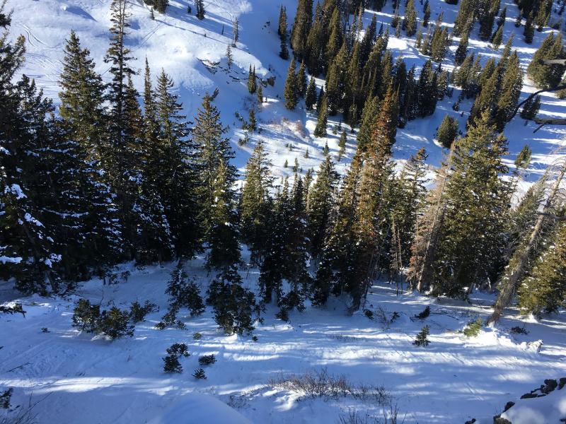
Be especially watchful of the consequecnes of being caught in a slide. If riding in avalanche terrain, choose slopes with a runout free of trees or rocks. My partners and I were horrified yesterday looking at two slides from Saturday in Cardiff Fork that ran through dense trees. Mark White said it best, the slab is soft but those trees are hard. The slide below ran though the trees into the clearing underneath.
|
 |
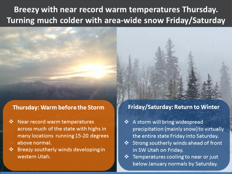
weather High pressure will bring more clear sunny skies today and warm temperatures. Temperatures should warm into the mid to upper 30's and into the 40's F at lower elevations. Winds will remain light. Fortunately, winter weather is coming on Friday, and the good news is that weather models have been consistent with this storm which means we have a high confidence in the weather forecast for Friday and Saturday. About a foot of snow is expected with this storm.
|
| general announcements CLICK HERE FOR MORE GENERAL INFO AND FAQ Support the UAC through your daily shopping. When you shop at Smith's, or online at REI, Backcountry.com, Patagonia, NRS, Amazon, eBay a portion of your purchase will be donated to the FUAC. See our Donate Page for more details on how you can support the UAC when you shop. Benefit the Utah Avalanche Center when you buy or sell on eBay - set the Utah Avalanche Center as a favorite non-profit in your eBay account here and click on eBay gives when you buy or sell. You can choose to have your seller fees donated to the UAC, which doesn't cost you a penny. This information does not apply to developed ski areas or highways where avalanche control is normally done. This advisory is from the U.S.D.A. Forest Service, which is solely responsible for its content. This advisory describes general avalanche conditions and local variations always occur. |