25th Annual Black Diamond Fall Fundraising Party
Thursday, September 13; 6:00-10:00 PM; Black Diamond Parking Lot
25th Annual Black Diamond Fall Fundraising Party
Thursday, September 13; 6:00-10:00 PM; Black Diamond Parking Lot
| Advisory: Salt Lake Area Mountains | Issued by Trent Meisenheimer for Friday - January 12, 2018 - 3:55am |
|---|

|
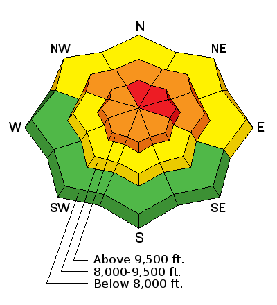
bottom line Strong wind with plenty of snow available to transport has once again risen the Avalanche Danger to HIGH on steep, upper elevation slopes facing north through east. Large, wide, long running avalanches can be triggered on slope or remotely from below or from adjacent slopes. Avoid travel on and below all wind-drifted slopes. Travel in avalanche terrain is not recommended. Be very aware of other people near by in the backcountry - you would never would want to accidentally trigger a slide onto a party below - by remotely triggering a slide or kicking a cornice. Those with skills to identify and avoid avalanche terrain will find great riding and turning on low angle slopes less steep than about 30 degrees, which are not below steeper terrain.
|
 |
special announcement Episode 2 of the UAC podcast has been released. Check it out on ITunes, Stitcher, the UAC blog, or wherever you get your podcasts. |
 |
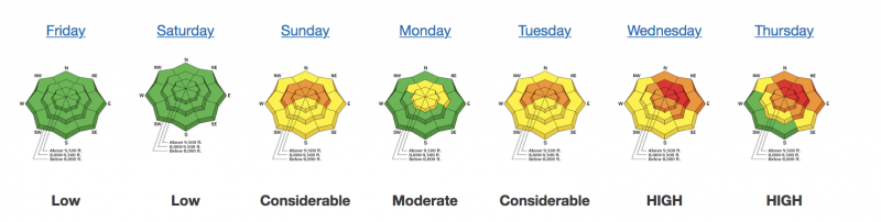
current conditions Overnight a quick hitting small storm rolled through the mountains, leaving behind 1 to 3 inches of snow in places. Unfortunately, this storm also came with a bump in the northwest winds and current speeds at upper elevations are in the 25-35 mph range gusting into the 50's. Temperatures continue to remain on the warm side with ridge line thermometers reporting 25°-30° F. Lower trailheads temps are in the low to mid 30's °F. The riding and turning conditions out of the wind zone will remain excellent. The sun did poke through the clouds yesterday and there could be a slight zipper crust on the more southerly facing aspects. The snow below 8000' is shallow, rain soaked, heavy, and crusted in many areas. Greg Gagne and Drew Hardesty put together an amazing "Week In Review" found HERE. The picture below shows the past seven days of the avalanche danger. Great work you two!
|
 |
recent activity Remotely triggered avalanches continue to be reported from the backcountry - most of these are 1-2' feet deep and several hundred feet wide failing on faceted weak sugary snow. Explosive work showed impressive results with avalanches breaking down close to the ground 3-4' feet deep and up to 400' feet wide. Cracking and collapsing was also reported by many travelers and our snowpit test results continue to show propagation. List of all observations found HERE. A special thanks to everyone who submits observations you are all rock stars! List of all avalanches found HERE. Future tip for your cerebral hardrive: Most of these avalanches are not clearing out the deeper weak layers (depth hoar, large grained faceted snow) and once we receive another load we will see avalanches again on many of these slopes that have already avalanched. Drew Hardesty, Zinnia Wilson, Paul Diegel, and Bo Torry have an excellent video showing their field day from yesterday below. |
| type | aspect/elevation | characteristics |
|---|

|
|
LIKELIHOOD
 LIKELY
UNLIKELY
SIZE
 LARGE
SMALL
TREND
 INCREASING DANGER
SAME
DECREASING DANGER
|
|
description
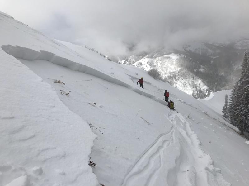
IT'S JUST PLAIN DANGEROUS OUT THERE - slopes that have not avalanched are hanging in balance, just waiting for a trigger. Today, the wind might be that trigger. Many of yesterday’s avalanches broke well off ridgelines, meaning you can get out on to a slope, and have the slide break above you. Any slide you trigger on a steep slope today will be large enough to bury and kill you. This is due to weak sugary snow that is buried in the snowpack with stronger more cohesive snow on top. If you're in a hurry you can stop reading here and move onto the wind slab definition. If your drink is still warm continue on for a brief discussion lower down. Photo: Bo Torry from the Utah Avalanche Center. This was a remotely triggered slide from the ridge line, that was 16" inches deep and 200' feet wide.
In the book " The Art of Science of Prediction" by Philip E. Tetlock & Dan Gardner, they explain the difference between blinking and thinking. The concept is easy, we have two parts to our brains and it's a dichotomy between intuition and analysis - blink vs think. The choice isn't either/or, it is how to blend them in evolving situations. Blinking is the act of using human emotion to make decisions - you quickly decide a slope is safe based on our desire to ride epic powder, you justify things in your mind as stable because your desire is stronger. Analysis, is using all the tools in the tool box and to think, instead of blink: A good start would be to look at the bulls eye clues that tell you if a slope is unstable. 1. Recent Avalanches. 2. Cracking and Collapsing. 3. Significant snow fall within the last 48 hrs. 4. Wind. 5. Recent rapid thaw. I think you can do the quick math on the list above. The book then tells a quick story about a fire chief called to a routine kitchen fire. "The commander order his men to hose down the fire while standing in the living room. The fire subsided at first but roared back. The commander was baffled. He also noticed the living room was surprisingly hot given the size of the kitchen fire. And why was it so quiet? A fire capable of generating that much heat should make more noise. A vague feeling of unease came over the commander and he ordered everyone out of the house. Just as the firefighters reached the street, the floor in the living room collapsed - because the real source of the fire was in the basement, not the kitchen." There is nothing mystical about an accurate intuition like the fire commander's. It's pattern recognition - like cueing in on the 5 clues to avalanches. If you're seeing avalanches, hearing about avalanches - guess what? YOU CAN TRIGGER AVALANCHES. Ian McCammon did roughly the same thing when he created the system called ALPTRUTH. He wondered why skilled people were dying in the backcountry. He looked at hundreds of avalanche accidents and came up with a list of seven factors that were present in many, if not all of the backcountry accidents he studied. The list is below: 1. Avalanches in the past 48 hrs? 2. Loading by snow, wind or rain in the past 48 hrs? 3. Path - are you in an avalanche path? 4. Terrain Trap - Gullies, trees, cliffs or other features that increase the severity of being caught? 5. Rating - Considerable or higher avalanche hazard on the current advisory? 6. Unstable Snow - Collapsing, cracking, hollow sounding snow or other clear evidence of instability? 7. Thaw - Recent warming of the snow surface due to sun, rain or warm air? The process is simple: for every factor present you give it a score of 1. Ian McCammon found that in almost all of the avalanche accidents he looked at had 3 or more points assigned. To be very clear, if you simply didn't go anytime that 3 or more points are present, you would avoid almost all avalanche accidents. How many points are already checked for today? I count 4. |
| type | aspect/elevation | characteristics |
|---|

|
|
LIKELIHOOD
 LIKELY
UNLIKELY
SIZE
 LARGE
SMALL
TREND
INCREASING DANGER
SAME
DECREASING DANGER
|
|
description
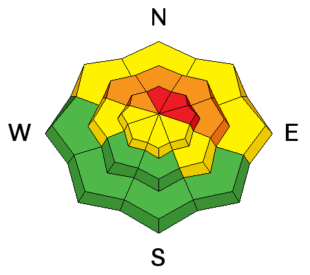
Northwest winds ramped up overnight and into this morning with ridgetop speeds of 25- 35 mph gusting into the 50's. This is creating fresh drifts of wind blown snow. This will provide the extra weight needed to once again tip the balance. Avoid any fresh drift of wind blown snow. If you trigger a wind slab on the northerly facing terrain you will then likely trigger a much deeper and more dangerous avalanche that has potential to step down into deeper weak layers. Travel adivse - continue to avoid being on, underneath, or adjacent to any terrain steeper than 30°. |
 |
weather We are under a moist northwest flow for much of the day today with a trace to two inches of snow possible. The big headline will be the northerly winds are supposed to remain strong through the morning hours with forecasted speeds in the 20-30 mph range gusting into the 50's at ridgetop. Temperatures will remain balmy and by the afternoon we should warm up into the low 30's at 9000' feet. The storm will exit the area this evening and high pressure returns for the weekend with another storm slated for Tuesday into Wednesday. |
| general announcements CLICK HERE FOR MORE GENERAL INFO AND FAQ Support the UAC through your daily shopping. When you shop at Smith's, or online at REI, Backcountry.com, Patagonia, NRS, Amazon, eBay a portion of your purchase will be donated to the FUAC. See our Donate Page for more details on how you can support the UAC when you shop. Benefit the Utah Avalanche Center when you buy or sell on eBay - set the Utah Avalanche Center as a favorite non-profit in your eBay account here and click on eBay gives when you buy or sell. You can choose to have your seller fees donated to the UAC, which doesn't cost you a penny. This information does not apply to developed ski areas or highways where avalanche control is normally done. This advisory is from the U.S.D.A. Forest Service, which is solely responsible for its content. This advisory describes general avalanche conditions and local variations always occur. |