25th Annual Black Diamond Fall Fundraising Party
Thursday, September 13; 6:00-10:00 PM; Black Diamond Parking Lot
25th Annual Black Diamond Fall Fundraising Party
Thursday, September 13; 6:00-10:00 PM; Black Diamond Parking Lot
| Advisory: Salt Lake Area Mountains | Issued by Greg Gagne for Sunday - November 26, 2017 - 3:12pm |
|---|

|
bottom line The avalanche hazard is LOW. With a couple of possible small storms early this coming week, the hazard may elevate due to fresh storm snow as well as possible wind drifting. On upper elevation northwest through northeast aspects, weak faceted snow near the ground creates a persistent slab hazard. Remember - a low avalanche hazard doesn't mean no avalanches. We will continue with intermittent advisories until we begin to receive more snow.
|
 |
special announcement Support the UAC when you shop Whole Foods Market at Trolley Square, Sugarhouse, and Cottonwood Heights. Between now and Jan 11th, Whole Foods will donate a dime per bag to Utah Avalanche Center when you shop there and donate your bag credit during check out. See below or the YouTube link to see a review of what's going on with our snowpack and our current avalanche concerns. Special thanks to Steve Lloyd for this project. Unopened ski area terrain has a backcountry snowpack, as avalanche mitigation work has not been done. Each resort has different uphill travel policies - please abide by signage and closures and check in with the local ski patrol. |
 |
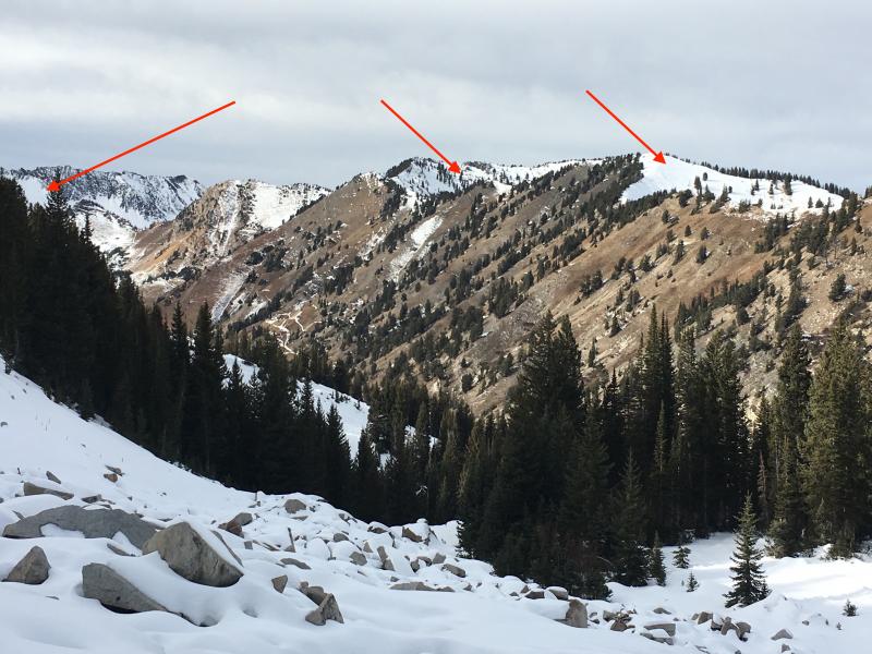
current conditions Conditions as of 3 pm Sunday afternoon feature very mild temperatures with increasingly strong south and southwest winds. Temperatures at 10,500' are in the mid 40's F with gusts over 50 mph from the south. A rain event to 10,000' early last week, along with very warm temperatures over the Thanksgiving holiday, have crusted most snow surfaces. Southerly aspects have largely melted off, with patches of snow clinging to southeast and southwest aspects. Northerly aspects > 9000' hold about 18-24" of snow (red arrows)
|
 |
recent activity There has been no reported avalanche activity since Saturday Nov 18. Recent observations from the central Wasatch: Little Cottonwood Canyon (Alta) (Nov 26) Big Cottonwood Canyon (Brighton) (Nov 25) Little Cottonwood Canyon (Alta) (Nov 23) Little Cottonwood Canyon (Alta) (Nov 23) |
| type | aspect/elevation | characteristics |
|---|

|
|
LIKELIHOOD
 LIKELY
UNLIKELY
SIZE
 LARGE
SMALL
TREND
 INCREASING DANGER
SAME
DECREASING DANGER
|
|
description
The snowpack is currently stable and avalanches are unlikely. However, with a couple of possible weather systems early this week, the avalanche hazard may elevate:
Although any storm slabs or wind drifts will be quite shallow, even a short ride on our thin snowpack will mean a ride over rocks and stumps. |
| type | aspect/elevation | characteristics |
|---|

|
|
LIKELIHOOD
LIKELY
UNLIKELY
SIZE
 LARGE
SMALL
TREND
INCREASING DANGER
SAME
DECREASING DANGER
|
|
description
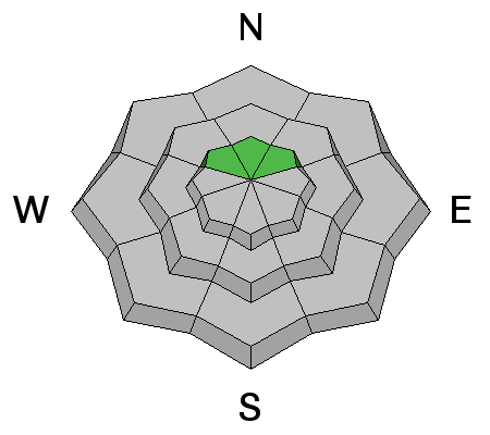
Despite the very warm weather over the past several days, the weak, faceted snow at the bottom of our snowpack on upper elevation northwest through northeast aspects remains. This video from Thursday highlights this very weak snow: Currently, these weaknesses are mostly dormant, and the likelihood of triggering one of these persistent slab avalanches is quite low. But persistent weaknesses will show their hand once again with new loading such as storm snow and/or wind deposited snow. |
 |
weather Cloudy, windy, and mild through early Monday afternoon when we can expect a quick-hitting storm that may bring 3-6" on a northwest flow. Clearing Monday night followed by cool high pressure on Tuesday. Another quick-hitter is possible for Wednesday, with a few more inches of additional snowfall. Models are hinting at something more promising for late this coming weekend. |
general announcements
|