Observation: Little Cottonwood Canyon

Observation Date
11/26/2017
Observer Name
Greg Gagne
Region
Salt Lake » Little Cottonwood Canyon
Location Name or Route
Alta
Weather
Sky
Overcast
Wind Direction
South
Wind Speed
Moderate
Weather Comments
Increasingly strong gusts out of the south. Very mild temps Alta base (8600') in the mid 50's F, top of Collins (10,500') in the mid 40's F.
Snow Characteristics
Snow Surface Conditions
Melt-Freeze Crust
Rain-Rime Crust
Damp
Snow Characteristics Comments

About 45-60 cms (18-24") in upper elevations. All aspects I noted today (as high as 10,500') were crusted at the surface. South aspects have melted off leaving mostly bare ground. Patches of snow remain on SE and SW aspects.

Red Flags
Red Flags
Poor Snowpack Structure
Red Flags Comments
Despite the warm weather, the weaknesses at the base of the snowpack on NW through NE aspects above about 9500' remain.
Avalanche Problem #1
Problem
Persistent Weak Layer
Trend
Same
Problem #1 Comments

Was able to get an ECTP12 SC on a northwest aspect at 9900', failing in a layer of faceted snow down near the ground. Despite the full propagation, not much energy in the slab (i.e. it didn't "pop" out of the pit) and the general feeling is the weaknesses at the base of our snowpack are currently dormant, but likely to become active again with a sufficient new load.

Thanks to the recent stretch of very warm weather, the top ~10-15 cms (4-6") has crusted and is damp below crusts. This has stiffened up the slab, creating a relatively strong 4F slab on top of weaknesses at the base of the snowpack. Am concerned this stronger slab on top will support greater loads. However, at some point we will likely overload these weaknesses creating possibly larger avalanches.

Comments

Pit from just below 10,000' on northwest aspect. Dirty graupel layer has compressed somewhat since last weekend.

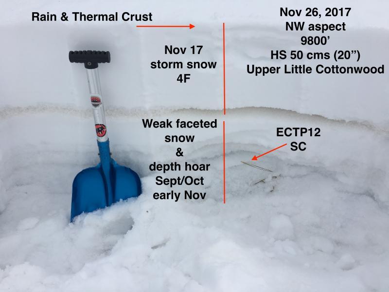
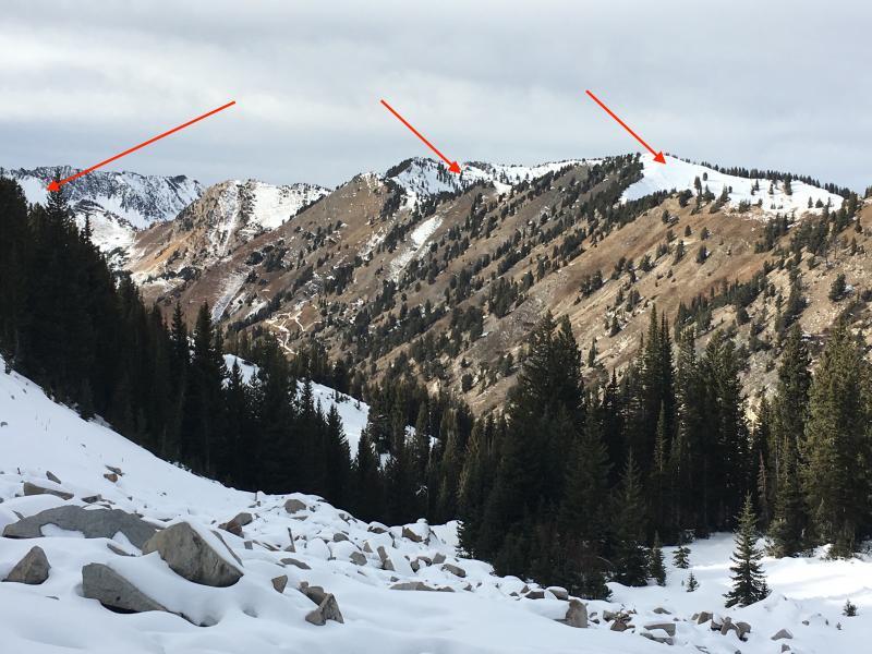
Photo of southerly aspects in upper LCC - arrows pointing to Silver, Days, Cardiff forks where weak snow on upper elevation NW through NE aspects remains.

Today's Observed Danger Rating
Low
Tomorrows Estimated Danger Rating
Low