25th Annual Black Diamond Fall Fundraising Party
Thursday, September 13; 6:00-10:00 PM; Black Diamond Parking Lot
25th Annual Black Diamond Fall Fundraising Party
Thursday, September 13; 6:00-10:00 PM; Black Diamond Parking Lot
| Advisory: Salt Lake Area Mountains | Issued by Greg Gagne for Saturday - April 29, 2017 - 6:06am |
|---|

|
bottom line This advisory is for Saturday and Sunday April 29, 30. The primary avalanche concerns for this weekend are (1) Fresh wind drifts forming from the northerly and easterly winds. These drifts may be found on a variety of aspects at the mid and upper elevations. (2) Wet avalanches as this week's storm snow warms from direct sun or greenhousing. Please remember to practice safe protocol by skiing steep slopes one a time and get out of the way at the bottom of a runout zone. If you perform a ski cut a drop a cornice onto a slope, make sure no one is below you. Most ski resorts are closed for the season and they no longer perform avalanche mitigation, so treat them just like backcountry terrain. Additionally, be sure to follow any restrictions the closed resorts may have for uphill travel.
|
 |
special announcement UPDATE: Sunday, April 30, Alta Ski Area is OPEN to uphill traffic We have stopped issuing regular avalanche advisories for the 2016/2017 season. For the rest of the month we will issue Friday updates for the central Wasatch Mountains and updates any time there is measurable snowfall; however, we have discontinued issuing avalanche danger ratings altogether. |
 |
current conditions At 6 am on Saturday mountain temperatures are in the low to mid teens and winds are out of the north/northeast, gusting into the 20's mph at low and mid elevations, and the 30's mph at 11000'. Overnight snow totals are 3" in both Big and Little Cottonwood Canyons, adding to the 8" that fell during the day on Friday. Approximate storm totals this past week are 18-48" with over 4.5" of water, with Little Cottonwood Canyon on the higher end of snow and water totals. Week in Review Perhaps Ullr is thanking us for our perseverance the past several seasons as the last week of April delivered Winter 2.0: Friday April 21 featured 8" of snow in the Cottonwoods with minor sluffing and small, wet-loose activity reported. Saturday brought an extended period of east winds and cool temperatures with several skier-triggered slides from fresh wind drifts in the upper elevations. Sunday included wet loose activity as the sun warmed the snow surface. Snowfall began on Monday and continued well into Tuesday. Storm totals at Alta totaled 26" with 2.6" of water. Snowfall rates of 3-4" per hour were observed in upper Little Cottonwood Canyon, generating an early-morning natural cycle with several natural as well as skier-triggered avalanches running at the new snow/old snow interface. As is often the case in the Spring, by Wednesday conditions rapidly settled out with only minor wet loose activity reported. Snowfall began overnight Wednesday into Thursday, with 10" of snow in LCC, and about half that amount in BCC and the Park City ridgeline. This storm featured strong northwest winds that created sensitive wind slabs in the mid and upper elevations, with several human-triggered avalanches reported. The largest reported slide was on a SE aspect in Cardiff Bowl, and over 1000' wide. Friday remained cold with up to an additional 8" of very low-density snow and reduced winds. Snow depths are up to 160" in upper Little Cottonwood and 136" in upper Big Cottonwood (elevations 9600') . The Ogden mountains still boast 90"-105" (8000' elevation sites) and the Provo mountains have 100" at 8800' elevation. The Alta Guard broke 500" during Tuesday's storm for the 18th time since 1944 and the first time since 2010/2011. Alta Guard monthly snowfall can be found here. For more information: |
 |
recent activity Observers on Friday noted sluffing in the top few inches of the very low-density storm snow as well as some minor wind drifts just along the ridgelines. Although most found instabilities with Thursday's wind slabs to have settled out, there were two reports of unintentional, human-triggered wind slab avalanches on Friday: - East aspect at 9400' on Murdock Peak - Southeast aspect at 10000' on Little Superior Both slides were reported to be 12" deep and breaking out 60' wide. Full list of reported avalanches HERE Other observations HERE. Although we will be shutting down regular operations, we will continue to post recent avalanche activity and observations, so please do continue to send them to us. You can check the latest observations here. We also follow avalanche-related activity on Instagram - be sure to tag your photos with #utavy . |
| type | aspect/elevation | characteristics |
|---|

|

|
LIKELIHOOD
 LIKELY
UNLIKELY
SIZE
 LARGE
SMALL
TREND
 INCREASING DANGER
SAME
DECREASING DANGER
|
|
description
Friday's low-density snow will be easy pickings for Saturday's easterly winds where you may find fresh wind drifts at the mid and upper elevations. Watch for signs of instability such as cracking and collapsing of any recently drifted snow. A common theme of avalanche activity this past week was a general surprise at how widely avalanches were propagating. |
| type | aspect/elevation | characteristics |
|---|

|

|
LIKELIHOOD
LIKELY
UNLIKELY
SIZE
LARGE
SMALL
TREND
INCREASING DANGER
SAME
DECREASING DANGER
|
|
description
Although temperatures are forecasted to remain cool through the weekend, Friday's low-density snow will instantly become sensitive to any warming from either direct sun or greenhousing. Watch for signs of warming including rollerballs and wet sluffs. Be sure to get off of - and out from underneath - any steep slopes that are showing obvious signs of warming. The wind slabs that formed during Thursday's strong west/northwest winds (and are now buried underneath Friday's storm snow), as well as fresh wind slabs, may also be reactive and create a wet slab situation as they warm. For more information on these and other avalanche problems in general, check in with the Avalanche Problem Toolbox. |
| type | aspect/elevation | characteristics |
|---|

|
|
LIKELIHOOD
LIKELY
UNLIKELY
SIZE
LARGE
SMALL
TREND
INCREASING DANGER
SAME
DECREASING DANGER
|
|
description
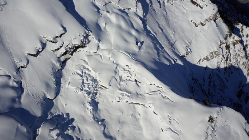
Cornices - The monster cornices that have graced our ridgelines this winter have sagged, and may become reactive with any warming. Be sure to give them a wide berth when traveling along corniced ridgelines, and avoid travel underneath them. Glide Avalanches - Although lower elevations and south aspects are beginning to melt out, there is still a deep, 10' snowpack in the upper elevations. The following aerial photo from April 5 shows glide cracks in Stairs Gulch. With a deep snowpack in the alpine regions, Spring mountaineering conditions are prime right now in the Wasatch. However, certain drainages in Big Cottonwood Canyon - including Stairs Gulch, Mill B South, and Broads Fork - are also known paths for glide avalanches, and this terrain should be avoided. (We received an excellent, personalized observation discussing glide avalanches, and you can also visit Bruce Tremper's blog on glide avalanches as well.)
|
 |
weather Partly cloudy through the weekend with mountain temperatures gradually rising into the 20's and 30's F, with 8000' temperatures rising into the 40's F. Saturday's northeasterly winds will veer northerly later Saturday night, and from the northwest Sunday. Winds will gust into the 20's mph at the mid elevations, and 40's at upper elevations. |
general announcements
|