25th Annual Black Diamond Fall Fundraising Party
Thursday, September 13; 6:00-10:00 PM; Black Diamond Parking Lot
25th Annual Black Diamond Fall Fundraising Party
Thursday, September 13; 6:00-10:00 PM; Black Diamond Parking Lot
| Advisory: Salt Lake Area Mountains | Issued by Drew Hardesty for Thursday - April 27, 2017 - 6:15am |
|---|

|
bottom line EXTRA CAUTION ADVISED: Human triggered wind and storm slabs are probable in steep wind drifted terrain this morning. They'll be most pronounced on steep north to east to south facing terrain of the mid and upper elevations. Note that conditions can turn on a dime in the springtime: with any periods of direct sun, the snow is likely to become damp and unstable, leading to the potential of natural wet avalanches. Most ski resorts are closed for the season and they no longer perform avalanche mitigation, so treat them just like backcountry terrain. Additionally, be sure to follow any restrictions the closed resorts may have for uphill travel. Alta ski area is currently closed to uphill traffic.
|
 |
special announcement Alta is closed to uphill traffic today. We have stopped issuing regular avalanche advisories for the 2016/2017 season. For the rest of the month we will issue Friday updates for the central Wasatch Mountains and updates any time there is measurable snowfall; however, we have discontinued issuing avalanche danger ratings altogether. |
 |
current conditions Overnight snow totals are up to 10" (.97" snow water equivalent) in upper Little Cottonwood, with about half that amount in Big Cottonwood and the Park City ridgeline. The Ogden area mountains picked up 5" and the Provo area mountains 2-4". The snowfall intensity was particularly high between 2 and 4am, leading to a natural avalanche cycle during those hours. Snowfall appears to be a bit more showery now with "face-stinging graupel" currently being reported in the Cottonwoods. Winds ramped up out of the west northwest around 2am and are blowing 25-30mph with gusts to near 50. Even the Reynolds Peak weather station in mid-BCC has hourly averages of 20-25mph with gusts to 35. 11,000' winds are 45mph with gusts to 65. Temps are in the low 20s. Snow depths are up to 150" in upper Little Cottonwood and 136" in upper Big Cottonwood (elevations 9600') . The Ogden mountains still boast 90"-105" (8000' elevation sites) and the Provo mountains have 100" at 8800' elevation. The Alta Guard broke 500" during Tuesday's storm for the 18th time since 1944 and the first time since 2010/2011. Alta Guard monthly snowfall can be found here. For more information: |
 |
recent activity Yesterday: Tuesday's widespread instability mostly stabilized yesterday with only one size 2 natural reported in the radical terrain of Tanners Gulch in mid-LCC. Narrow windows of "sun-breaks" (as the Pacific northwesterners call them) aided and abetted the warming and greenhousing to allow for some minor rollerballing and push-a-lanches as the Tuesday storm snow dampened to become unstable in localized terrain. This morning: As mentioned above, the high precipitation intensity and strong west to northwest winds led to a natural avalanche cycle noted in the steep south facing mid-canyon paths of Little Cottonwood, with another noted this morning on Hellgate. All estimated to be size 2 (big enough to bury a person). Refer place names to Wasatch Backcountry Skiing map. Full list of reported avalanches HERE Other observations HERE. Although we will be shutting down regular operations, we will continue to post recent avalanche activity and observations, so please do continue to send them to us. You can check the latest observations here. We also follow avalanche-related activity on Instagram - be sure to tag your photos with #utavy . |
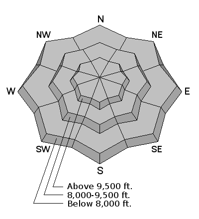
| type | aspect/elevation | characteristics |
|---|

|
|
LIKELIHOOD
 LIKELY
UNLIKELY
SIZE
 LARGE
SMALL
TREND
 INCREASING DANGER
SAME
DECREASING DANGER
|
|
description
The moderate to strong west to northwest winds will easily promote wind slab formation both to the lee of the high ridgelines but also cross-loaded beyond sub-ridges and other terrain features as they race up the westerly drainages of the central Wasatch mountains. Even the base of Alta has gusts into the 30s. Both wind slabs and storm snow slabs will be particularly sensitive to human provocation this morning on all steep terrain of the mid and upper elevations, most notably on steep north to east to south facing terrain. Overall stability should slowly improve as the day wears on. Test slopes and snow tests should provide meaningful information to go along with the classic signs of instability in the form of cracking and collapsing of any recently drifted snow. Note that the drifts may be up to 18-20"+ in heavily loaded terrain while the storm slabs will be about half that. In a nutshell: sensitive, widespread and up to 2' deep. For more infomation on these and other avalanche problems in general, check in with the Avalanche Problem Toolbox. |
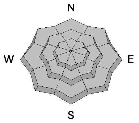
| type | aspect/elevation | characteristics |
|---|

|

|
LIKELIHOOD
LIKELY
UNLIKELY
SIZE
LARGE
SMALL
TREND
INCREASING DANGER
SAME
DECREASING DANGER
|
|
description
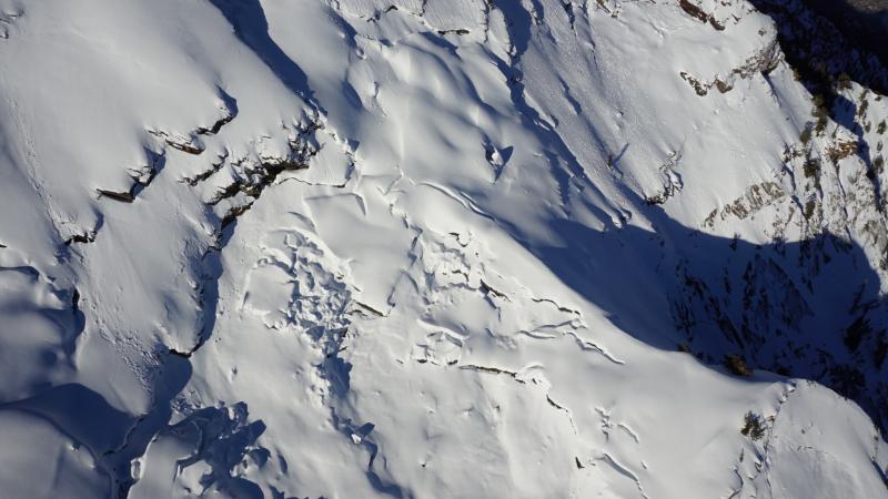
Wet Snow Avalanches - These are always a possibility in the spring. With so much new snow, these avalanches will occur as soon as the sun appears. Even an hour of strong sunshine could start a cycle of wet snow avalanches. Glide Avalanches - Although lower elevations and south aspects are beginning to melt out, there is still a deep, 10' snowpack in the upper elevations. The following aerial photo from April 5 shows glide cracks in Stairs Gulch. With a deep snowpack in the alpine regions, Spring mountaineering conditions are prime right now in the Wasatch. However, certain drainages in Big Cottonwood Canyon - including Stairs Gulch, Mill B South, and Broads Fork - are also known paths for glide avalanches, and this terrain should be avoided. (We received an excellent, personalized observation discussing glide avalanches, and you can also visit Bruce Tremper's blog on glide avalanches as well.)
|
 |
weather We'll see intermittent showers today with some possibility of additional "sun breaks". Temps will remain generally cool along the ridgelines with a cooling trend continuing through tomorrow. Ridgetop temps will be in the upper teens to low 20s. Winds should be at their highest hourly averages now, but expect the west to northwesterlies to blow 20-25mph throughout the day. We should see a few more inches tonight with additional "wrap-around" moisture with the departing Low pressure system tomorrow into Saturday. It may all add up to another 5-10" by then. |
general announcements
|