25th Annual Black Diamond Fall Fundraising Party
Thursday, September 13; 6:00-10:00 PM; Black Diamond Parking Lot
25th Annual Black Diamond Fall Fundraising Party
Thursday, September 13; 6:00-10:00 PM; Black Diamond Parking Lot
| Advisory: Salt Lake Area Mountains | Issued by Mark Staples for Wednesday - April 26, 2017 - 7:11am |
|---|

|
bottom line Intense snowfall yesterday created a period of dangerous avalanche conditions. With 2 feet of snow falling at a fast rate, many natural and human triggered slides occurred. Avalanches should be harder to trigger today, but safely traveling in avalanche terrain will require a careful evaluation of the snowpack and terrain. More snow coming this afternoon could increase the risk of avalanches. Most ski resorts are closed for the season they no longer perform avalanche mitigation, so treat them just like backcountry terrain. Additionally, be sure to follow any restrictions closed resorts may have for uphill travel. Alta ski area is currently closed to uphill traffic.
|
 |
special announcement Alta is closed to uphill traffic today. We have stopped issuing regular avalanche advisories for the 2016/2017 season. For the rest of the month we will issue Friday updates for the central Wasatch Mountains and updates any time there is measurable snowfall; however, we have discontinued issuing avalanche danger ratings altogether. |
 |
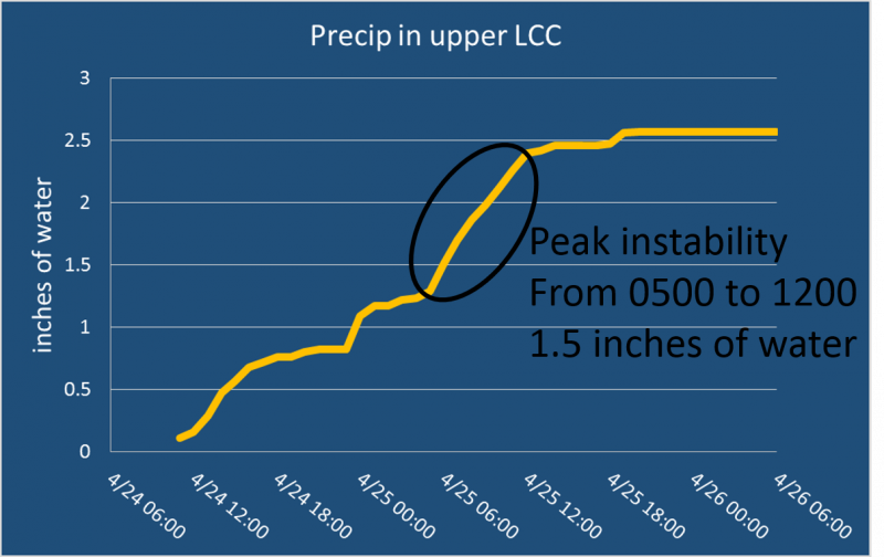
current conditions No new snow fell overnight. Yesterday's storm total in upper Little Cottonwood was 26.5 inches of snow (containing 2.66 inches of water). Snowfall was intense yesterday morning when the peak period of instability occurred. See graph below of water amounts in upper Little Cottonwood Canyon. This morning, temperatures are in the 20's F. Upper 20's around 8500 feet and low 20's near 10k feet. Winds are a little gusty at low and mid elevations; otherwise at ridgetops they are blowing westerly 10-15 mph and gusting 20 mph. Winds blew a few mph stronger just after midnight. Temperatures at 8500 feet yesterday reached 40 degrees F and some solar radiation warmed the clouds which warmed the snow that became wet at low and mid elevations.
For more information: |
 |
recent activity There was a lot of avalanche activity yesterday, both natural and human triggered. These slides were breaking up to 2 feet deep, and most appeared to break at the new snow/old snow interface. The most notable aspect of these slides was that many propagated several hundred feet. Also they did not appear to occur as a result of wind loading. Full list of reported avalanches HERE Other observations HERE. Below is a video showing an avalanche in Grizzly Gulch that broke over 250 ft wide. Although we will be shutting down regular operations, we will continue to post recent avalanche activity and observations, so please do continue to send them to us. You can check the latest observations here. We also follow avalanche-related activity on Instagram - be sure to tag your photos with #utavy . |
| type | aspect/elevation | characteristics |
|---|

|

|
LIKELIHOOD
 LIKELY
UNLIKELY
SIZE
 LARGE
SMALL
TREND
 INCREASING DANGER
SAME
DECREASING DANGER
|
|
description
Storm slab avalanches should have healed considerable today, I'm uncertain exactly how much the new snow has bonded to the old snow. You'll have to assess the bond between the new and old snow with stability tests like the ECT and by testing small slopes. Conditions change quickly this time of year and can be completely different between morning, mid-da,y and afternoon; therefore, assess every slope throughout the day. Photo below of a very wide storm slab avalanche in Grizzly Gulch. This slide was on a slope not affected by the wind yet propagated over a surprisingly wide area.
|
| type | aspect/elevation | characteristics |
|---|

|

|
LIKELIHOOD
LIKELY
UNLIKELY
SIZE
LARGE
SMALL
TREND
INCREASING DANGER
SAME
DECREASING DANGER
|
|
description
With so much new snow available for transport, there's a good chance you can find fresh wind slabs that are unstable this morning, mainly at the highest elevations where the snow remains dry and winds are the strongest. During the last 48 hours winds have blown from the W and NW. |
| type | aspect/elevation | characteristics |
|---|

|
|
LIKELIHOOD
LIKELY
UNLIKELY
SIZE
LARGE
SMALL
TREND
INCREASING DANGER
SAME
DECREASING DANGER
|
|
description
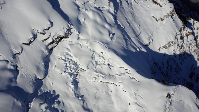
Wet Snow Avalanches - These are always a possibility in the spring. With so much new snow, these avalanches will occur as soon as the sun appears. Even an hour of strong sunshine could start a cycle of wet snow avalanches. Additionally, there is no rain in the forecast later today (just snow) but anything is possible, and the slightest amount of rain could also start a cycle of wet snow avalanches. Glide Avalanches - Although lower elevations and south aspects are beginning to melt out, there is still a deep, 10' snowpack in the upper elevations. The following aerial photo from April 5 shows glide cracks in Stairs Gulch. With a deep snowpack in the alpine regions, Spring mountaineering conditions are prime right now in the Wasatch. However, certain drainages in Big Cottonwood Canyon - including Stairs Gulch, Mill B South, and Broads Fork - are also known paths for glide avalanches, and this terrain should be avoided. (We received an excellent, personalized observation discussing glide avalanches, and you can also visit Bruce Tremper's blog on glide avalanches as well.)
|
 |
weather From the National Weather Service office in Salt Lake City: "Snow is expected to develop later this morning, in advance of a cold front which will cross the area this evening. A cold and unstable northwest flow will follow for Thursday and Friday.." Temperatures today at 8500 feet should rise to almost 40 degrees F. Snowfall should start this afternoon and produce 10-16 inches of additional snow by tomorrow morning. Winds at 10,000 ft ridgelines should blow 5-15 mph from the SW and gust to 25 mph.
|
general announcements
|