25th Annual Black Diamond Fall Fundraising Party
Thursday, September 13; 6:00-10:00 PM; Black Diamond Parking Lot
25th Annual Black Diamond Fall Fundraising Party
Thursday, September 13; 6:00-10:00 PM; Black Diamond Parking Lot
| Advisory: Salt Lake Area Mountains | Issued by Mark Staples for Tuesday - April 25, 2017 - 6:47am |
|---|

|
bottom line Heavy snow started falling at 11 am yesterday and was still falling this morning. That amount of snow by itself can cause avalanches. At upper elevations, strong W and NW winds blew overnight and formed fresh wind slabs that should easily fracture this morning. Most ski resorts are closed for the season they no longer perform avalanche mitigation, so treat them just like backcountry terrain. Additionally, be sure to follow any restrictions closed resorts may have for uphill travel.
|
 |
special announcement We have stopped issuing regular avalanche advisories for the 2016/2017 season. For the rest of the month we will issue Friday updates for the central Wasatch Mountains and updates any time there is measurable snowfall; however, we have discontinued issuing avalanche danger ratings altogether. Watch the video below about things to watch for this spring. This does not mean the end of avalanches. Spring storms and warm temperatures may make avalanche danger rise. If you scroll down, we provide some general avalanche advice to follow for typical spring weather patterns and we provide a series of other links you can use for current conditions and mountain weather. |
 |
current conditions As of 6 a.m. in Little Cottonwood Canyon at 9700 feet, 15 inches of snow fell containing 1.5 inches of water. At 7400 feet in Big Cottonwood, 4 inches of snow had accumulated. The Snowbird webcam image from 6 a.m. showed over 12 inches of snow with more falling. Temperatures were at freezing yesterday during the start of the storm and had dropped to 23 degrees F this morning at 9700 ft. At higher elevations, temperatures started in the upper 20's F and were in the upper teens and low 20's this morning. These temperatures mean that snow started warm and dense and became lighter and drier as the storm progressed overnight. Winds from the W and NW are a concern at the highest elevations. While they calmed a bit this morning, overnight winds were blowing:
For more information: |
 |
recent activity East winds this weekend transported the new snow from last Thursday/Friday and formed some fresh wind slabs. At least three slides were triggered near Alta (which is closed and has backcountry conditions) on slopes above 10,000 ft on Saturday. These averaged about 12 inches deep. My partner and I triggered a wind slab on Friday that broke about a foot deep on a layer within the storm snow. By Sunday, wet loose avalanches occurred as temperatures warmed and strong sunshine made the new snow wet. Although we will be shutting down regular operations, we will continue to post recent avalanche activity and observations, so please do continue to send them to us. You can check the latest observations here. We also follow avalanche-related activity on Instagram - be sure to tag your photos with #utavy . |
| type | aspect/elevation | characteristics |
|---|

|
|
LIKELIHOOD
 LIKELY
UNLIKELY
SIZE
 LARGE
SMALL
TREND
 INCREASING DANGER
SAME
DECREASING DANGER
|
|
description
Storm Slab Avalanches - The red flag this morning is snow falling at the rate of several inches per hour. There are likely several different layers in the new snow (and probably some graupel) that could act as a weak layer for today.
Fortunately, this storm started warm and became cooler which produced "right side up" snow. This is a good sign. However, snowfall has been intense which means it will need more time to stabilize. Additionally, watch for warming temperatures and continued snowfall today which could make the new snow become "upside down" meaning there is heavier snow on top of lighter snow. |
| type | aspect/elevation | characteristics |
|---|

|

|
LIKELIHOOD
LIKELY
UNLIKELY
SIZE
LARGE
SMALL
TREND
INCREASING DANGER
SAME
DECREASING DANGER
|
|
description
With 15 inches of snow, more falling, and strong overnight winds from the W and NW, watch for fresh wind slabs on slopes at upper elevations. Wind slabs could easily be 2 feet deep. I would be surprised not to hear about wind slab avalanches being triggered today at the highest elevations. Wind slabs formed overnight may be hidden by snow falling this morning, so pay attention to how the snow feels under your feet. If it feels slabby, punchy, or stiff, it is likely a sign of a fresh wind slab that could fracture and produce an avalanche. |
| type | aspect/elevation | characteristics |
|---|

|

|
LIKELIHOOD
LIKELY
UNLIKELY
SIZE
LARGE
SMALL
TREND
INCREASING DANGER
SAME
DECREASING DANGER
|
|
description
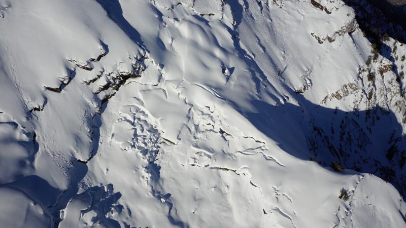
Wet Snow Avalanches - These are always a possibility in the spring. Although no sunshine is forecasted today, watch for any rain falling on new snow which would cause loose, wet avalanches to occur. This should only be an issue at lower elevations. Glide Avalanches - Although lower elevations and south aspects are beginning to melt out, there is still a deep, 10' snowpack in the upper elevations. The following aerial photo from April 5 shows glide cracks in Stairs Gulch. With a deep snowpack in the alpine regions, Spring mountaineering conditions are prime right now in the Wasatch. However, certain drainages in Big Cottonwood Canyon - including Stairs Gulch, Mill B South, and Broads Fork - are also known paths for glide avalanches, and this terrain should be avoided. (We received an excellent, personalized observation discussing glide avalanches, and you can also visit Bruce Tremper's blog on glide avalanches as well.)
|
 |
weather From the National Weather Service office in Salt Lake City: "A low pressure system aloft will maintain periods of snow through today. High pressure will briefly follow tonight into Wednesday morning, before another series of storm systems impacts the region for the latter half of the week." Temperatures today at 8500 feet should rise to near 30 degrees F. Snowfall will continue but taper off this afternoon producing another 3-6 inches . Winds at 11,000 feet should blow 20-30 mph from the NW and gust up to 45 mph. At ridgelines at 10,000 feet, winds should blow 10-20 mph.
|
general announcements
|