25th Annual Black Diamond Fall Fundraising Party
Thursday, September 13; 6:00-10:00 PM; Black Diamond Parking Lot
25th Annual Black Diamond Fall Fundraising Party
Thursday, September 13; 6:00-10:00 PM; Black Diamond Parking Lot
| Advisory: Salt Lake Area Mountains | Issued by Greg Gagne for Friday - April 21, 2017 - 5:18pm |
|---|

|
bottom line Remember after each ski resort closes for the season they no longer perform avalanche mitigation, so treat it just like backcountry terrain. Additionally, be sure to follow any restrictions closed resorts may have for uphill travel.
|
 |
special announcement We have stopped issuing regular avalanche advisories for the 2016/2017 season. For the rest of the month we will issue Friday updates for the central Wasatch Mountains and updates any time there is measurable snowfall; however, we have discontinued issuing avalanche danger ratings altogether. Watch the video below about things to watch for this spring. This does not mean the end of avalanches. Spring storms and warm temperatures may make avalanche danger rise. If you scroll down, we provide some general avalanche advice to follow for typical spring weather patterns and we provide a series of other links you can use for current conditions and mountain weather. |
 |
current conditions A quick-hitting storm overnight Thursday delivered 8-10" of 10% density snow to the Cottonwoods. This right-side up storm came in dense and warm, bonding well to the old snow surface, with lower-density snow at the surface. Friday morning temperatures started out in the mid teens, and stayed relatively cool throughout the day, remaining below freezing at many mid and upper elevation stations. Elevations below 9000' warmed into the upper 30's. For more information: |
 |
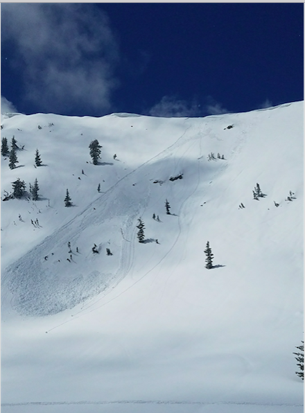
recent activity Long-running, dry sluffs in the top few inches of the snow were reported on steep aspects early Friday morning, and minor wet-loose activity was reported on solar aspects in upper Little Cottonwood on Friday afternoon. A few wind drifts in the upper elevations were also reported to be sensitive, with one small wind-slab avalanche reported from the Park City ridgeline. We also received this photo of a boarder-triggered avalanche on the backside of Clayton Peak in Big Cottonwood Canyon.
Although we will be shutting down regular operations, we will continue to post recent avalanche activity and observations through the end of April, so please do continue to send them to us. You can check the latest observations here. We also follow avalanche-related activity on Instagram - be sure to tag your photos with #utavy . |
| type | aspect/elevation | characteristics |
|---|

|

|
LIKELIHOOD
 LIKELY
UNLIKELY
SIZE
 LARGE
SMALL
TREND
 INCREASING DANGER
SAME
DECREASING DANGER
|
|
description
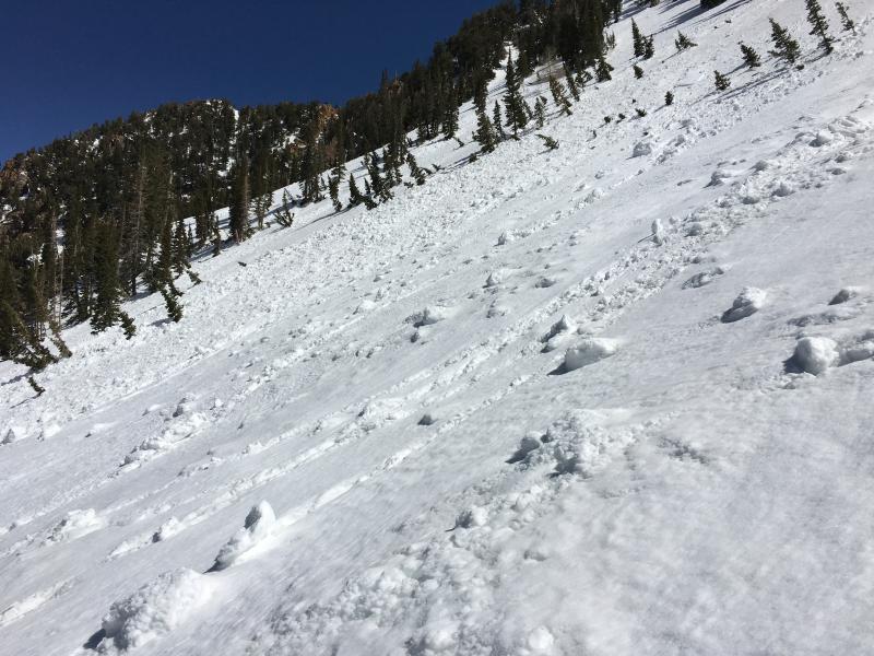
Cool temperatures and cloudy skies kept the Thursday night storm snow in check on Friday, but the storm snow will quickly become reactive once it undergoes heating from the sun, and wet loose activity is expected this weekend with clear skies and warming temperatures forecasted. It is best to get an early start, and once you see roller balls and pinwheels as - as shown in the photo below - these are bulls eye signs that the snow is starting to warm enough to become unstable. If you start seeing these signs of instability it is best to either head home or head for shady lower angle terrain with nothing steep above or adjacent to you.
|
| type | aspect/elevation | characteristics |
|---|

|
|
LIKELIHOOD
LIKELY
UNLIKELY
SIZE
LARGE
SMALL
TREND
INCREASING DANGER
SAME
DECREASING DANGER
|
|
description
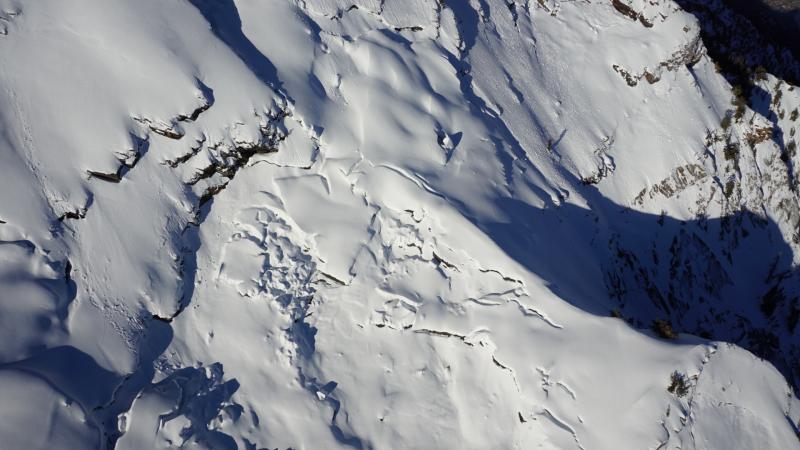
Glide Avalanches - Although lower elevations and south aspects are beginning to melt out, there is still a deep, 10' snowpack in the upper elevations. The following aerial photo from April 5 shows glide cracks in Stairs Gulch. With a deep snowpack in the alpine regions, Spring mountaineering conditions are prime right now in the Wasatch. However, certain drainages in Big Cottonwood Canyon - including Stairs Gulch, Mill B South, and Broads Fork - are also known paths for glide avalanches, and this terrain should be avoided. (We received an excellent, personalized observation discussing glide avalanches, and you can also visit Bruce Tremper's blog on glide avalanches as well.)
|
 |
weather A ridge of high pressure moves in overnight Friday. Mountain weather for this weekend: Friday Night clear with temperatures in the mid teens. W/NW winds teens gusting into the 20's mph. Saturday sunny with mountain temperatures rising into the low 40's F. E/NE winds gusting into the 20's mph Saturday Night mostly clear with temperatures upper 20's F. Sunday partly to mostly sunny, with increasing clouds later in the day with a slight chance of rain/snow showers. The upcoming week is currently forecasted to be wet and active! |
general announcements
|