25th Annual Black Diamond Fall Fundraising Party
Thursday, September 13; 6:00-10:00 PM; Black Diamond Parking Lot
25th Annual Black Diamond Fall Fundraising Party
Thursday, September 13; 6:00-10:00 PM; Black Diamond Parking Lot
| Advisory: Salt Lake Area Mountains | Issued by Evelyn Lees for Wednesday - March 22, 2017 - 6:17am |
|---|

|
bottom line The avalanche danger is MODERATE today for triggering wet loose sluffs on steep slopes of all aspects and elevations. Wet sluffs can even be triggered in the new wet snow at the upper elevations. The avalanche danger may rise to CONSIDERABLE during any periods of heavier rain today, with gullies and couloirs of all aspects producing the largest avalanches or a mix of mud and snow. The danger of cornice falls and glide avalanches will also increase during periods of rain or snow, so avoid travel beneath them.
|
 |
special announcement Spring Special: We have a few donated Snowbasin discount lift tickets left and have just lowered the price. Ski a day and benefit the Utah Avalanche Center! Order here. UAC Gear Sale Fundraiser: We still have some donated gear and certificates left over from the season. Want a guided rock climbing or canyoneering trip in Moab? How about a new pair of skis for some spring ski missions? Check out our gear sale photo album to see if we have what you need. This is a fundraising sale for the Utah Avalanche Center all proceeds benefit avalanche forecasting and education. Click here to visit the sale! |
 |
current conditions Under mostly cloudy skies, scattered light to moderate rain showers are falling through out northern Utah mountains, with the rain/snow line near 10,000’. It’s already been an “electric-morning”, with lightning occurring in some of the rain/snow squalls. The Salt Lake and Park City mountains have received 1 to 5” of wet snow up high, with over ½” of rain in a few places. Temperatures cooled in the last 6 hours, and are in the low 30s at 10,000’, but still in the mid 30s to near 40 at 8 to 9,000’. Winds are from the southwest, and averaging to 25 mph, with gusts in the 30s as the squalls pass by. |
 |
recent activity No avalanche activity was reported from the backcountry yesterday. With explosives, a Cottonwood resort released a wet sluff that broke to the ground, on a northeast-facing slope at 10,000’. Small wet loose sluffs were triggered with ski cuts. |
| type | aspect/elevation | characteristics |
|---|

|

|
LIKELIHOOD
 LIKELY
UNLIKELY
SIZE
 LARGE
SMALL
TREND
 INCREASING DANGER
SAME
DECREASING DANGER
|
|
description
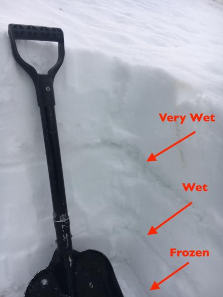
There was no meaningful refreeze of the snowpack overnight due to cloudy skies, rain and warm temperatures. Wet loose sluffs can be triggered today on all aspects and elevations, including in the newest wet snow at the upper elevations. Be especially alert for easily triggered wet sluffs and even natural avalanches if it starts raining heavily where you are. That’s when I picture the snowpack becoming “un-glued” – the last of the ice bonds melting, and the snow becoming slushy and wet loose sluffs very easy to trigger. The outlier: this is highly variable, but free water pooling above the any number of crusts, especially the February rain crusts, may produce wet slab activity in steep terrain. Control work four days ago in the Ogden mountains produced a 3' deep wet slab in unsupported terrain. I hate finding this sort of layering - water in the snowpack. My observation from Monday here.
|
| type | aspect/elevation | characteristics |
|---|

|

|
LIKELIHOOD
LIKELY
UNLIKELY
SIZE
 LARGE
SMALL
TREND
 INCREASING DANGER
SAME
DECREASING DANGER
|
|
description
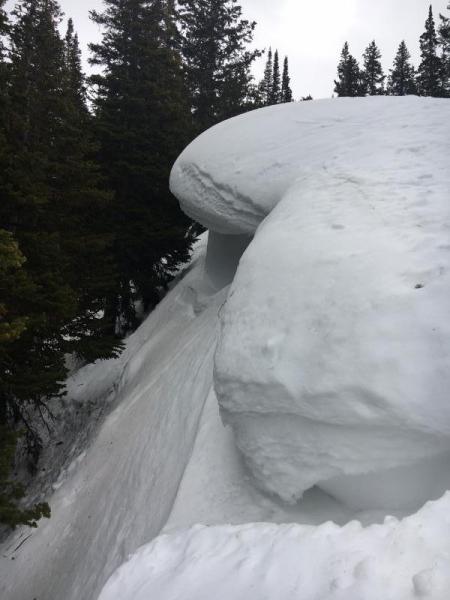
The large cornices throughout the range are sagging and dripping in the heat. Avoidance is key – don’t travel beneath them and stay well back from the edges. Cornices tend to break well back onto what looks like flat terrain. (pc: Lees)
|
| type | aspect/elevation | characteristics |
|---|
|
|
LIKELIHOOD
LIKELY
UNLIKELY
SIZE
LARGE
SMALL
TREND
INCREASING DANGER
SAME
DECREASING DANGER
|
|
description
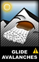
Glide cracks have opened through out the range, from Ogden south through Provo. They are most common where there are smooth rock slabs or grass beneath the snow. With today’s rain on snow event, it’s even more likely for a few of these glide avalanches to release. And when they do, it’s the entire deep snowpack coming down slope, resulting in deep debris piles. So avoid all travel below these cracks, and stay out of the run out zones. Common locations include Broads Fork, Stairs Gulch and Mill B South in Big Cottonwood Canyon, and Raymond Slabs. For photos from a recent tour into Broads and Mill B South, click here. |
 |
weather “The Great Warm-up of March 2017” is just about over. After one more day of very warm temperatures, rain and thunderstorms, some cooler air will finally arrive tonight. An additional 2 to 6” of wet snow is possible today above about 9,000’, with rain showers below, heaviest this afternoon. There is a 30% chance of lightning with these squalls. 10,000’ temperatures will remain in the low 30s, and 8,000’ temperatures warm to near 50 today. Gusty, southerly winds will increase as the squalls pass by, averaging 25 mph, with gust to 40 mph. The high ridge lines will have gusts in the 50s at times. Temperatures will drop into the 20s overnight with moderate snowfall, and about of foot of dense snow is possible by tomorrow afternoon. After a break on Friday, another cool, moist system will arrive for the weekend. |
| general announcements Remember your information can save lives. If you see anything we should know about, please help us out by submitting snow and avalanche conditions. You can also call us at 801-524-5304, email by clicking HERE, or include #utavy in your tweet or Instagram. To get help in an emergency (to request a rescue) in the Wasatch, call 911. Be prepared to give your GPS coordinates or the run name. Dispatchers have a copy of the Wasatch Backcountry Ski map. Backcountry Emergencies. It outlines your step-by-step method in the event of a winter backcountry incident. If you trigger an avalanche in the backcountry, but no one is hurt and you do not need assistance, please notify the nearest ski area dispatch to avoid a needless response by rescue teams. Thanks.
EMAIL ADVISORY If you would like to get the daily advisory by email you will need to subscribe here. DAWN PATROL Hotline updated daily by 5-530am - 888-999-4019 option 8. TWITTER Updates for your mobile phone - DETAILS UDOT canyon closures: LINK TO UDOT, or on Twitter, follow @UDOTavy, @CanyonAlerts or @AltaCentral Utah Avalanche Center mobile app - Get your advisory on your iPhone along with great navigation and rescue tools. Powderbird Helicopter Skiing - Blog/itinerary for the day Lost or Found something in the backcountry? - http://nolofo.com/ To those skinning uphill at resorts: it is critical to know the resort policy on uphill travel. You can see the uphill travel policy for each resort here. Benefit the Utah Avalanche Center when you shop from Backcountry.com or REI: Click this link for Backcountry.com or this link to REI, shop, and they will donate a percent of your purchase price to the UAC. Both offer free shipping (with some conditions) so this costs you nothing! Benefit the Utah Avalanche Center when you buy or sell on ebay - set the Utah Avalanche Center as a favorite non-profit in your ebay account here and click on ebay gives when you buy or sell. You can choose to have your seller fees donated to the UAC, which doesn't cost you a penny. This information does not apply to developed ski areas or highways where avalanche control is normally done. This advisory is from the U.S.D.A. Forest Service, which is solely responsible for its content. This advisory describes general avalanche conditions and local variations always occur. |