25th Annual Black Diamond Fall Fundraising Party
Thursday, September 13; 6:00-10:00 PM; Black Diamond Parking Lot
25th Annual Black Diamond Fall Fundraising Party
Thursday, September 13; 6:00-10:00 PM; Black Diamond Parking Lot
| Advisory: Salt Lake Area Mountains | Issued by Trent Meisenheimer for Saturday - February 18, 2017 - 4:32am |
|---|


|
bottom line The avalanche danger is Moderate on slopes that are recently wind-loaded. This terrain includes all aspects at the upper elevations. Northerly facing terrain has weak faceted snow where these slabs will be more sensitive and could be triggered at a distance. Otherwise there is a mostly Low danger where the primary avalanche concern is loose sluffs on steeper northerly aspects.
|
 |
special announcement Is your coffee still warm? if so, give Drew Hardesty's blog a read: A Companion Piece to #NothingBadHappened called Hindsight 20/40 |
 |
current conditions South winds picked up last night around the dinner hour and continue to blow this morning. Upper elevation wind speeds are 20-25 mph gusting into the 40's & 50's. Mid canyon anemometers are getting in on the action as well and recording speeds of 15-20 mph gusting into the 40's. Overnight a uniform 3" inches (0.25" h20) of new snow fell throughout the Wasatch range. Temperatures continue to be on the warmer side where mid to lower canyon trailhead temperatures are above freezing. 9000' temperatures are 27 degrees. An excellent week in Review: By Greg Gagne found HERE. |
 |
recent activity One backcountry party reported being very lucky in the Y-not couloir yesterday as wet avalanches came ripping down past them around noon hour read his observation HERE. No other significant avalanche activity was reported. |
| type | aspect/elevation | characteristics |
|---|

|

|
LIKELIHOOD
 LIKELY
UNLIKELY
SIZE
 LARGE
SMALL
TREND
 INCREASING DANGER
SAME
DECREASING DANGER
|
|
description
Today keep a keen eye out for fresh drifts of wind blown snow. The new snow overnight has fallen on a variety of different snow surfaces and will likely not bond well on, upper elevation north facing terrain where the snow was faceted, southerly sunny aspects that were crusted. Mid to lower elevations where the snow is damp it will bond well. The biggest concern - will be the upper elevation wind loaded northerly facing terrain where wind drifted snow sits above faceted snow. Any new wind drifted snow will be reactive on those aspects and could be triggered from a distance. Video from Thursday where athlete Andy Dorais found a small wind slab as he was skiing across the slope. I would expect these wind slabs to be a bit bigger today. |
| type | aspect/elevation | characteristics |
|---|

|
|
LIKELIHOOD
 LIKELY
UNLIKELY
SIZE
 LARGE
SMALL
TREND
 INCREASING DANGER
SAME
DECREASING DANGER
|
|
description
Normal Caution. Remember that risk is inherent in mountain travel. Additional avalanche concerns for the backcountry includes the following:
|
 |
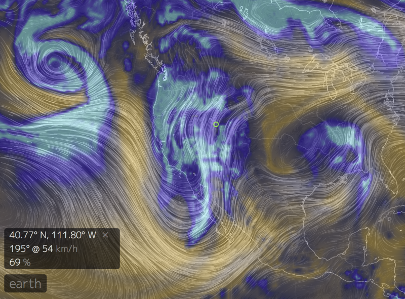
weather Today we will continue to have gusty south winds for much of the day with speeds in the 15-20 mph range across the mid elevation ridgelines. Upper elevation 10,000' and above will see speeds of 25-30 mph with gusts into the 60's. If we are lucky, we will pick up a trace to a couple inches of new snow today. Temperatures will remain warm with the rain snow line bobbing around 7000' in elevation. Upper elevation 10,000' temperatures will be in the mid 20's. Tonight and tomorrow morning will be the best chance for snow as a quick system races through. Unfortunately as you can see in the picture below, the storm is rocketing towards Baja and splitting around us. Don't be too sad just yet! - there is still a chance of 6-10 inches of new snow possible by Monday.
|
general announcements
|