25th Annual Black Diamond Fall Fundraising Party
Thursday, September 13; 6:00-10:00 PM; Black Diamond Parking Lot
25th Annual Black Diamond Fall Fundraising Party
Thursday, September 13; 6:00-10:00 PM; Black Diamond Parking Lot
| Advisory: Salt Lake Area Mountains | Issued by Evelyn Lees for Saturday - February 11, 2017 - 6:51am |
|---|

|
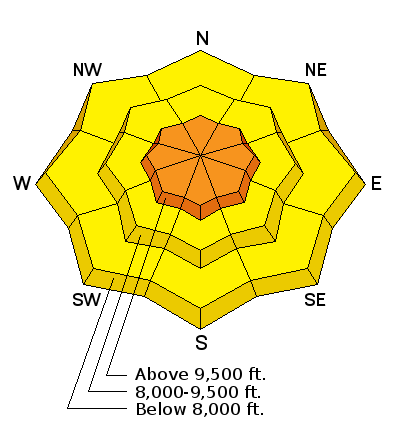
bottom line The avalanche danger is CONSIDERABLE this morning on steep upper elevation slopes in areas that have received a foot or more of new snow, where new storm snow slides can be triggered, especially any wind drifts. The danger is MODERATE in areas that received less snow, and the new snow should stabilize through out the day and become less sensitive. The avalanche danger is also MODERATE on on mid and low elevation slopes, where wet loose sluffs can be triggered on all aspects.
|
 |
special announcement Backcountry Closures – backcountry closure, 4 am 2/11 to 8 am 2/11. All North Side backcountry closed in LCC. South Side terrain from White Pine trailhead OK Wasatch Backcountry Skiing Weather: Friends of the UAC President Steve Achelis has done it again: check out his one-stop-shop page here. |
 |
current conditions In keeping with this winter’s maritime theme, the rain/snow line started at about 9000’ yesterday, rapidly dropped to around 8,000’, and then down to the benches after midnight as the cold front came through. The dense, right side up snow should provide excellent turning and riding conditions at the upper elevations. Storm totals of snow and rain:
After two days of strong southwesterly winds, speeds started to decrease yesterday afternoon as the snow came in, and really dropped as the front passed. Winds are now from the northwest and very light, less than 15 mph at most stations. To catch up on the full week, check out Greg Gagne’s weekly blog HERE. |
 |
recent activity No avalanche activity reported from the backcountry yesterday. Control work is triggering slides in Little Cottonwood this morning. Thursday night, a large natural cornice broke loose above 11,000’ in Little Cottonwood, triggering a 2-3’ deep, 100’ wide, far running slab avalanche. |
| type | aspect/elevation | characteristics |
|---|

|
|
LIKELIHOOD
 LIKELY
UNLIKELY
SIZE
 LARGE
SMALL
TREND
 INCREASING DANGER
SAME
DECREASING DANGER
|
|
description
Storm snow - Up high, the combination of “right side up” new snow (dense snow with increasingly lighter snow on top), light winds and warm temperatures is a good thing. The new storm snow will be most sensitive early this morning, with human triggered slides likely on steep slopes with about a foot or more of new snow. But the new snow should stabilize rapidly through out the day. Use small test slopes to evaluate the new snow sensitivity. Wind drifts - the winds have blown from southwest through northwest in the past 18 hours, so new drifts could be on a variety of aspects, mostly along the upper elevation ridge lines. Cornices are still an issue. Both old and new cornices are sensitive, break back further than you would expect, and breaking off one of the large cornices could trigger a new snow slide on the slope below. |
| type | aspect/elevation | characteristics |
|---|

|
|
LIKELIHOOD
 LIKELY
UNLIKELY
SIZE
LARGE
SMALL
TREND
INCREASING DANGER
SAME
DECREASING DANGER
|
|
description
After days of warm temperatures and rain on snow to over 8000’, a few hours of overnight cooling isn’t going to be a quick fix. Rain and warm temperatures have soaked and weakened the old snow, which is now hidden beneath the new snow. The new “dry” snow will act just like wet snow once you get it moving. Below around 8000’, any sluff you trigger will turn into a wet sluff – with dense, cement like debris, and even small steep terrain features such as road and creek banks can pile up enough debris to bury a person. Be very alert for changing conditions as you change elevations today. Cold dry snow up high on a slope can transition to wet loose snow over a short drop in elevation, surprising you. Daytime heating with thinning clouds or any glimpses of sun could also heat the new snow and rapidly increase its sensitivity. |
| type | aspect/elevation | characteristics |
|---|

|
|
LIKELIHOOD
 LIKELY
UNLIKELY
SIZE
LARGE
SMALL
TREND
INCREASING DANGER
SAME
DECREASING DANGER
|
|
description
We are hoping to put this one to bed soon – but it will take some fieldwork. I’m thinking the surface hoar layer became wet at the low elevations, and the most likely place to trigger a slide on it would be above around 8,000’. Again, it was mostly isolated to the low and mid elevation shady slopes at the northern end of the Park City ridgeline to Parleys Canyon. |
 |
weather As the storm moves south out of the area, the mountains should receive light snow through about noon, adding up to 2 to 4” in areas favored by northwest flow. By around noon, skies should be partly cloudy, and temperatures warm – highs in the low 30s at 8000’, and low 20s at 10,000’. The northwesterly winds should remain light all day, averaging less than 15 mph. Even the highest peaks will only gust into the 30s. High pressure will build back in on Sunday and remain through Thursday, with unseasonably warm temperatures once again by early next week. The next storm Friday looks to be another warm one. |
general announcements
|


