25th Annual Black Diamond Fall Fundraising Party
Thursday, September 13; 6:00-10:00 PM; Black Diamond Parking Lot
25th Annual Black Diamond Fall Fundraising Party
Thursday, September 13; 6:00-10:00 PM; Black Diamond Parking Lot
| Advisory: Salt Lake Area Mountains | Issued by Drew Hardesty for Sunday - January 22, 2017 - 5:28am |
|---|

|
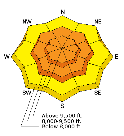
bottom line A rising CONSIDERABLE avalanche danger exists for new and old wind slabs at the mid and upper elevations. They'll be predominantly found on steep north to east to south facing slopes and up to 2' deep. Lingering storm snow avalanches may also be triggered with provocation on all aspects and elevations. Cornices should be approached with caution or not at all. Sluffing will still be possible in the steepest terrain on all aspects. With additional snow and wind, I expect the danger to rise toward HIGH overnight and into tomorrow.
|
 |
special announcement Little Cottonwood Canyon will close at 6am this morning for avalanche control work with specific backcountry closures in effect. All North side backcountry closed. South Side terrain from White Pine trailhead OK. If you sign up for AmazonSmile and designate the Utah Avalanche Center as your favorite charity, they will donate a portion of everything you spend to the UAC. I doesn't cost you a penny and we'd really appreciate the help. I'll be hosting the Fireside Chat at the Black Diamond store this Thursday at 7pm. Topic: Expert Intuition in High Risk - Low Frequency Events. Best if you have a decent grasp of the different avalanche problems, but all are welcome to this informal, low key, picnic - style gathering. |
 |
current conditions And the storms march on, a million snowflakes at a time. The weather gods indeed look fondly upon the Wasatch Range, though let's not forget how mischievous or mercurial they can be. (Skip down to Mountain Weather). Many areas picked up another trace to a couple inches overnight before the skies trended partly cloudy into the wee hours. Mountain temps are now in the low teens to upper single digits. Winds have now backed to the west southwest ahead of the next system, blowing 10-15mph with gusts to 25. 24 hour storm totals are 18" in the Cottonwoods and 8-12" along the Park City ridgeline...pushing storm (snow/snow-water-equivalent) totals to 36"/1.81" in LCC, 25"/1.43" in BCC, and 14"/1.20" in PC. Week in Review by Greg Gagne Not much to report. A dominant ridge of high pressure with clear skies and cold nights through late this past week and into Wednesday led to a weakening of the snow surface on many aspects, with several observations noting surface hoar crystals as well as near-surface facets. Winds began to increase on Wednesday night and into Thursday morning, before diminishing midday on Thursday. A weak storm system deposited 3-5" in the Salt Lake mountains on Thursday. On Wednesday, pro observer Mark White provided - as usual - an excellent observation of the snow surface prior to Thursday's small storm. Note how he highlights a thin temperature crust on west aspects that cap weaker faceted snow underneath. Observations from Thursday in the Salt Lake mountains indicated winds and warm temperatures likely destroyed the surface hoar layer ahead of the snowfall, but the layer of near-surface facets has been preserved on many shady aspects at the mid and upper elevations underneath Thursday's storm snow. |
 |
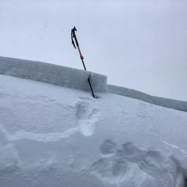
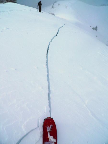
recent activity All the signs were there: natural avalanches, hair-trigger human triggered avalanches, avalanches triggered remotely, avalanches triggering avalanches, cracking, collapsing - all aspects, all elevations - you get the idea. Honestly it's been awhile since I remember it being so sensitive. All - almost all, that is, were within the new snow 4-14" deep and up to 200' wide. The exceptions - the outliers - involved intentionally ski cut storm snow or wind slabs in Summit Park of Parleys and along the Cutler Ridge of Ogden running a foot deep running on faceted snow. (Uncertain of locations? Check out Steve Achelis's Wasatch map). Pics below: Mark White, Greg Gagne (Summit Park, Neffs). Here's footage of a natural slide in Big Cottonwood: https://twitter.com/sethaweinert/status/822878967661137920/video/1 * We did hear 2nd hand of a lone backcountry skier along the Canyons Village of Park City periphery (Python area) that was caught and carried for 300'. * Another report arrived of a party of 3 in West Porter of Mill Creek Canyon that were overrun by a shallow natural from above. They temporarily lost gear but came out unscathed.
Caution!: I'm issuing another Soapbox Warning: As traffic and delays plagued the Cottonwoods, many headed for Porter Fork of Mill Creek . I received an email describing the scene: "At one point I counted 25 people all on the same slope at the same time. There were lots of dogs, people side-slipping the skin track, half lapping and quarter lapping, dropping in on people, blocking the entire width of the luge run out to de-skin and chat - perhaps a foreshadowing of the Wasatch in a few years and the best case I've seen yet for a discussion of standard acceptable behavior. " |
| type | aspect/elevation | characteristics |
|---|

|
|
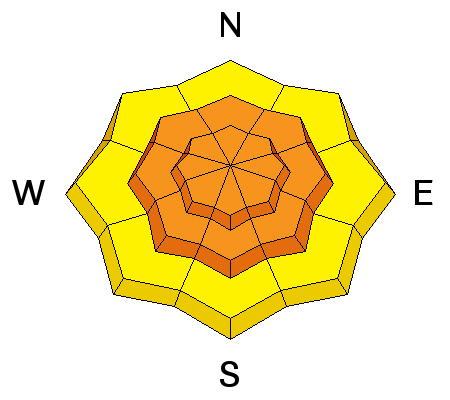
LIKELIHOOD
 LIKELY
UNLIKELY
SIZE
 LARGE
SMALL
TREND
 INCREASING DANGER
SAME
DECREASING DANGER
|
|
description
Wind slabs up to 2' thick will be sensitive to human provocation and more readily found on the steep north to east to south facing slopes. Yesterday's moderate to strong westerlies...along with today's ramping west to southwest winds will make wind drifts your primary concern. Look for smooth and rounded pillows to the lee of ridgelines and cross-loaded beyond spines and sub-ridges. Listen for the tell-tale signs of collapsing; watch for shooting cracks: both active signs from the snowpack that say Do Not Touch .
With thanks to Mark White and genius of our time Gary Larson |
| type | aspect/elevation | characteristics |
|---|

|
|
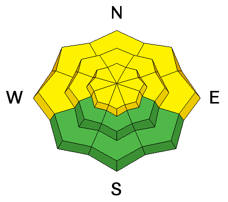
LIKELIHOOD
LIKELY
UNLIKELY
SIZE
LARGE
SMALL
TREND
INCREASING DANGER
SAME
DECREASING DANGER
|
|
description
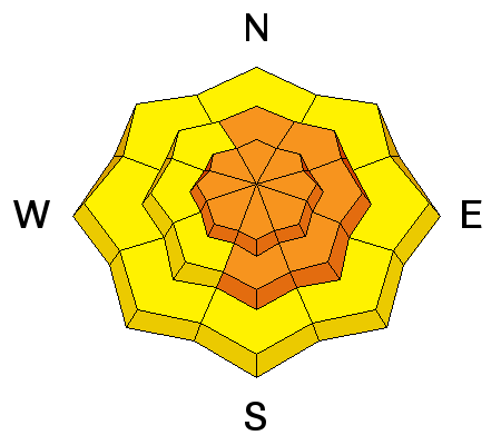
The glue has yet to dry; that is, that many interfaces and weaknesses within the storm snow failed and avalanched yesterday and the snow will need a bit more time to adjust and gain strength. Naturals are not expected within the storm snow, but human triggered slides within these "intra-storm' weaknesses will still be possible in steep terrain of all aspects and elevations. Test slopes, cornice drops, and simple snow tests should provide good information on localized instability. |
| type | aspect/elevation | characteristics |
|---|

|
|
LIKELIHOOD
 LIKELY
UNLIKELY
SIZE
 LARGE
SMALL
TREND
INCREASING DANGER
SAME
DECREASING DANGER
|
|
description
Weak surface snow (facets and patches of surface hoar), buried by myriad sun, wind, and temperature crusts lay dormant. I don't anticipate these weaknesses to be a primary player today, but if activated with enough weight (perhaps more likely with this afternoon's additional strong winds), they'll result in larger, more unmanageable avalanches. Collapsing is a sign of instability. |
 |
weather Another storm on the doorstep, but this one will be initially wet, warm and windy...with 1-2' of storm snow possible through Tuesday...with flurries through early Thursday. The southwest winds will begin in earnest by late morning and should reach sustained hourly averages of 40mph by the afternoon...and then perhaps 50mph overnight. Precipitation will start and sputter by the afternoon with only a couple inches of snow expected by dinnertime. Snowfall intensities will pick up overnight and into tomorrow with a cold front mid-morning. Today we'll have overcast skies with temps warming to the upper teens at 10,000'. |
general announcements
|