25th Annual Black Diamond Fall Fundraising Party
Thursday, September 13; 6:00-10:00 PM; Black Diamond Parking Lot
25th Annual Black Diamond Fall Fundraising Party
Thursday, September 13; 6:00-10:00 PM; Black Diamond Parking Lot
| Advisory: Salt Lake Area Mountains | Issued by Drew Hardesty for Saturday - January 14, 2017 - 5:48am |
|---|

|
bottom line A localized MODERATE danger exists in the central Wasatch Range. The danger will be most pronounced on the steepest sun-drenched terrain with daytime warming. Use extreme caution traveling along the heavily corniced ridgelines and continue to use safe travel protocol: make a plan, one at a time in steep terrain, get out of the way at the bottom. Please communicate with other parties and try to avoid being above or beneath others in our very crowded Wasatch Range.
|
 |
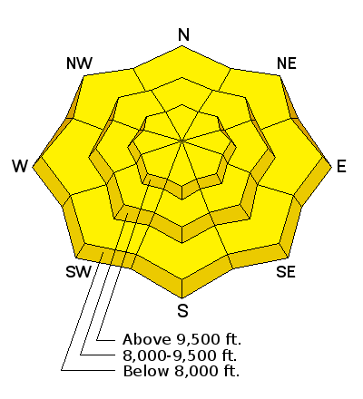
current conditions Severe clear. Winds are light from the south. Mountain temps are in the upper teens to low 20s. Skiing and riding conditions are nothing less than phenomenal. Rough storm totals since last Saturday night and totals since New Years Upper LCC: 37"/4.48"................. 72"/6.90".................... Total snow depths are 80-90" Upper BCC: 46"/4.78"............... 103"/8.46".................... Total snow depths are 80-95" PC ridgeline: 41"/4.70"............... 80"/7.4" ..................... Total snow depths are 75-85" Ogden 27"/2.5"-62"/7.95"............ 46"/3.71-83"/10.23.............. Total snow depths are 80-100" Provo 35"/3.19" ....................... 67"/5.79" ................. Total snow depths are 80-120" |
 |
recent activity No reports of avalanche activity in the backcountry per se; however, explosive testing in uncompacted terrain in upper Big Cottonwood yielded a 4-6' deep and 100' wide hard slab on a very steep and rocky east facing slope at 10,300'. Observers in upper Cardiff Fork of BCC noted a large natural from west Cardiac Bowl to south Cardiac ridge 3-5' deep and an estimated 1/2 of a mile wide...likely from Wednesday/Wednesday night. Graupel pooling beneath the cliffbands/couloir-apron transitions suspected. Report found here. Preliminary report of Wednesday's accident in the western Uintas can be found here. |
| type | aspect/elevation | characteristics |
|---|

|
|
LIKELIHOOD
 LIKELY
UNLIKELY
SIZE
 LARGE
SMALL
TREND
 INCREASING DANGER
SAME
DECREASING DANGER
|
|
description
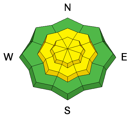
Maritime. The storm and wind slab instabilities are rapidly healing but may still be triggered with heavy loads. I see three problematic scenarios:
Hot Tip: Give the cornices a wide berth, put only one person on the steep slope at at time, and avoid the steepest sunlit terrain by late morning. Thinner snowpack areas such as Mt Aire and Lambs have a persistent slab issue with a Moderate danger at the mid to low elevations; this terrain should be approached with caution. |
| type | aspect/elevation | characteristics |
|---|

|
|
LIKELIHOOD
 LIKELY
UNLIKELY
SIZE
LARGE
SMALL
TREND
 INCREASING DANGER
SAME
DECREASING DANGER
|
|
description
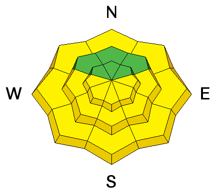
Out of towners and those from higher latitudes often underestimate the intensity of the solar radiation in Utah. Today's direct sun and heating will foster unstable conditions on the steepest south facing terrain today. While we're not seeing a rapid rise in temperature on very low density snow, I do feel that the direct sun will allow the storm snow to become damp, unstable and ripe for human triggering in the sunlit terrain and the low elevations on the north side of the compass. Rollerballs, pinwheels, and natural sluffs are key indicators for transitioning dry to wet snow. Those entering steep, confined south facing terrain in the afternoon are likely to create decent dry to wet avalanche debris piles in the runouts below. Hot Tip: Continually change terrain to seek "cooler" aspects (eg: east to south to west) that haven't seen the prolonged heating and direct sun...or avoid the steep sunlit aspects altogether. |
| type | aspect/elevation | characteristics |
|---|

|
|
LIKELIHOOD
LIKELY
UNLIKELY
SIZE
 LARGE
SMALL
TREND
INCREASING DANGER
SAME
DECREASING DANGER
|
|
description
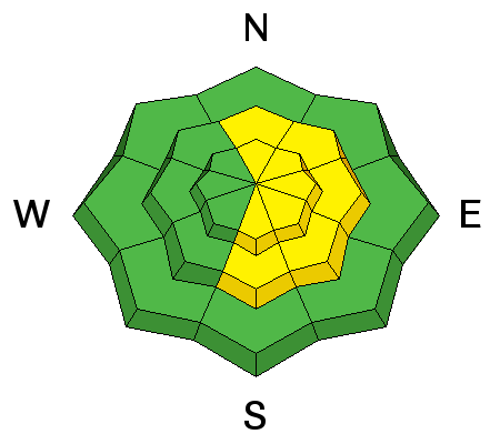
Enormous cornices litter the mid and upper elevation ridgelines and will break back well past the apex of the ridgeline. Give these monsters a very wide berth. Falling over with a breaking cornice may result in significant traumatic injury (at best) and/or provide for a sufficient trigger for an avalanche below. Hot Tip: Give these monsters a very wide berth. |
 |
weather We'll have sunny skies, light southerly winds, and temps rising to the low 20s at 10,000', the mid 30s at 8000'. This will be our first break in the storms since New Year. We're in a bit of a break until about mid week. |
general announcements
|


