25th Annual Black Diamond Fall Fundraising Party
Thursday, September 13; 6:00-10:00 PM; Black Diamond Parking Lot
25th Annual Black Diamond Fall Fundraising Party
Thursday, September 13; 6:00-10:00 PM; Black Diamond Parking Lot
| Advisory: Salt Lake Area Mountains | Issued by Evelyn Lees for Tuesday - January 3, 2017 - 6:53am |
|---|

|
bottom line The avalanche danger is CONSIDERABLE on all steep mid and upper elevation slopes, where soft slabs, wind drifts and large sluffs can be easily triggered. Natural avalanches are possible at the upper elevations where the wind in blowing and drifting the snow. Avalanches can be triggered remotely today. Anyone heading into the backcountry needs good snowpack and terrain evaluation skills and conservative decision-making. Measure your slope angles and stay off of and out from under steep slopes, especially those getting wind drifted.
|
 |
special announcement The Salt Lake City premier of The Fourth Phase from the creators of The Art of Flight will at Brewvies at 7 pm on Monday, Jan 9 as a fundraiser for the Utah Avalanche Center. For tickets and details, go to https://utahavalanchecenter.org/event/fourth-phase Brighton has amended their uphill travel plan. You can find it here - http://www.brightonresort.com/mountain/ski-patrol/brighton-resort-uphill-travel-plan/ |
 |
current conditions This storm is quite the overachiever – it produced an additional 10” of snow overnight in the Park City and Salt Lake area mountains, and storm totals are now in the 18 to 36” range. It’s light powder, containing less than 2” of water weight. Light snow is falling, temperatures are in the single digits to mid teens, and the westerly winds are averaging 10 to 15 mph. High peaks have 15 to 25 mph averages, with peak gusts in the 50s overnight. The Ogden area mountains received no snow overnight, and have a 6 to 10” storm total. The Provo area mountains have a 10 to 19” storm total. |
 |
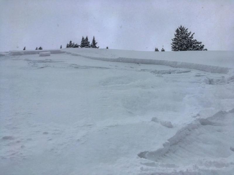
recent activity Amid widespread sluffing and soft slabs, two avalanches stand out from yesterday, perhaps precursors of what’s to come.
Mark White photos of No Name slide.
|
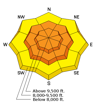
| type | aspect/elevation | characteristics |
|---|

|
|
LIKELIHOOD
 LIKELY
UNLIKELY
SIZE
 LARGE
SMALL
TREND
 INCREASING DANGER
SAME
DECREASING DANGER
|
|
description
There is a lot of new snow out there, so expect to trigger long running sluffs packing a punch and soft new snow slab avalanches today if you get onto steep terrain. These slides will run fast and far, entraining snow as they move down slope. The snow will be especially sensitive on mid and upper elevation shady slopes – there, the new snow is sitting on a layer of weak faceted snow. On these slopes, slides can be triggered remotely from a distance, you may trigger a slide mid slope, with snow releasing above you or the second or third person may trigger the slide. Check out this short little video from yesterday showing the poor bonding of the new snow to the faceted snow. Today, this weak snow is now buried 1 to 3 feet deep in places. |
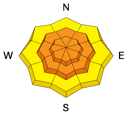
| type | aspect/elevation | characteristics |
|---|

|
|
LIKELIHOOD
 LIKELY
UNLIKELY
SIZE
LARGE
SMALL
TREND
 INCREASING DANGER
SAME
DECREASING DANGER
|
|
description
With acres of snow available for transport and upper elevation wind speeds fast enough to drift the snow, sensitive wind slabs will be found in the higher terrain. Anywhere, anytime the wind speeds increase, natural avalanches will be possible, and human triggered slides certain on wind-drifted slopes. So avoid travel on and below wind-drifted slopes. The drifts will be most widespread at the upper elevations, but evaluate mid elevation terrain carefully, too, for any signs of wind drifting. |
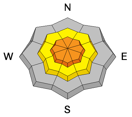
| type | aspect/elevation | characteristics |
|---|

|
|
LIKELIHOOD
 LIKELY
UNLIKELY
SIZE
 LARGE
SMALL
TREND
INCREASING DANGER
SAME
DECREASING DANGER
|
|
description
The snowpack has a variety of buried facets and crusts on mid and upper elevation slopes of all aspects, with the newest layer of facets just buried yesterday. A smaller new snow slide might be able to trigger a deeper slide in the snowpack, especially in a shallower snowpack area. Be especially wary of slopes that have slid one or more times this year, drainages with less snow, and wind scoured areas. |
 |
weather Skies will be mostly cloudy today, with a final 1 to 3” of snow possible this morning. Temperatures will warm into the low 20s at 8,000’, and mid-teens at 10,000’. The southwesterly winds will be light below about 10,000’, averaging 10 to 15 mph. Across the higher terrain, wind speeds could increase to 25 to 35 mph with gusts in the 40s and 50s. The next storm will arrive by tomorrow morning, lasting into Thursday morning, with increasing temperatures, wind and heavy dense snow. |
general announcements
|