25th Annual Black Diamond Fall Fundraising Party
Thursday, September 13; 6:00-10:00 PM; Black Diamond Parking Lot
25th Annual Black Diamond Fall Fundraising Party
Thursday, September 13; 6:00-10:00 PM; Black Diamond Parking Lot
| Advisory: Salt Lake Area Mountains | Issued by Greg Gagne for Friday - December 23, 2016 - 5:12am |
|---|


|
bottom line This morning, the avalanche danger is MODERATE at upper elevations, and LOW and mid and low elevations. As winds begin to increase this afternoon, the avalanche hazard will rise to MODERATE at mid elevations. Pay careful attention to rapidly changing avalanche conditions due to wind loading, especially during the late afternoon hours.
|
 |
special announcement Once again this winter, our partners at the Wasatch Mountain Club are matching WMC member donations to the Utah Avalanche Center. If you are a WMC member and value avalanche forecasting and education, please send a check made out to the Utah Avalanche Center to the WMC at 1390 South 1100 East #103, Salt Lake City, UT 84105 Practice avalanche rescue at the Big Cottonwood Canyon beacon park in the west end of the first entry to Solitude Mountain Resort. |
 |
current conditions Temperatures currently range from the mid teens to low 20's, and winds are out of the SW and are light at low and mid elevations. At upper elevations winds are blowing in the mid teens, with gusts in the mid 20's. The snow surface is currently quite a mixed bag with sun and temperature crusts at lower and mid elevations. There are also hard, scratchy wind slabs at the mid and upper elevations. With only about 1" of new snow from this past week, most slopes also have quite a few tracks. There are still patches of dense, settled snow on shady mid and upper elevation slopes that provide enjoyable riding conditions. |
 |
recent activity No avalanche activity was reported from Thursday. Yesterday I re-visited the site of Monday's deep slab avalanche in the Birthday Chutes area of White Pine Canyon with my touring partner Wes Johnston. Winds and light snow have already begun to change the landscape of this avalanche, and today is likely the last good opportunity to examine - and learn from - this slide. Whether you are able to visit the site or not, we encourage you to read the UAC report of this significant avalanche.
|
| type | aspect/elevation | characteristics |
|---|

|
|
LIKELIHOOD
 LIKELY
UNLIKELY
SIZE
 LARGE
SMALL
TREND
 INCREASING DANGER
SAME
DECREASING DANGER
|
|
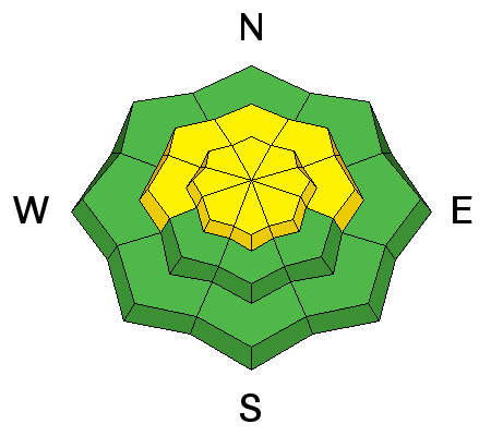
description
Although winds this morning are generally light with moderate gusts, increasing south and west winds this afternoon are likely to create fresh wind drifts and load mid and upper elevations slopes. During the morning hours any wind effected snow should be confined to the upper elevations, and the danger rose reflects the forecasted effects from the wind during the afternoon. Yesterday I found many snow surfaces to be either slick sun or temperature crusts, or old, hard wind slabs from this past Monday's SW winds. Additionally, the 1" new from Wednesday was sluffing easily on steeper slopes. All of these existing snow interfaces provide excellent bed surfaces for any fresh wind drifts to run on. |
| type | aspect/elevation | characteristics |
|---|

|
|
LIKELIHOOD
LIKELY
UNLIKELY
SIZE
 LARGE
SMALL
TREND
INCREASING DANGER
SAME
DECREASING DANGER
|
|
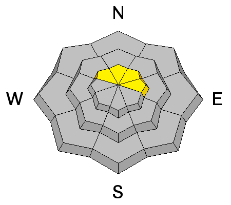
description
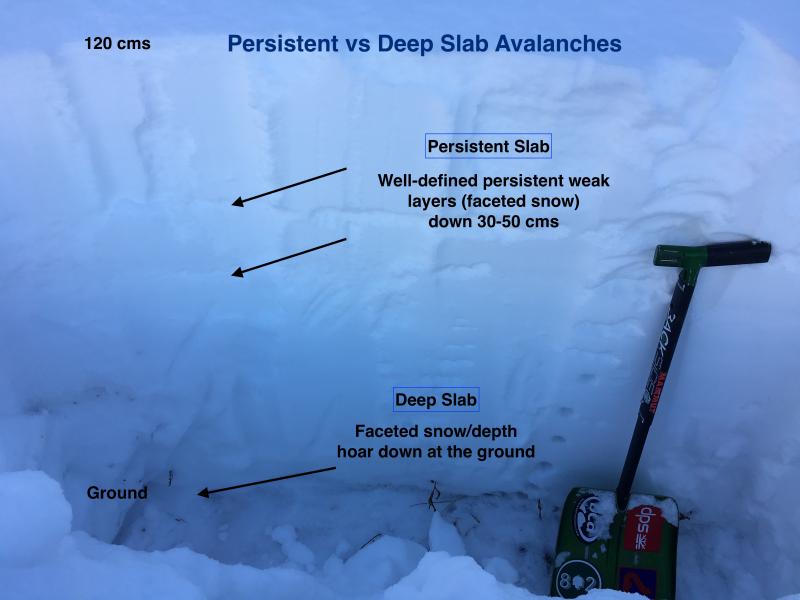
In the upper 3' of the snowpack, there are several persistent weak layers we have been watching. These layers formed during cold spells during early and mid December, creating several layers of weak, faceted snow. If you dig down with your shovel these layers are typically quite easy to identify and evaluate. Over the past seven days I have been finding these layers gaining strength and adjusting to the load of snow from last weekend, however one observation on Thursday on a NE aspect at 10200' in Cardiff Fork described these buried layers where "the facets appear to be getting weaker, and the slab stronger." Additionally, some observers are still finding layers of graupel from last Friday's cold front sandwiched between denser layers of snow. Monday's Birthday Chutes avalanche failed on a layer of facets near the ground. This deep slab avalanche was likely triggered from a thinner area, and propagated to where the crown was ~10' thick. Although this is an isolated incident, it is easy to imagine there are other northerly, upper elevation aspects that hold the same snowpack structure as was found in the Birthday Chutes. These mid-pack weaknesses, as well as faceted snow at the ground, will get loaded and stressed once again beginning later today and extending throughout the holiday weekend. The image below highlights the distinction between "persistent slab" and "deep slab" avalanches. You can read more from yesterday's fieldwork with Wes Johnston.
|
 |
weather This morning winds will remain light with moderate gusts along the ridgetops in the 20's mph. Winds do begin to increase steadily during the afternoon, and by sunset we should expect to see winds gusting to over 50 mph along the ridgetops. The below-freezing temperatures this morning will rise to the mid and upper 30's at 8K, and about 20 at 10K. Increasing and thickening clouds as the day progresses. Winds will remain strong with accumulating snowfall beginning this evening. Continued strong winds along with a cold front arriving during the day on Saturday with continuing snowfall. By the time you turn in for bed on Christmas night, the mountains could have received upwards of 2' - 3'. Be sure to visit the UAC web site for weather and avalanche updates for this significant winter storm. |
| general announcements Remember your information can save lives. If you see anything we should know about, please help us out by submitting snow and avalanche conditions. You can also call us at 801-524-5304, email by clicking HERE, or include #utavy in your tweet or Instagram. To get help in an emergency (to request a rescue) in the Wasatch, call 911. Be prepared to give your GPS coordinates or the run name. Dispatchers have a copy of the Wasatch Backcountry Ski map. Backcountry Emergencies. It outlines your step-by-step method in the event of a winter backcountry incident. If you trigger an avalanche in the backcountry, but no one is hurt and you do not need assistance, please notify the nearest ski area dispatch to avoid a needless response by rescue teams. Thanks.
EMAIL ADVISORY If you would like to get the daily advisory by email you will need to subscribe here. DAWN PATROL Hotline updated daily by 5-530am - 888-999-4019 option 8. TWITTER Updates for your mobile phone - DETAILS UDOT canyon closures: LINK TO UDOT, or on Twitter, follow @UDOTavy, @CanyonAlerts or @AltaCentral Utah Avalanche Center mobile app - Get your advisory on your iPhone along with great navigation and rescue tools. Powderbird Helicopter Skiing - Blog/itinerary for the day Lost or Found something in the backcountry? - http://nolofo.com/ To those skinning uphill at resorts: it is critical to know the resort policy on uphill travel. You can see the uphill travel policy for each resort here. Benefit the Utah Avalanche Center when you shop from Backcountry.com or REI: Click this link for Backcountry.com or this link to REI, shop, and they will donate a percent of your purchase price to the UAC. Both offer free shipping (with some conditions) so this costs you nothing! Benefit the Utah Avalanche Center when you buy or sell on ebay - set the Utah Avalanche Center as a favorite non-profit in your ebay account here and click on ebay gives when you buy or sell. You can choose to have your seller fees donated to the UAC, which doesn't cost you a penny. This information does not apply to developed ski areas or highways where avalanche control is normally done. This advisory is from the U.S.D.A. Forest Service, which is solely responsible for its content. This advisory describes general avalanche conditions and local variations always exist. |