25th Annual Black Diamond Fall Fundraising Party
Thursday, September 13; 6:00-10:00 PM; Black Diamond Parking Lot
25th Annual Black Diamond Fall Fundraising Party
Thursday, September 13; 6:00-10:00 PM; Black Diamond Parking Lot
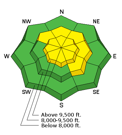
| Advisory: Salt Lake Area Mountains | Issued by Evelyn Lees for Wednesday - December 21, 2016 - 6:17am |
|---|

|
bottom line There is a widespread MODERATE avalanche danger today at the upper and mid elevations. Hard wind slabs can be triggered along the ridgelines or in open bowls and long running sluffs can be triggered on steep slopes. There is a MODERATE danger of triggering a deep slide of all the storm snow or an even deeper slide in very isolated areas that breaks to the ground, on an upper elevation northwest through easterly facing slope.
|
 |
special announcement Once again this winter, our partners at the Wasatch Mountain Club are matching WMC member donations to the Utah Avalanche Center. If you are a WMC member and value avalanche forecasting and education, please send a check made out to the Utah Avalanche Center to the WMC at 1390 South 1100 East #103, Salt Lake City, UT 84105 |
 |
current conditions It’s the first day of winter, and fittingly, light snow is falling in the mountains. Temperatures are cooling, currently in the upper teens to mid 20s. The west northwesterly winds are light, averaging less then 10 mph at most stations, with the highest peaks averaging 20 mph. There is still powder on shady wind sheltered slopes, but many ridge lines and open bowls are wind damaged, and lower elevations and southerly facing slopes sun and heat crusted. |
 |
recent activity Yesterday, wet loose sluffs were triggered in the Salt Lake and Park City area mountains on southeast through west facing slopes, some large enough to carry a person. In the windier Ogden area mountains, hard slabs were released with explosives, failing on facets or rain crusts, on mid and upper elevation slopes facing NW-SE. Preliminary information on Birthday Chute slide triggered Monday evening is posted. It failed on depth hoar on the ground, and I am stunned by the size and especially the width and the way it connected across 2 chutes. |
| type | aspect/elevation | characteristics |
|---|

|
|
LIKELIHOOD
 LIKELY
UNLIKELY
SIZE
 LARGE
SMALL
TREND
 INCREASING DANGER
SAME
DECREASING DANGER
|
|
description
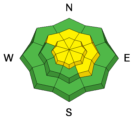
The mid and upper elevation landscape is scattered with hard wind slabs, both along ridge lines and also mid slope. These are hard slabs – a slab avalanche that will break above you, not at your feet. Slope cuts are NOT effective on these. Cracking of hard snow beneath your or a hollow, drum like feel are both signs of a hard wind slab. |
| type | aspect/elevation | characteristics |
|---|

|
|
LIKELIHOOD
 LIKELY
UNLIKELY
SIZE
 LARGE
SMALL
TREND
 INCREASING DANGER
SAME
DECREASING DANGER
|
|
description
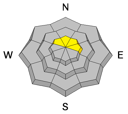
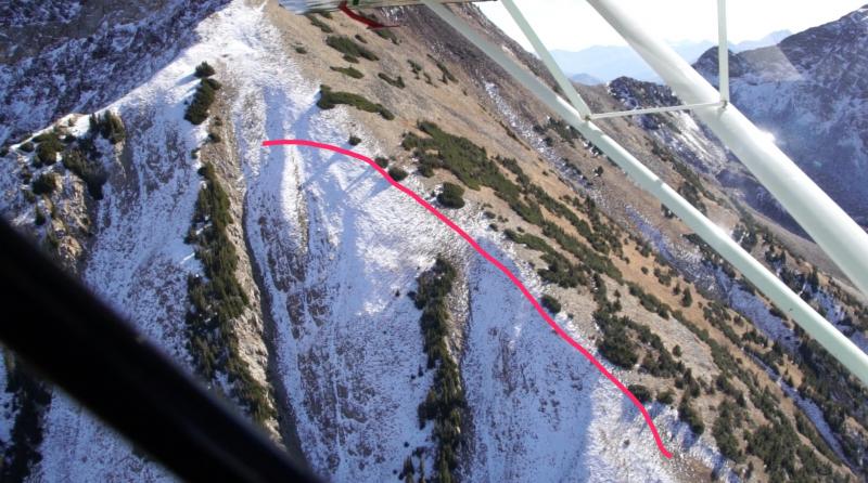
There are buried 2 layers of facets in our snowpack: The upper layer is buried 1 to 3 feet deep, and could still be triggered in a few places, taking out all the snow from last weekend’s storm, with wind-loaded slopes the most suspect. The other layer is the November facets on the ground – depth hoar, the hardest weak layer to deal with. When a slide like the Birthday Chutes surprises you, it’s time to step back and be more conservative. One has to figure, if one slide that large can be triggered, there must be a few other places with similar layering where a large avalanche could be triggered. The old faceted snow was most widespread on northwest through easterly facing slopes, at the upper elevations that held old snow from November. Left photo below was taken by Tony Pavlantos and Steve Lloyd on November 14th, showing the distribution of snow in the Birthday Chutes, red line the approximate crown. Right photo - looking up across the crown .
|
| type | aspect/elevation | characteristics |
|---|

|
|
LIKELIHOOD
 LIKELY
UNLIKELY
SIZE
LARGE
SMALL
TREND
INCREASING DANGER
SAME
DECREASING DANGER
|
|
description
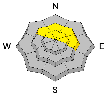
On wind sheltered, steep slopes you can trigger a loose sluff just large enough to catch and carry a person. Terrain matters here – it would be bad news if you got carried off a cliff or into a tree. Hopefully, today’s cooler temperatures will put an end to having wet sluffs in December, but the snow on low to mid elevation slopes may take time to cool, so check for damp snow, including beneath the newly frozen crusts. |
 |
weather The weak cold front stalling over northern Utah will produce light snow flurries, adding up to an inch or two of snow. Skies will remain cloudy today, with 10,000’ temperatures near 20, and 8000’ temperatures warming to near 30. The northwesterly winds may increase for a few hours this morning, averaging 10 to 15 mph, before decreasing this afternoon. High peaks could average to 25 mph. The next chance for snow is a small storm forecast for around Christmas Day. |
| general announcements Remember your information can save lives. If you see anything we should know about, please help us out by submitting snow and avalanche conditions. You can also call us at 801-524-5304, email by clicking HERE, or include #utavy in your tweet or Instagram. To get help in an emergency (to request a rescue) in the Wasatch, call 911. Be prepared to give your GPS coordinates or the run name. Dispatchers have a copy of the Wasatch Backcountry Ski map. Backcountry Emergencies. It outlines your step-by-step method in the event of a winter backcountry incident. If you trigger an avalanche in the backcountry, but no one is hurt and you do not need assistance, please notify the nearest ski area dispatch to avoid a needless response by rescue teams. Thanks.
EMAIL ADVISORY If you would like to get the daily advisory by email you will need to subscribe here. DAWN PATROL Hotline updated daily by 5-530am - 888-999-4019 option 8. TWITTER Updates for your mobile phone - DETAILS UDOT canyon closures: LINK TO UDOT, or on Twitter, follow @UDOTavy, @CanyonAlerts or @AltaCentral Utah Avalanche Center mobile app - Get your advisory on your iPhone along with great navigation and rescue tools. Powderbird Helicopter Skiing - Blog/itinerary for the day Lost or Found something in the backcountry? - http://nolofo.com/ To those skinning uphill at resorts: it is critical to know the resort policy on uphill travel. You can see the uphill travel policy for each resort here. Benefit the Utah Avalanche Center when you shop from Backcountry.com or REI: Click this link for Backcountry.com or this link to REI, shop, and they will donate a percent of your purchase price to the UAC. Both offer free shipping (with some conditions) so this costs you nothing! Benefit the Utah Avalanche Center when you buy or sell on ebay - set the Utah Avalanche Center as a favorite non-profit in your ebay account here and click on ebay gives when you buy or sell. You can choose to have your seller fees donated to the UAC, which doesn't cost you a penny.
|


 This information does not apply to developed ski areas or highways where avalanche control is normally done. This advisory is from the U.S.D.A. Forest Service, which is solely responsible for its content. This advisory describes general avalanche conditions and local variations always exist.