25th Annual Black Diamond Fall Fundraising Party
Thursday, September 13; 6:00-10:00 PM; Black Diamond Parking Lot
25th Annual Black Diamond Fall Fundraising Party
Thursday, September 13; 6:00-10:00 PM; Black Diamond Parking Lot
| Advisory: Salt Lake Area Mountains | Issued by Drew Hardesty for Monday - December 19, 2016 - 5:29am |
|---|

|
bottom line A MODERATE danger exists for longer running dry...and potentially wet loose snow avalanches...in steep terrain today. These sluffs may, in turn, pop out some lingering storm snow instabilities from our Thursday/Friday storm, resulting in a larger avalanche debris pile. Shallow pockets of wind slab or lingering storm snow avalanches are possible in extreme terrain OR if the winds pick up beyond expectations.
|
 |
special announcement Excellent stocking stuffers - Discount lift tickets for Alta, Snowbird, Brighton, Solitude, Sundance, Snowbasin, Powder Mountain, and Beaver Mountain are now available, donated by the resorts to benefit the Utah Avalanche Center. Details and order information here. These make a great holiday gift and all proceeds go towards paying for avalanche forecasting and education! Last Thursday, an avalanche came down and crossed the open road on Teton Pass, engulfing one and almost two vehicles. It was reportedly a skier-triggered avalanche. Think this won't happen here? UDOT has their job to do, but the public needs to be a part of public safety. The steep terrain above Little Cottonwood Canyon today may be prone for longer running human triggered dry and/or wet sluffs. Consider the consequences of your actions. Always be aware of current UDOT avalanche mitigation plans: follow them on Twitter @UDOTavy or Instagram. We also provide updates on our Home page and on our early morning (5am) Dawn Patrol hotline: 888-999-4019 option 8. Backcountry Responsibility Objective from Trent Meisenheimer on Vimeo. |
 |
current conditions Skies are clear; westerly winds generally less than 15mph. Mountain temps are at 24 hour highs now on the plus side of zero. They're in the mid to upper teens up high while trailheads mired in the cold dense air ride the fence on this side or that of 0°F. Skiing and riding conditions are about as good as they get. Snow depths now in the upper Cottonwoods are roughly 60"; the Park City ridgeline 40-50"; the Ogden area mountains 50-60"; the Provo area mountains 37-45". |
 |
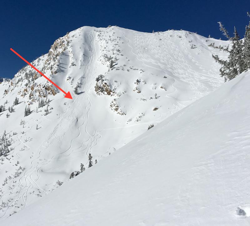
recent activity Ski area control efforts produced a few soft and hard slabs with explosives, but the backcountry scene yielded reports of only shallow loose snow avalanches.
Eye candy of some recent naturals and avalanche control work can be found here. Our forecaster in Logan Toby Weed found some amazing natural activity, particularly in the Wood Camp drainage of Logan canyon. Check it out here. |
| type | aspect/elevation | characteristics |
|---|

|
|
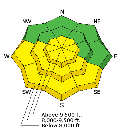
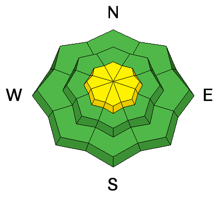
LIKELIHOOD
 LIKELY
UNLIKELY
SIZE
 LARGE
SMALL
TREND
 INCREASING DANGER
SAME
DECREASING DANGER
|
|
description
If headed to slopes approaching 40° and steeper today, plan on triggering shallow but longer running sluffs. These will be dry in the morning, but are likely to transition from dry to damp to wet sluffs in the steepest sun-lit slopes by late morning/midday. These sluffs, in turn, may pop out some still-settling storm snow slabs left-over from last Thursday/Friday's storm. As the avalanche danger diminishes, many people start moving into more aggressive terrain. The key here is that one needs to shift his/her mindset from backcountry skiiing and riding to ski-mountaineering or big mountain riding. This allows for fewer - if any - mistakes where even a small sluff that tips you off your skis or ride could have significant consequences in unforgiving terrain. I'm not saying Don't go there; I'm just offering a reminder that the margin for error narrows in this landscape. |
| type | aspect/elevation | characteristics |
|---|

|
|
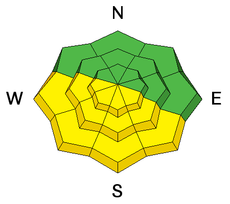
LIKELIHOOD
LIKELY
UNLIKELY
SIZE
LARGE
SMALL
TREND
INCREASING DANGER
SAME
DECREASING DANGER
|
|
description
If headed to slopes approaching 40° and steeper today, plan on triggering shallow but longer running sluffs. These will be dry in the morning, but are likely to transition from dry to damp to wet sluffs in the steepest sun-lit slopes by late morning/midday. These sluffs, in turn, may pop out some settling storm snow slabs left-over from last Thursday/Friday's storm. Damp pinwheels and rollerballs, often emanating from trees, cliff-bands or other heat-sinks, are clues to sun/heat damaged snow and it'll be time to avoid steep sunlit terrain at this time. |
| type | aspect/elevation | characteristics |
|---|

|

|
LIKELIHOOD
 LIKELY
UNLIKELY
SIZE
LARGE
SMALL
TREND
 INCREASING DANGER
SAME
DECREASING DANGER
|
|
description
Lingering storm and wind slab instabilities may be triggered still in very isolated terrain: typically very steep, unsupported terrain in the high elevations but not limited to any aspect. Mid-pack and basal instabilities seem to have gained a great deal of strength over the recent days and are unlikely to be human-triggered now but in very steep thinner snowpack areas on slopes in the high shady terrain. |
 |
weather Under sunny skies, mountain temps will rise to the mid 20s at 10,000' and near freezing at 8000'. The westerly winds are expected to blow 15-20mph along the ridgelines. We may see some high clouds streaming in by late afternoon ahead of a quick-hitting cold front for Tuesday night into Wednesday. Even the most optimistic models offer a trace to 3", but it should help mix out the inversion. Ridging follows for a couple days with another storm slated for Friday into the weekend. |
| general announcements Remember your information can save lives. If you see anything we should know about, please help us out by submitting snow and avalanche conditions. You can also call us at 801-524-5304, email by clicking HERE, or include #utavy in your tweet or Instagram. To get help in an emergency (to request a rescue) in the Wasatch, call 911. Be prepared to give your GPS coordinates or the run name. Dispatchers have a copy of the Wasatch Backcountry Ski map. Backcountry Emergencies. It outlines your step-by-step method in the event of a winter backcountry incident. If you trigger an avalanche in the backcountry, but no one is hurt and you do not need assistance, please notify the nearest ski area dispatch to avoid a needless response by rescue teams. Thanks.
EMAIL ADVISORY If you would like to get the daily advisory by email you will need to subscribe here. DAWN PATROL Hotline updated daily by 5-530am - 888-999-4019 option 8. TWITTER Updates for your mobile phone - DETAILS UDOT canyon closures: LINK TO UDOT, or on Twitter, follow @UDOTavy, @CanyonAlerts or @AltaCentral Utah Avalanche Center mobile app - Get your advisory on your iPhone along with great navigation and rescue tools. Powderbird Helicopter Skiing - Blog/itinerary for the day Lost or Found something in the backcountry? - http://nolofo.com/ To those skinning uphill at resorts: it is critical to know the resort policy on uphill travel. You can see the uphill travel policy for each resort here. Benefit the Utah Avalanche Center when you shop from Backcountry.com or REI: Click this link for Backcountry.com or this link to REI, shop, and they will donate a percent of your purchase price to the UAC. Both offer free shipping (with some conditions) so this costs you nothing! Benefit the Utah Avalanche Center when you buy or sell on ebay - set the Utah Avalanche Center as a favorite non-profit in your ebay account here and click on ebay gives when you buy or sell. You can choose to have your seller fees donated to the UAC, which doesn't cost you a penny.
|


 This information does not apply to developed ski areas or highways where avalanche control is normally done. This advisory is from the U.S.D.A. Forest Service, which is solely responsible for its content. This advisory describes general avalanche conditions and local variations always exist.