25th Annual Black Diamond Fall Fundraising Party
Thursday, September 13; 6:00-10:00 PM; Black Diamond Parking Lot
25th Annual Black Diamond Fall Fundraising Party
Thursday, September 13; 6:00-10:00 PM; Black Diamond Parking Lot
| Advisory: Salt Lake Area Mountains | Issued by Mark Staples for Thursday - December 15, 2016 - 7:04am |
|---|

|
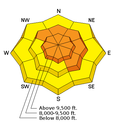
bottom line Today, conditions are complex and tricky. There are many possible avalanche problems and the easiest solution is to simply avoid avalanche terrain by riding slopes less than 30 degrees in steepness and not connected to any steeper slopes. We're in a holding pattern as a major storm approaches the area. The avalanche danger should start rising late this afternoon and tonight when rain and snow will be falling. With very strong winds, the avalanche danger is CONSIDERABLE at upper elevation and wind loaded mid elevation slopes. With storm snow, wet snow, and persistent slab avalanche problems, the danger is MODERATE on non-wind loaded mid elevation slopes and all low elevation slopes.
|
 |
avalanche watch THE FOREST SERVICE UTAH AVALANCHE CENTER IN SALT LAKE CITY HAS ISSUED A BACKCOUNTRY AVALANCHE WATCH. * TIMING…IN EFFECT FROM 9 AM MST THIS MORNING TO 6 AM MST FRIDAY * AFFECTED AREA…FOR THE MOUNTAINS OF NORTHERN UTAH INCLUDING THE WASATCH RANGE...BEAR RIVER RANGE...UINTA MOUNTAINS...AND THE MANTI-SKYLINE AND WASATCH PLATEAU. * AVALANCHE DANGER…THE AVALANCHE DANGER FOR THESE AREAS WILL BE RISING AND COULD BE HIGH WITHIN THE NEXT 24 HOURS. * IMPACTS…POTENTIAL HEAVY SNOW COMBINED WITH WIND WILL LIKELY CREATE WIDESPREAD AREAS OF UNSTABLE SNOW. BOTH HUMAN TRIGGERED AND NATURAL AVALANCHES ARE LIKELY. STAY OFF OF AND OUT FROM UNDER SLOPES STEEPER THAN 30 DEGREES. THIS WARNING DOES NOT APPLY TO SKI AREAS WHERE AVALANCHE HAZARD REDUCTION MEASURES ARE PERFORMED. |
 |
special announcement TONIGHT - Thursday December 15, 6 p.m. at Snowbird's Wildflower Lounge - Utah Adventure Journal hosts local ski guide, John Mletschnig as he gives a presentation about his traverse of the Wasatch Range. More Details HERE. Discount lift tickets for Alta, Snowbird, Brighton, Solitude, Sundance, Snowbasin, Powder Mountain, and Beaver Mountain are now available, donated by the resorts to benefit the Utah Avalanche Center. Details and order information here. These make a great holiday gift and all proceeds go towards paying for avalanche forecasting and education! |
 |
current conditions This morning it’s warm and windy with temperatures in the mid to low 30’s F at all elevations. Southwest winds are blowing 20-30 mph and gusting to 40 mph. At 11,000 ft winds are gusting 70 to 80 mph. Yesterday in the Cottonwood Canyons, 5-7 inches of snow (0.5-0.7 inches of snow water equivalent, SWE) fell with more in upper Big Cottonwood where up to an inch of SWE was recorded. Along the Park City Ridgeline, 3-4 inches of snow fell (0.3 -0.4 inches of SWE). HEADS UP: With very strong winds, very warm temperatures, some rain, and some snow, there are many possible avalanches problems today. Conditions will be changing rapidly today through Saturday. To be honest, I’m not really sure what to expect, but a good rule of thumb is that weird weather creates weird avalanches. Now is a good time to be very conservative. Personally I would be patient, avoid avalanche terrain, and see what happens over the next few days. |
 |
recent activity Yesterday there were many avalanches breaking 6-8 inches deep with some in wind loaded areas up to a foot deep. What’s surprising is that some of these shallow slides fractured several hundred feet wide. These slides failed on a variety of layers that include graupel, low density snow, possibly some weak facets, and ice crusts on southerly aspects. There were no avalanches reported breaking deeper in old snow.
|
| type | aspect/elevation | characteristics |
|---|

|
|
LIKELIHOOD
 LIKELY
UNLIKELY
SIZE
 LARGE
SMALL
TREND
 INCREASING DANGER
SAME
DECREASING DANGER
|
|
description
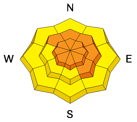
Yesterday’s avalanche activity + new snow + today’s strong winds is a simple recipe for more avalanches today near ridgetops or any place with wind drifted snow. One snow safety professional commented this morning that this wind, snow, and warm temperatures are perfect for building large cornices which could be very sensitive today. Some may break on their own. |
| type | aspect/elevation | characteristics |
|---|

|
|
LIKELIHOOD
 LIKELY
UNLIKELY
SIZE
 LARGE
SMALL
TREND
INCREASING DANGER
SAME
DECREASING DANGER
|
|
description
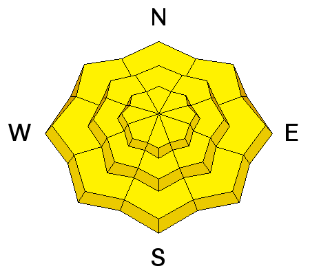
Because the new snow rest on a variety of surfaces, in some non-wind loaded areas you may still trigger storm slab avalanches 6-8 inches deep. On Tuesday in Big Cottonwood Canyon, Evelyn and I both noticed some faceting at the snow surface from clear weather on Monday. On southerly facing slopes these facets may exists under an ice crust. Below 8000 feet, very warm temperatures and/or rain this afternoon may produce loose wet snow avalanches. I don’t expect these to be very big but it will be something to watch for. |
| type | aspect/elevation | characteristics |
|---|

|
|
LIKELIHOOD
 LIKELY
UNLIKELY
SIZE
LARGE
SMALL
TREND
INCREASING DANGER
SAME
DECREASING DANGER
|
|
description
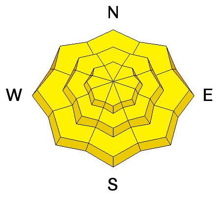
If the near surface conditions of the snowpack aren’t complicated enough, there is a mixed bag of conditions deeper in the snowpack that could cause persistent slab avalanches. Isolated slopes have a layer of weak facets at the ground while many other slope have a layer of facets in the middle of the snowpack. While yesterday’s snow hasn’t provided enough weight and stress on these layers to cause widespread avalanches, the possibility remains. Additionally, with a major storm coming tonight these layers may come to life in coming days and produce large avalanches. |
 |
weather Today will remain warm and windy with temperatures near freezing and southwest winds blowing 20-40 mph. Skies will be cloudy. Late this afternoon rain will fall below 8000 feet with snow falling about that elevation. By tomorrow morning there could be 8-12 inches of new snow with more coming. For more details on the weather click HERE for a more detailed discussion of weather that will be posted by 8 a.m. |
| general announcements Remember your information can save lives. If you see anything we should know about, please help us out by submitting snow and avalanche conditions. You can also call us at 801-524-5304, email by clicking HERE, or include #utavy in your tweet or Instagram. To get help in an emergency (to request a rescue) in the Wasatch, call 911. Be prepared to give your GPS coordinates or the run name. Dispatchers have a copy of the Wasatch Backcountry Ski map. Backcountry Emergencies. It outlines your step-by-step method in the event of a winter backcountry incident. If you trigger an avalanche in the backcountry, but no one is hurt and you do not need assistance, please notify the nearest ski area dispatch to avoid a needless response by rescue teams. Thanks.
EMAIL ADVISORY If you would like to get the daily advisory by email you will need to subscribe here. DAWN PATROL Hotline updated daily by 5-530am - 888-999-4019 option 8. TWITTER Updates for your mobile phone - DETAILS UDOT canyon closures: LINK TO UDOT, or on Twitter, follow @UDOTavy, @CanyonAlerts or @AltaCentral Utah Avalanche Center mobile app - Get your advisory on your iPhone along with great navigation and rescue tools. Powderbird Helicopter Skiing - Blog/itinerary for the day Lost or Found something in the backcountry? - http://nolofo.com/ To those skinning uphill at resorts: it is critical to know the resort policy on uphill travel. You can see the uphill travel policy for each resort here. Benefit the Utah Avalanche Center when you shop from Backcountry.com or REI: Click this link for Backcountry.com or this link to REI, shop, and they will donate a percent of your purchase price to the UAC. Both offer free shipping (with some conditions) so this costs you nothing! Benefit the Utah Avalanche Center when you buy or sell on ebay - set the Utah Avalanche Center as a favorite non-profit in your ebay account here and click on ebay gives when you buy or sell. You can choose to have your seller fees donated to the UAC, which doesn't cost you a penny.
|


 This information does not apply to developed ski areas or highways where avalanche control is normally done. This advisory is from the U.S.D.A. Forest Service, which is solely responsible for its content. This advisory describes general avalanche conditions and local variations always exist.