25th Annual Black Diamond Fall Fundraising Party
Thursday, September 13; 6:00-10:00 PM; Black Diamond Parking Lot
25th Annual Black Diamond Fall Fundraising Party
Thursday, September 13; 6:00-10:00 PM; Black Diamond Parking Lot
| Advisory: Salt Lake Area Mountains | Issued by Mark Staples for Wednesday - November 30, 2016 - 6:39am |
|---|

|
bottom line For today the avalanche danger is generally MODERATE with the exception of upper elevation, northerly aspects with a CONSIDERABLE danger where a deep persistent slab avalanche problem exists. Instabilities in the storm snow are gaining strength and the odds of triggering this type of slide are decreasing. Unfotunatley the odds of triggering a deep, persistent slab avalanche will not improve for some time.
|
 |
special announcement Big Cottonwood Canyon Road and Backcountry Closure: UDOT is conducting an Artillery Site in in Broads Fork and Stairs Gulch. The road and the backcountry in these areas will be closed. More info and a map of the affected areas HERE. Please read, please share with others - UAC/UDOT Comms plan: New Avalanche Explosives Work Backcountry Closure Procedures Going Into Effect |
 |
current conditions This morning temperatures are in the single digits F and winds are blowing 5-10 mph from the W with gusts of 15 mph. Yesterday had NW winds blowing similar speeds and under mostly cloudy skies, temperatures only reached the high teens and low 20's F. With little wind, cloudy skies, and cold temperatures, great powder can be found on many slopes. Below is a summary of storm totals from Saturday through Tuesday morning from weather stations at 9200-9500 feet. Little Cottonwood: 40" (2.74" of water) Big Cottonwood: 33" (2.43" of water) - 46" (3.29" of water) PC ridgeline: 35" (2.30" of water) Ogden mountains: 28" (2.59" of water) at 8000' and 8500' Provo mountains: 25" (2.05" of water) at 7500' |
 |
recent activity Yesterday in Little Cottonwood Canyon (LCC), explosive work triggered several avalanches 2-4 feet deep mostly on high elevation, north aspects. These slides broke on facets at the ground. Additionally there was one natural avalanche observed by ski patrollers on a north facing slope at 10,700 feet which also broke on facets near the ground and likely occurred Monday night or early Tuesday morning. One outlier was a slide in LCC triggered in old snow by explosives on a high elevation west facing slope. Otherwise, many observers in the backcountry spotted evidence of slides that occurred Monday afternoon during heavy snowfall. Most of these slides were about a foot deep and only breaking within the storm snow. |
| type | aspect/elevation | characteristics |
|---|

|
|
LIKELIHOOD
 LIKELY
UNLIKELY
SIZE
 LARGE
SMALL
TREND
 INCREASING DANGER
SAME
DECREASING DANGER
|
|
description
There are several subtle density changes in the new snow where avalanches could break. Most observations indicate that this instability is quickly healing. Yesterday in Grizzly Gulch, Evelyn and I found a slightly softer layer of snow about a foot deep that would break easily in stability test but wouldn't propagate or produce cracks which is a good sign. We felt that any place where the new snow was a bit more cohesive or wind affected, you could trigger a small soft slab avalanche. The good news is that winds shifted from NW to W overnight, but have not increased and shouldn't be transporting any more snow. The other good news is that this type of instability is easy to assess with small test slopes and slope cuts. |
| type | aspect/elevation | characteristics |
|---|

|
|
LIKELIHOOD
 LIKELY
UNLIKELY
SIZE
 LARGE
SMALL
TREND
 INCREASING DANGER
SAME
DECREASING DANGER
|
|
description
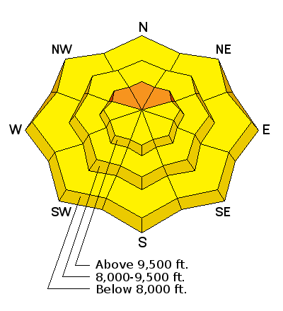
A dangerous, deep persistent slab avalanche problem exists on upper elevation North facing slopes or any slope that had old snow earlier this month. Yesterday Evelyn and I went hunting for weak faceted snow at the ground that causes this problem. We found it on a north facing slope at 9990' in Grizzly Gulch in Little Cottonwood Canyon near Twin Lakes Pass. While digging our snow pit, we got a huge collapse which is a major red flag. If we had been on a steeper slope, we would have triggered an avalanche 4 feet deep (snow profile HERE). Explosive triggered avalanches and one natural avalanche in Little Cottonwood Canyon on this layer of facets at the ground confirm this instability. Twin Lakes Pass from Trent Meisenheimer on Vimeo. Check out this video with aerial footage to get a sense of where this layer exists. It is mostly on NW, N, and NE aspects above 9500 feet and seems to be more prevalent in upper LIttle Cottonwood Canyon which recevied more early season snow than other areas. HOWEVER, I would avoid all upper elevation northly aspects in all areas unless you dig to the ground to confirm this layer is not present. |
 |
weather Lingering moisture today will keep skies cloudy this morning with some snowflakes in the air but no accumulation. Skies will become partly sunny with temperatures reaching the low to mid 20's F. Winds will continue from the West blowing 10-15 mph. By tomorrow winds will shift to the NW bringing colder air and a more moisture which should only produce a few inches of snow. |
| general announcements Remember your information can save lives. If you see anything we should know about, please help us out by submitting snow and avalanche conditions. You can also call us at 801-524-5304, email by clicking HERE, or include #utavy in your tweet or Instagram. To get help in an emergency (to request a rescue) in the Wasatch, call 911. Be prepared to give your GPS coordinates or the run name. Dispatchers have a copy of the Wasatch Backcountry Ski map. Backcountry Emergencies. It outlines your step-by-step method in the event of a winter backcountry incident. If you trigger an avalanche in the backcountry, but no one is hurt and you do not need assistance, please notify the nearest ski area dispatch to avoid a needless response by rescue teams. Thanks.
EMAIL ADVISORY If you would like to get the daily advisory by email you will need to subscribe here. DAWN PATROL Hotline updated daily by 5-530am - 888-999-4019 option 8. TWITTER Updates for your mobile phone - DETAILS UDOT canyon closures: LINK TO UDOT, or on Twitter, follow @UDOTavy, @CanyonAlerts or @AltaCentral Utah Avalanche Center mobile app - Get your advisory on your iPhone along with great navigation and rescue tools. Powderbird Helicopter Skiing - Blog/itinerary for the day Lost or Found something in the backcountry? - http://nolofo.com/ To those skinning uphill at resorts: it is critical to know the resort policy on uphill travel. You can see the uphill travel policy for each resort here. Benefit the Utah Avalanche Center when you shop from Backcountry.com or REI: Click this link for Backcountry.com or this link to REI, shop, and they will donate a percent of your purchase price to the UAC. Both offer free shipping (with some conditions) so this costs you nothing! Benefit the Utah Avalanche Center when you buy or sell on ebay - set the Utah Avalanche Center as a favorite non-profit in your ebay account here and click on ebay gives when you buy or sell. You can choose to have your seller fees donated to the UAC, which doesn't cost you a penny.
|


 This information does not apply to developed ski areas or highways where avalanche control is normally done. This advisory is from the U.S.D.A. Forest Service, which is solely responsible for its content. This advisory describes general avalanche conditions and local variations always exist.