| Please join us at the 23rd annual Black Diamond Fall Fundraiser Party Thursday Sept 15. Tickets are on sale now here, at the Black Diamond store & at REI. Special bonus raffle for online ticket purchasers! |
| Please join us at the 23rd annual Black Diamond Fall Fundraiser Party Thursday Sept 15. Tickets are on sale now here, at the Black Diamond store & at REI. Special bonus raffle for online ticket purchasers! |
| Advisory: Salt Lake Area Mountains | Issued by Greg Gagne for Friday - April 29, 2016 - 6:03pm |
|---|

|
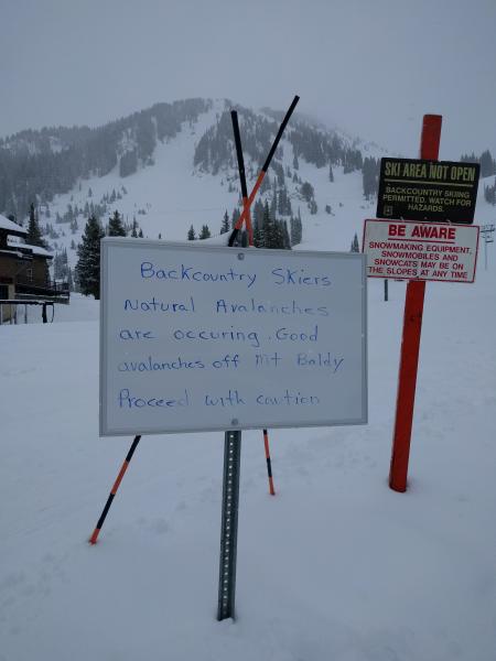
bottom line We customarily do not issue danger ratings at this point in the season, but rather provide snow and general avalanche information and weather forecasts. For Saturday and Sunday, dangerous avalanche conditions may exist due to (1) loose wet avalanches as well as (2) damp or wet slabs as the snow warms. The warming of the snow can occur with direct sun, but also with overcast skies due to greenhousing. Both loose wet as well as wet slab avalanches can be managed by using early starts and finishes to avoid the effects of heating. Once you see visible signs such as rollerballs or wet, sloppy snow, it is time to get off of and out from underneath any steep slopes. The Wasatch mountains - particularly Little Cottonwood Canyon - received a significant amount of new snow this week, so avalanches have the potential to be large and run long distances. Closed ski areas are no longer doing any control work, and travel should be treated no differently than skiing the backcountry. This photo was taken at the base of Alta Ski Area this past week.
|
 |
special announcement This is the last advisory for the 2015/16 season and will cover Saturday April 30 and Sunday May 1. We will post an end of season message the week of May 1. We will continue to post observations as we receive them over the next few weeks. We may also update conditions via Twitter or Instagram. If you see anything you feel we should know about, please submit an observation. |
 |
current conditions It has been quite a stormy week. According to Jim Steenburgh's infamous "Wasatch Weather Weenies" site, in terms of water, the week of April 25 was the biggest storm cycle of the season with nearly 4.5" of water equivalent at the Snowbird SNOTEL site:
|
 |
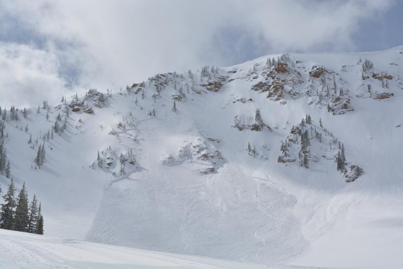
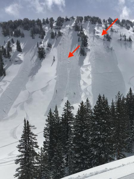
recent activity The abundant storm snow over the past week resulted in numerous human-triggered and natural avalanches, with Wednesday April 27 a particularly active day.
Thanks to everyone who is continuing to send in observations. Click HERE for the complete avalanche list, which gets updated each day. We received one observation showing a graph of accident and avalanche occurrences in 2016 using reports from the UAC site. This data is incomplete, but it does highlight that Wednesday April 27th was an especially active day for reported avalanches, although I suspect there were many more than nine avalanches that occurred that day. The full observation can be found HERE.
|
| type | aspect/elevation | characteristics |
|---|

|

|
LIKELIHOOD
 LIKELY
UNLIKELY
SIZE
 LARGE
SMALL
TREND
 INCREASING DANGER
SAME
DECREASING DANGER
|
|
description
Although the weekend weather mountain weather forecast calls for partly to mostly cloudy skies and somewhat cool temperatures, any period of warming will trigger loose wet sluffs at all aspects and elevations. Given the large amounts of storm snow we have received this past week, these slides may be significant entraining a large amount of snow and running long distances. |
| type | aspect/elevation | characteristics |
|---|

|

|
LIKELIHOOD
LIKELY
UNLIKELY
SIZE
LARGE
SMALL
TREND
INCREASING DANGER
SAME
DECREASING DANGER
|
|
description
Many observations from this past week reported several different layers within the storm snow including graupel and density changes. These layers were active during the midweek stormy period, but have settled out since. However, once the sun does come out, damp slabs and/or wet slabs will be possible on all aspects and elevations as the snow heats. These slides have the potential to be large and run long distances. |
 |
weather Partly to mostly cloud skies are expected over the weekend with overnight temperatures in the 20's, and rising into the 30's and 40's during the daytime. Winds will be light to moderate and out of the north/northeast. Upper elevations may pick up a trace to even a few inches of snow on Saturday and Sunday. |
general announcements
|