| Please join us at the 23rd annual Black Diamond Fall Fundraiser Party Thursday Sept 15. Tickets are on sale now here, at the Black Diamond store & at REI. Special bonus raffle for online ticket purchasers! |
| Please join us at the 23rd annual Black Diamond Fall Fundraiser Party Thursday Sept 15. Tickets are on sale now here, at the Black Diamond store & at REI. Special bonus raffle for online ticket purchasers! |
| Advisory: Salt Lake Area Mountains | Issued by Evelyn Lees for Wednesday - April 27, 2016 - 6:34pm |
|---|

|
bottom line We customarily do not issue danger ratings at this point in the season, but rather provide snow and general avalanche information and weather forecasts. For Thursday and Friday, new snow slabs will be the primary avalanche concern, both dry snow and heat related “damp” slabs. The second avalanche issue will be both natural and easily triggered wet snow sluffs and perhaps wet slabs if the sun comes out for any period of time, or clouds thin. Use early starts and finishes to avoid the heating, or head to lower angle terrain once the snow warms. Closed ski areas are no longer doing any control work, and travel should be treated no differently than skiing the backcountry.
|
 |
special announcement We will continue to issue intermittent advisories through the remainder of the month as conditions warrant – the next update is planned for Friday night or early Saturday morning. We will continue to post observations each day, as they are especially important to the backcountry community this time of year. We may also update conditions via Twitter or Instagram. If you see anything you feel we should know about, please submit an observation. |
 |
current conditions One to two feet of snow has fallen over the past four days in the Salt Lake and Ogden area mountains, with significantly less to the south. 10,000’ temperatures are reasonably cool - warming into the low 30s each day, cooling into the 20s at night. Turning and riding conditions at the upper elevations are very good in dense, creamy powder, especially on the northerly facing slopes. However, even short glimpses of the strong spring sun almost instantly dampen the snow on many aspects and elevations, which then crusts. |
 |
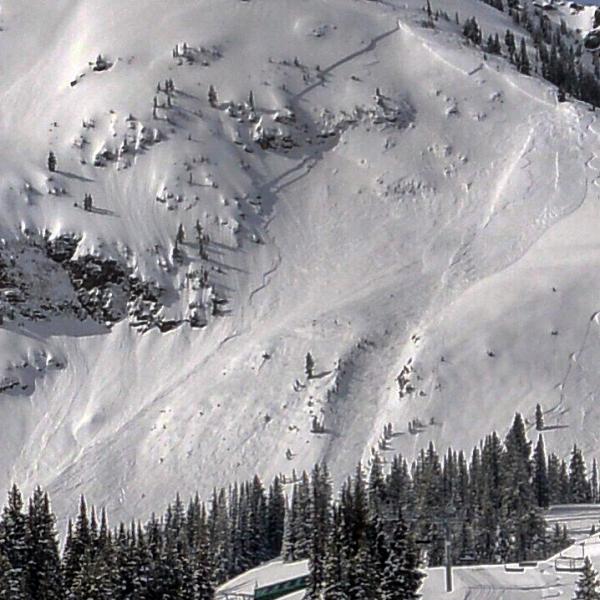
recent activity Wednesday was quite the active day, with both natural and human triggered slides. Some sluffs and slides involved just the overnight snow; a few deeper slab avalanches look like they took out snow from the past two storms. Thanks to everyone who is continuing to send in observations. Click HERE for the complete avalanche list, which gets updated each day. Intentional slope cuts triggered this slide on Baldy shoulder, LCC. (Mark White photo)
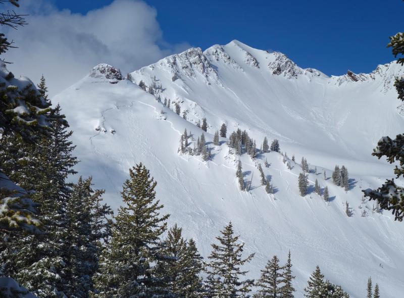
Below, natural avalanche cycle, Cardiff Fork, Dave Kikkert photo |
| type | aspect/elevation | characteristics |
|---|

|

|
LIKELIHOOD
 LIKELY
UNLIKELY
SIZE
 LARGE
SMALL
TREND
 INCREASING DANGER
SAME
DECREASING DANGER
|
|
description
Each new layer of snow has been sensitive this week, especially when it first warms with sun or daytime heating. If we get another descent shot of snow, expect another round of easily triggered soft slabs Thursday and/or Friday. Also, a few slides in the steepest terrain could break out deeper, taking out several days’ worth of storms.
Winds are forecast to remain light through Friday morning, but be alert for drifting snow if speeds happen to increase where you are, and avoid the drifts on steep slopes. |
| type | aspect/elevation | characteristics |
|---|

|
|
LIKELIHOOD
LIKELY
UNLIKELY
SIZE
LARGE
SMALL
TREND
INCREASING DANGER
SAME
DECREASING DANGER
|
|
description
Wet Loose sluffs – it will be possible to trigger wet loose sluffs each day as the surface snow heats, on almost all aspects and elevations. Natural avalanches will be possible with prolonged sun, so avoid travel beneath steep, heating slopes. “Damp” or wet slab avalanches – each time the new snow heats, it becomes sensitive, and slides easy to trigger, and may have a combination of dry and wet characteristics. |
 |
weather The stormy, cool pattern will continue, with periods of light to moderate snowfall tonight through Friday morning. 4 to 8” of snow is possible tonight, with another 2 to 4” Thursday into Friday. So about 6 to 12” of new snow is expected at the upper elevations by Friday morning. Winds are forecast to remain light from an easterly direction tonight through most of Friday, and temperatures cool, in the low 30s at 10,000’. Light snow is possible again on Saturday. |
general announcements
|