| Please join us at the 23rd annual Black Diamond Fall Fundraiser Party Thursday Sept 15. Tickets are on sale now here, at the Black Diamond store & at REI. Special bonus raffle for online ticket purchasers! |
| Please join us at the 23rd annual Black Diamond Fall Fundraiser Party Thursday Sept 15. Tickets are on sale now here, at the Black Diamond store & at REI. Special bonus raffle for online ticket purchasers! |
| Advisory: Salt Lake Area Mountains | Issued by Evelyn Lees for Saturday - April 9, 2016 - 6:32am |
|---|

|
bottom line The avalanche danger is LOW today, but unstable snow can be found on isolated terrain features. It may be possible to trigger a wet loose sluff on low to mid elevation slopes. There is also an isolated chance of triggering a wet slab avalanche or having a glide avalanche release.
|
 |
special announcement End of the season: Sunday, April 10th, will be our last regular early morning up date for the 2015-2016 winter season. We will continue to do weather-dependent intermittent updates through the month of April, and continue to post your observations on a daily basis. Your observations will become increasingly important to the backcountry community. On Friday, April 15 at 5 pm, a memorial for Doug Green, who died in an avalanche on Gobblers Knob on January 21, will be held at Our Lady of the Snows at Alta.
|
 |
current conditions Under partly cloudy skies, 10,000’ temperatures are in the low to mid 30s, about 3 to 5 degrees cooler than yesterday morning. Low elevation temperatures are warmer though, in the 40s. Winds are from the southeast, and averaging 10 to 20 mph, with gusts 20 to 35 mph. There should be a good refreeze of the snow surface at the upper elevations, and beware of slipping and going for a long ride on the hard icy surfaces. Yesterday, crusts were slow to warm due to clouds and wind, and finding corn may be tricky again today. |
 |
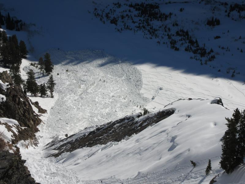
recent activity There was a report of collapsing yesterday of the thin melt freeze crust, continuing a trend of collapsing this week. Also, earlier this week, large glide avalanches released in Stairs and Broads Fork and glide cracks have been reported from low in Cutler Basin. Recent Broads Fork glide avalanche, Matt Primomo photo
|
| type | aspect/elevation | characteristics |
|---|

|

|
LIKELIHOOD
 LIKELY
UNLIKELY
SIZE
 LARGE
SMALL
TREND
 INCREASING DANGER
SAME
DECREASING DANGER
|
|
description
Even with LOW danger, travel in snow covered alpine terrain always has some risk….
It may be possible to trigger a wet sluff today on steep low to mid elevation slopes, including the northerly facing and treed slopes, which had a poor to no overnight refreeze. Clouds and wind should help keep the snowpack cool at the mid to upper elevations today. Even more isolated would be the chance of triggering a wet slab avalanche, where a frozen crust fails on wet snow beneath. Any collapsing or bending of the crust where you are means poor layering, and time to get off steep slopes. Glide avalanches continue to be a wild card – large releases occurred this week in Broads Fork and Stairs Gulch, where smooth rock slabs underlie the snowpack. Release is random, so avoid travel below any glide cracks. |
 |
weather A series of weak storm systems moving across the desert southwest will bring scattered rain and snow showers to northern Utah this afternoon into the night, with a 20% chance of lightning. Skies will be partly to mostly cloudy today, with 10,000’ temperatures in the low to mid 30s and 8000’ temperatures in the upper 40s. This puts the rain/snow line between 9 and 10,000’, though only a trace to 2” of snow is expected. The southerly winds will average 10 to 20 mph, with gusts in the 30 to 35 mph range. Temperatures will be slightly cooler Sunday, with the chance of rain and snow showers more isolated. |
| general announcements Remember your information can save lives. If you see anything we should know about, please help us out by submitting snow and avalanche conditions. You can also call us at 801-524-5304, email by clicking HERE, or include #utavy in your tweet or Instagram. To get help in an emergency (to request a rescue) in the Wasatch, call 911. Be prepared to give your GPS coordinates or the run name. Dispatchers have a copy of the Wasatch Backcountry Ski map. Backcountry Emergencies. It outlines your step-by-step method in the event of a winter backcountry incident. If you trigger an avalanche in the backcountry, but no one is hurt and you do not need assistance, please notify the nearest ski area dispatch to avoid a needless response by rescue teams. Thanks.
EMAIL ADVISORY If you would like to get the daily advisory by email you will need to subscribe here. DAWN PATROL Hotline updated daily by 5-530am - 888-999-4019 option 8. TWITTER Updates for your mobile phone - DETAILS UDOT canyon closures: LINK TO UDOT, or on Twitter, follow @UDOTavy, @CanyonAlerts or @AltaCentral Utah Avalanche Center mobile app - Get your advisory on your iPhone along with great navigation and rescue tools. Powderbird Helicopter Skiing - Blog/itinerary for the day Lost or Found something in the backcountry? - http://nolofo.com/ To those skinning uphill at resorts: it is critical to know the resort policy on uphill travel. You can see the uphill travel policy for each resort here. Benefit the Utah Avalanche Center when you shop from Backcountry.com or REI: Click this link for Backcountry.com or this link to REI, shop, and they will donate a percent of your purchase price to the UAC. Both offer free shipping (with some conditions) so this costs you nothing! Benefit the Utah Avalanche Center when you buy or sell on ebay - set the Utah Avalanche Center as a favorite non-profit in your ebay account here and click on ebay gives when you buy or sell. You can choose to have your seller fees donated to the UAC, which doesn't cost you a penny. This information does not apply to developed ski areas or highways where avalanche control is normally done. This advisory is from the U.S.D.A. Forest Service, which is solely responsible for its content. This advisory describes general avalanche conditions and local variations always exist. |