| Please join us at the 23rd annual Black Diamond Fall Fundraiser Party Thursday Sept 15. Tickets are on sale now here, at the Black Diamond store & at REI. Special bonus raffle for online ticket purchasers! |
| Please join us at the 23rd annual Black Diamond Fall Fundraiser Party Thursday Sept 15. Tickets are on sale now here, at the Black Diamond store & at REI. Special bonus raffle for online ticket purchasers! |
| Advisory: Salt Lake Area Mountains | Issued by Evelyn Lees for Monday - April 4, 2016 - 6:34am |
|---|

|
bottom line The avalanche danger is MODERATE this morning, but will rise to CONSIDERABLE danger with daytime heating. Both human triggered and natural avalanches are possible on all aspects and elevations, including northerly facing slopes, as the snow heats. Avoid travel on and below steep slopes once the snow heats up.
|
 |
special announcement On April 8-9 the Adventure Gear Expo, Utah’s largest interactive adventure festival and outdoor gear sale for the public, will be at the South Town Expo Center in Sandy highlighting 100+ local and national retailers, manufacturers and non-profits in active outdoor sports, outdoor photography and adventure travel. If you buy tickets online using the promo code GOUAC, you will get a $2 discount and they will donate $2 to the UAC.
|
 |
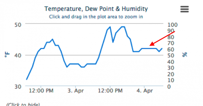
current conditions Under clear skies, temperatures at most mountain stations remained above freezing over night. So the crusty surface refreeze you’ll find early this morning is very superficial. Winds are light, with all stations averaging less than 10 mph. 48 hour temperature graph from Mill D North, 8967' showing the no overnight refreeze for the second night in a row.
|
 |
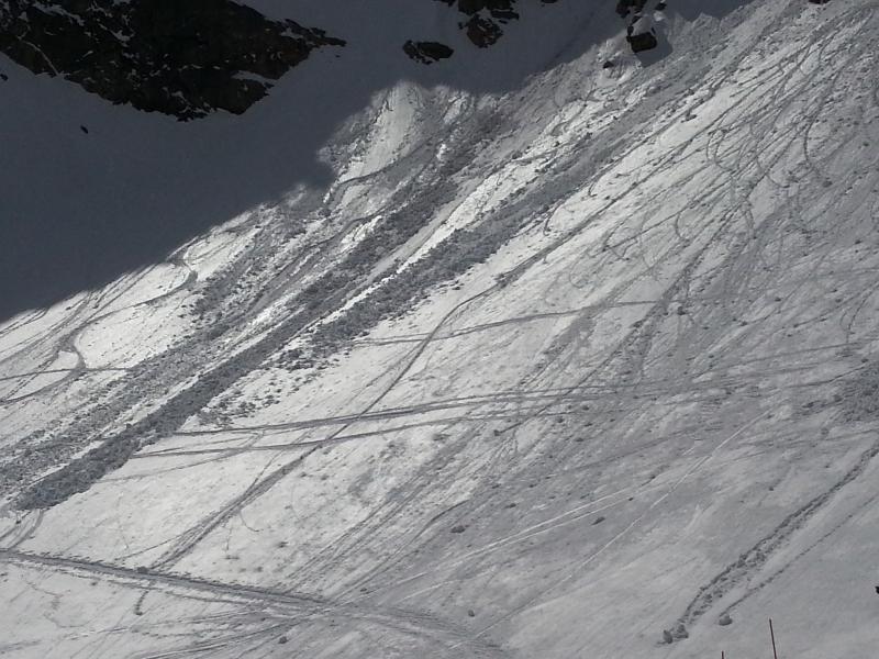
recent activity Yesterday, for the third day in a row, there were the predictable wet loose sluffs – both natural and human triggered, on almost all aspects. Natural wet loose sluffs were reported from Thurston peak, Mary Ellen Gulch, Tuscarora, and the Snowbasin backcountry, and they were certainly large enough to catch and carry a person. Of interest - several of the slides released while the slopes were in the shade – the snow is staying hot even when the sun moves off of it.
Roller balls and wet loose sluffs, Ogden area mountains, Bill Hunt photo. Thurston Peak, natural sluff, NE facing, 8600’, (sled tracks are old), J Mletschnig photo.
|
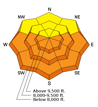
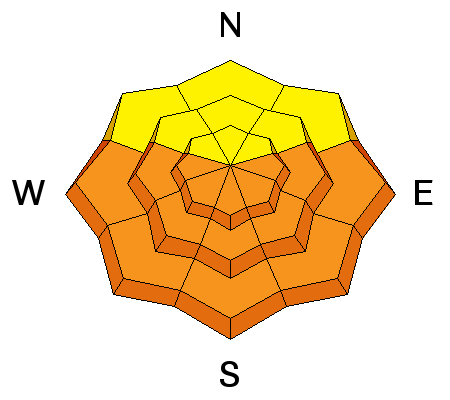
| type | aspect/elevation | characteristics |
|---|

|
|
LIKELIHOOD
 LIKELY
UNLIKELY
SIZE
 LARGE
SMALL
TREND
 INCREASING DANGER
SAME
DECREASING DANGER
|
|
description
The overnight refreeze will be very short lived this morning – the thin frozen crusts will soften rapidly, and the surface snow will become damp to wet on all aspects and elevations today, including upper elevation northerly facing. It will be easy to trigger slow moving wet loose sluffs, with the consistency of wet concrete. The snowpack is layered like an onion - slopes that have slid in the past few days could slide again, as a newly exposed inner layer of snow heats up.
Also, the snowpack is still in the transition from winter to spring at the mid and upper elevations, so other heat related issues to be aware of: Wet slabs are a possibility today… the snowpack becomes increasingly unpredictable with prolonged periods of above freezing temperatures. Several large collapses occurred yesterday below 8,000’ on southeasterly facing slope on Thurston Peak – a warning sign for wet slab activity.
Cornices are sensitive – avoid travel beneath them, and stay back further from the edge than you think you need to.
Glide avalanches – avoid travel below glide cracks, mostly occuring on slopes underlain by smooth rock slabs. Known areas include Stair Gulch, Broads Fork, Mill B, and Mineral Slabs, and the areas of smooth rock slabs in the Ogden area mountains. |
 |
weather A weak storm system will clip northern Utah today, bringing a build up of convective clouds and a few scattered rain and snow showers. 10,000’ temperatures will only drop a few degrees this afternoon, into the mid 30s, leaving the rain/snow line near 9,000’. The southwesterly winds will pick up this afternoon – with averages of 10 to 20 mph at the mid elevations, and 20 to 30 mph along the highest ridgelines. There is a 20% chance of lightning. A second dry, but colder front will cross northern Utah early tomorrow morning, dropping 10,000’ temperatures into the mid 20s. |
| general announcements Remember your information can save lives. If you see anything we should know about, please help us out by submitting snow and avalanche conditions. You can also call us at 801-524-5304, email by clicking HERE, or include #utavy in your tweet or Instagram. To get help in an emergency (to request a rescue) in the Wasatch, call 911. Be prepared to give your GPS coordinates or the run name. Dispatchers have a copy of the Wasatch Backcountry Ski map. Backcountry Emergencies. It outlines your step-by-step method in the event of a winter backcountry incident. If you trigger an avalanche in the backcountry, but no one is hurt and you do not need assistance, please notify the nearest ski area dispatch to avoid a needless response by rescue teams. Thanks.
EMAIL ADVISORY If you would like to get the daily advisory by email you will need to subscribe here. DAWN PATROL Hotline updated daily by 5-530am - 888-999-4019 option 8. TWITTER Updates for your mobile phone - DETAILS UDOT canyon closures: LINK TO UDOT, or on Twitter, follow @UDOTavy, @CanyonAlerts or @AltaCentral Utah Avalanche Center mobile app - Get your advisory on your iPhone along with great navigation and rescue tools. Powderbird Helicopter Skiing - Blog/itinerary for the day Lost or Found something in the backcountry? - http://nolofo.com/ To those skinning uphill at resorts: it is critical to know the resort policy on uphill travel. You can see the uphill travel policy for each resort here. Benefit the Utah Avalanche Center when you shop from Backcountry.com or REI: Click this link for Backcountry.com or this link to REI, shop, and they will donate a percent of your purchase price to the UAC. Both offer free shipping (with some conditions) so this costs you nothing! Benefit the Utah Avalanche Center when you buy or sell on ebay - set the Utah Avalanche Center as a favorite non-profit in your ebay account here and click on ebay gives when you buy or sell. You can choose to have your seller fees donated to the UAC, which doesn't cost you a penny. This information does not apply to developed ski areas or highways where avalanche control is normally done. This advisory is from the U.S.D.A. Forest Service, which is solely responsible for its content. This advisory describes general avalanche conditions and local variations always exist. |