| Please join us at the 23rd annual Black Diamond Fall Fundraiser Party Thursday Sept 15. Tickets are on sale now here, at the Black Diamond store & at REI. Special bonus raffle for online ticket purchasers! |
| Please join us at the 23rd annual Black Diamond Fall Fundraiser Party Thursday Sept 15. Tickets are on sale now here, at the Black Diamond store & at REI. Special bonus raffle for online ticket purchasers! |
| Advisory: Salt Lake Area Mountains | Issued by Greg Gagne for Friday - April 1, 2016 - 5:27am |
|---|

|
bottom line LOW hazard this morning, rising to MODERATE as the sun warms the snow surface. The change from Low to Moderate may occur very quickly - so be aware of rapidly changing conditions.
|
 |
special announcement Thanks for all the generous donations from the Love Utah/Give Utah fundraising event towards the Utah Avalanche Center. Your donations help us with issuing avalanche advisories, outreach, and education. All part of our mission to keep you on top of the greatest snow on earth! Congratulations to retired UAC forecaster Tom Kimbrough on the publication of "A Slidepath Runs Through It" - which describes his nearly 50 year career as a ski patroller and snow safety worker. I especially appreciated reading Tom's stories as he developed the first avalanche forecast program for his home state of Tennessee. |
 |
current conditions Temperatures are currently in the teens and winds are out of the north/northwest, blowing in the teens with gusts in the 20's mph. Skies are clear. >> A few inches of snow fell during the day on Thursday, and despite the fog obscuring visibility, excellent ski conditions were reported. Yesterday I was finding about 12" of dense, settled storm snow in Days Fork. >> Many snow surfaces dampened yesterday afternoon, and are likely to be crusted this morning at lower and mid elevations. Upper elevation north aspects were soft and dry yesterday, and I am expecting them to remain so for today. >> The northerly winds have been blowing overnight and have likely drifted upper elevation southerly aspects, with some possible cross loading onto northerly aspects as well. I suspect these drifts are shallow and not that widespread, and easily manageable with ski cuts. Snow totals for March at the Alta Guard station were 67". Although this is less than the 71 year average for March of 81", it was double the amount of snow received in February.
Review of Snow and Weather from this past week: The weekend was highlighted by a glide avalanche that released in Broads Fork on Saturday with the debris covering recent tracks. On Monday, a storm moved in to the region, with high precipitation rates and a south/southeast wind leading to sensitive avalanche conditions as well as some natural avalanche activity on Monday and especially Tuesday. The primary weak layer was the new snow/storm snow interface. The S/SE flow (unusual for us) put down the greatest snow amounts in upper Big Cottonwood Canyon as well as along the Park City ridgeline, with storm totals of 16-24" in the Cottonwoods and 18" along the Park City ridgeline. By Wednesday, conditions had stabilized, however one notable avalanche within storm snow was reported from Depth Hoar Bowl in Millcreek Canyon. Thursday brought a few inches of snow to the Cottonwoods, and was otherwise quiet apart from loose, natural avalanches on some steep, north-facing couloirs in Little Cottonwood Canyon. |
 |
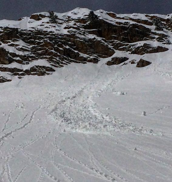
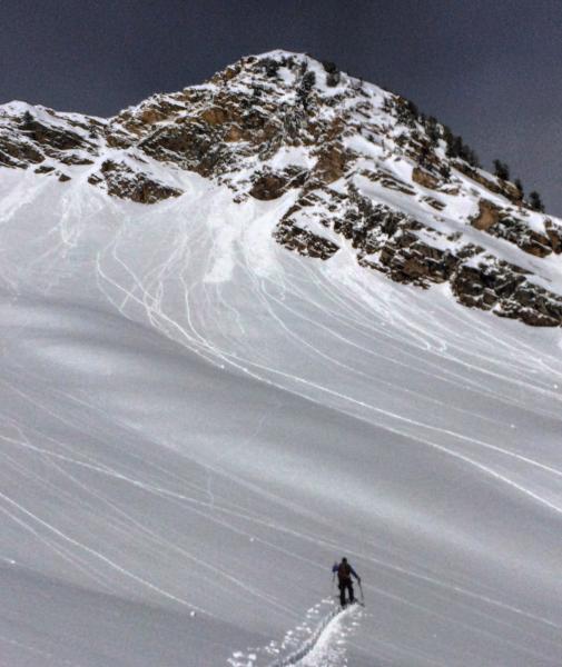
recent activity Other than damp rollerballs, the only avalanche activity reported from Thursday were loose, natural avalanches coming down from the steep, north-facing Y and Y-Not Couloirs in Little Cottonwood Canyon. |
| type | aspect/elevation | characteristics |
|---|---|

|

|
LIKELIHOOD
 LIKELY
UNLIKELY
SIZE
 LARGE
SMALL
TREND
 INCREASING DANGER
SAME
DECREASING DANGER
|
|
description
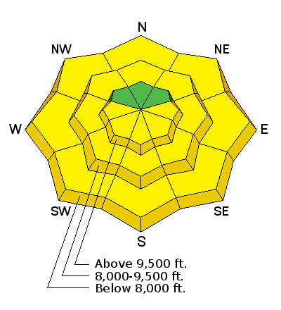
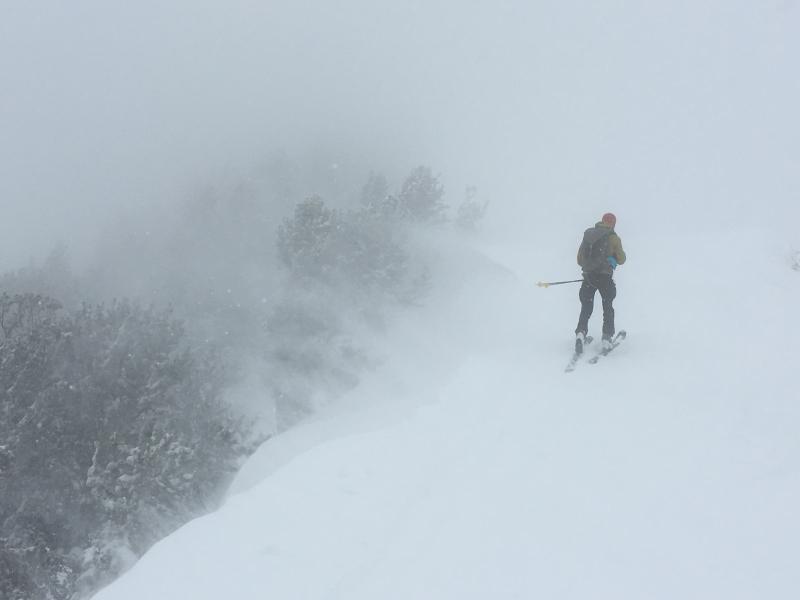
The greatest concern for today and this coming weekend is heat-related activity. Temperatures aren't expected to be all that warm today, and the winds will help keep the snow surface cool. But once the sun comes out I expect the snow surface to quickly become active with rollerballs and loose wet snow. Wet, natural activity is certain on all solar aspects, and lower and some mid-elevation north aspects are likely to be active as well. Any wind drifted snow from northerly winds overnight may also become sensitive as it warms. The storm snow from this past week is sitting on top of thick crusts on east, south, and west aspects which may provide an easy bed surface for wet slides to run on. The forecasted Moderate hazard could easily become Considerable on steep, sunny aspects. Fortunately, wet avalanche activity is very easy to identify and manage: signs of instability include pinwheels and rollerballs. Be sure to get off of and out from underneath snow surfaces as they warm today. I am expecting upper elevation northerly aspects to remain soft and dry today, which should provide good ski conditions in generally safe terrain. Pay attention for wet activity in lower elevation north aspects, particularly if you are exiting during the afternoon hours. [Photos of wet, loose natural activity and rollerballs: Mark White]
|
 |
weather Temperatures will be in the low 40's F at 8000', and just below freezing at 10000'. Winds will be from the north and blowing in the teens with gusts in the 20's mph at 10000', although wind speeds are expected to diminish throughout the day. Skies will be clear this morning, and partly cloudy along the peak tops in the afternoon. Warming conditions throughout the weekend as a ridge moves overhead. Promising signs of a storm on about Tuesday/Wednesday of this week, but with a current discrepancy in the different models, it is too hard to place much faith in the forecast at this point. |
| general announcements Remember your information can save lives. If you see anything we should know about, please help us out by submitting snow and avalanche conditions. You can also call us at 801-524-5304, email by clicking HERE, or include #utavy in your tweet or Instagram. To get help in an emergency (to request a rescue) in the Wasatch, call 911. Be prepared to give your GPS coordinates or the run name. Dispatchers have a copy of the Wasatch Backcountry Ski map. Backcountry Emergencies. It outlines your step-by-step method in the event of a winter backcountry incident. If you trigger an avalanche in the backcountry, but no one is hurt and you do not need assistance, please notify the nearest ski area dispatch to avoid a needless response by rescue teams. Thanks.
EMAIL ADVISORY If you would like to get the daily advisory by email you will need to subscribe here. DAWN PATROL Hotline updated daily by 5-530am - 888-999-4019 option 8. TWITTER Updates for your mobile phone - DETAILS UDOT canyon closures: LINK TO UDOT, or on Twitter, follow @UDOTavy, @CanyonAlerts or @AltaCentral Utah Avalanche Center mobile app - Get your advisory on your iPhone along with great navigation and rescue tools. Powderbird Helicopter Skiing - Blog/itinerary for the day Lost or Found something in the backcountry? - http://nolofo.com/ To those skinning uphill at resorts: it is critical to know the resort policy on uphill travel. You can see the uphill travel policy for each resort here. Benefit the Utah Avalanche Center when you shop from Backcountry.com or REI: Click this link for Backcountry.com or this link to REI, shop, and they will donate a percent of your purchase price to the UAC. Both offer free shipping (with some conditions) so this costs you nothing! Benefit the Utah Avalanche Center when you buy or sell on ebay - set the Utah Avalanche Center as a favorite non-profit in your ebay account here and click on ebay gives when you buy or sell. You can choose to have your seller fees donated to the UAC, which doesn't cost you a penny. This information does not apply to developed ski areas or highways where avalanche control is normally done. This advisory is from the U.S.D.A. Forest Service, which is solely responsible for its content. This advisory describes general avalanche conditions and local variations always exist. |


