| Please join us at the 23rd annual Black Diamond Fall Fundraiser Party Thursday Sept 15. Tickets are on sale now here, at the Black Diamond store & at REI. Special bonus raffle for online ticket purchasers! |
| Please join us at the 23rd annual Black Diamond Fall Fundraiser Party Thursday Sept 15. Tickets are on sale now here, at the Black Diamond store & at REI. Special bonus raffle for online ticket purchasers! |
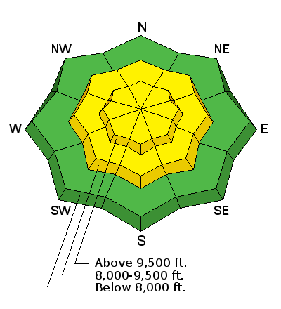
| Advisory: Salt Lake Area Mountains | Issued by Drew Hardesty for Tuesday - March 22, 2016 - 5:53am |
|---|

|
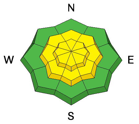
bottom line The danger will rise in lock-step with today's storm. I'd expect an overall MODERATE danger with perhaps occasional spikes to CONSIDERABLE during times of higher snowfall rates or gusty winds. Plan for longer running sluffs than usual and wind drifts in the high lee of ridges and terrain features. The best and safest riding today will be on lower angle slopes. With actively moving snow today, be mindful of who's below you. Be mindful of what terrain you're below.
|
 |
special announcement Spring powder special! We have reduced the price of donated Snowbasin lift tickets to $50, half of window price. Take advantage of blower powder on a fat snowpack and benefit the Utah Avalanche Center at the same time. http://goo.gl/ZBG44W |
 |
current conditions Snowfall began at 3am. Lighting and thunder followed at 4:30. Graupel all the while. Wind shift. Winds veering to the west northwest, blowing 15-20, gusting to 30. Cold front. Temperatures dropping now into the mid-20s. Dusk Patrol may be most appropriate for today. Let the snow pile up and settle out. 6am snow totals are 2-3"/.23". Ogden mountains are 4-6"/.46" so far. Best and safest would be to recreate on low angle terrain to avoid bottoming out on the hard crusts below the new snow. |
| type | aspect/elevation | characteristics |
|---|

|
|
LIKELIHOOD
 LIKELY
UNLIKELY
SIZE
 LARGE
SMALL
TREND
 INCREASING DANGER
SAME
DECREASING DANGER
|
|
description
On the one hand - one might imagine that warm snow coming in on warn snow surfaces might bond fairly well. On the other - graupel - much less any type of snow crystals - falling on the many slick hard crusts I found yesterday may not bond so well. (Particularly with high snowfall rates.) There are very few secrets with sluffing. (Click on the 'i' next to the infographic for more info.) Sluffing - aka - point releases or loose dry snow avalanches will be most pronounced at the mid and upper elevations where we receive more snowfall, may run naturally with higher rates of snowfall, and tend to respond well to ski cuts and other provocation. Note that they'll need slopes approaching 40° in steepness. I do expect, however, for these to perhaps run fast and far and pack a punch on the steepest sustained slopes, in particular because of the slick underlying melt-freeze crusts. |
| type | aspect/elevation | characteristics |
|---|

|
|
LIKELIHOOD
 LIKELY
UNLIKELY
SIZE
LARGE
SMALL
TREND
 INCREASING DANGER
SAME
DECREASING DANGER
|
|
description
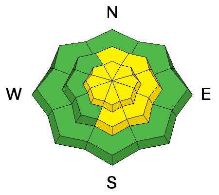
As of 6am, winds have fallen off into the light category, generally blowing less than 15mph. The weather models, however, suggest that the west and northwest winds should be 20-25mph for the day. Plan for drifting, particularly on the steep north to east to south facing slopes and sensitive to human weight while the wind's blowing. Test slopes, ski cuts, and cornice drops should provide reasonable indication of localized stability. |
 |
weather Good orographics and cold air aloft should keep snow going for most of the day with snow totals in the 8-14" range. Winds are expected to blow 20-25mph from the west northwest. Temps along the ridgelines should dive to the mid-teens. Models suggest another storm for Friday and perhaps into the weekend. |
| general announcements Remember your information can save lives. If you see anything we should know about, please help us out by submitting snow and avalanche conditions. You can also call us at 801-524-5304, email by clicking HERE, or include #utavy in your tweet or Instagram. To get help in an emergency (to request a rescue) in the Wasatch, call 911. Be prepared to give your GPS coordinates or the run name. Dispatchers have a copy of the Wasatch Backcountry Ski map. Backcountry Emergencies. It outlines your step-by-step method in the event of a winter backcountry incident. If you trigger an avalanche in the backcountry, but no one is hurt and you do not need assistance, please notify the nearest ski area dispatch to avoid a needless response by rescue teams. Thanks.
EMAIL ADVISORY If you would like to get the daily advisory by email you will need to subscribe here. DAWN PATROL Hotline updated daily by 5-530am - 888-999-4019 option 8. TWITTER Updates for your mobile phone - DETAILS UDOT canyon closures: LINK TO UDOT, or on Twitter, follow @UDOTavy, @CanyonAlerts or @AltaCentral Utah Avalanche Center mobile app - Get your advisory on your iPhone along with great navigation and rescue tools. Powderbird Helicopter Skiing - Blog/itinerary for the day Lost or Found something in the backcountry? - http://nolofo.com/ To those skinning uphill at resorts: it is critical to know the resort policy on uphill travel. You can see the uphill travel policy for each resort here. Benefit the Utah Avalanche Center when you shop from Backcountry.com or REI: Click this link for Backcountry.com or this link to REI, shop, and they will donate a percent of your purchase price to the UAC. Both offer free shipping (with some conditions) so this costs you nothing! Benefit the Utah Avalanche Center when you buy or sell on ebay - set the Utah Avalanche Center as a favorite non-profit in your ebay account here and click on ebay gives when you buy or sell. You can choose to have your seller fees donated to the UAC, which doesn't cost you a penny. This information does not apply to developed ski areas or highways where avalanche control is normally done. This advisory is from the U.S.D.A. Forest Service, which is solely responsible for its content. This advisory describes general avalanche conditions and local variations always exist. |


