| Please join us at the 23rd annual Black Diamond Fall Fundraiser Party Thursday Sept 15. Tickets are on sale now here, at the Black Diamond store & at REI. Special bonus raffle for online ticket purchasers! |
| Please join us at the 23rd annual Black Diamond Fall Fundraiser Party Thursday Sept 15. Tickets are on sale now here, at the Black Diamond store & at REI. Special bonus raffle for online ticket purchasers! |
| Advisory: Salt Lake Area Mountains | Issued by Mark Staples for Saturday - February 27, 2016 - 5:08am |
|---|

|
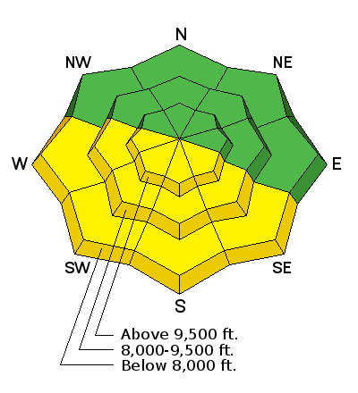
bottom line The avalanche danger is MODERATE this morning on west through southeast aspects that received the most sunshine yesterday. Very warm temperatures yesterday and the lack of a refreeze this morning will make loose wet snow avalanches possible, but cooler temperatures should decrease the danger of this problem throughout the day. North aspects that did not heat up as much yesterday have a LOW avalanche danger.
|
 |
special announcement The Utah Avalanche Center greatly values our longtime partnership with our world-class resorts and is blowing out the remaining donated lift tickets from Snowbird, Snowbasin, Sundance, and Nordic Valley with reduced prices. Every penny you spend benefits the Utah Avalanche Center. Check out our Garage Sale! Chock full of sweet backcountry gear - you can find the goods on our Facebook page here. |
 |
current conditions A few thin clouds were moving over the area this morning ahead of a weak storm. Temperatures yesterday reached the upper 40's F in most areas and only cooled to the mid 30's F this morning above 9000 feet. In a few places below 9000 feet in the Cottonwood Canyons, temperatures cooled to the mid 20's F. Winds increased and are blowing 15-20 mph gusting to 30 mph from the WSW. With thin cloud cover this morning and air temperatures that did not drop below freezing overnight in many locations, the snow may remain wet from yesterday's warm, sunny weather.
|
 |
recent activity There was no reported avalanche activity yesterday, but I suspect the very warm sunny weather caused at least a few loose, wet snow avalanches. |
| type | aspect/elevation | characteristics |
|---|

|
|
LIKELIHOOD
 LIKELY
UNLIKELY
SIZE
 LARGE
SMALL
TREND
 INCREASING DANGER
SAME
DECREASING DANGER
|
|
description
Air temperatures that did not drop below freezing and thin cloud cover are the red flags this morning. Clouds act as a blanket and prevent the snowpack from cooling due to longwave raditional heat loss to the sky. Fortunately the snowpack experienced a gradual warm up this week, and I don't expect any major wet snow avalanche activity this morning. Air temperatures will cool, and the danger of loose, wet snow avalanches should decrease today. Even though today should be much cooler than yesterday, glide avalanches are a remote possibility in the steep rocky slab terrain of Stairs Gulch, Broads Fork and Mill B South of Big Cottonwood Canyon. These types of slides happen at random times, and it's best to simply avoid the runout zones. See pictures HERE of a glide avalanche that released early this week in Broad's Fork.
|
 |
weather Today temperatures will cool and slowly drop below freezing. Late morning winds will briefly increase from the W and blow up to 40 mph; otherwise, they should blow 10-20 mph as they slowly shift to the NW by this evening. Some snow will fall today, but we'll be lucky if an inch or two accumulates. Tonight and Sunday will be dry followed by another very weak storm Monday that may only bring a trace of snow as well. |
| general announcements Remember your information can save lives. If you see anything we should know about, please help us out by submitting snow and avalanche conditions. You can also call us at 801-524-5304, email by clicking HERE, or include #utavy in your tweet or Instagram. To get help in an emergency (to request a rescue) in the Wasatch, call 911. Be prepared to give your GPS coordinates or the run name. Dispatchers have a copy of the Wasatch Backcountry Ski map. Backcountry Emergencies. It outlines your step-by-step method in the event of a winter backcountry incident. If you trigger an avalanche in the backcountry, but no one is hurt and you do not need assistance, please notify the nearest ski area dispatch to avoid a needless response by rescue teams. Thanks.
EMAIL ADVISORY If you would like to get the daily advisory by email you will need to subscribe here. DAWN PATROL Hotline updated daily by 5-530am - 888-999-4019 option 8. TWITTER Updates for your mobile phone - DETAILS UDOT canyon closures: LINK TO UDOT, or on Twitter, follow @UDOTavy, @CanyonAlerts or @AltaCentral Utah Avalanche Center mobile app - Get your advisory on your iPhone along with great navigation and rescue tools. Powderbird Helicopter Skiing - Blog/itinerary for the day Lost or Found something in the backcountry? - http://nolofo.com/ To those skinning uphill at resorts: it is critical to know the resort policy on uphill travel. You can see the uphill travel policy for each resort here. Benefit the Utah Avalanche Center when you shop from Backcountry.com or REI: Click this link for Backcountry.com or this link to REI, shop, and they will donate a percent of your purchase price to the UAC. Both offer free shipping (with some conditions) so this costs you nothing! Benefit the Utah Avalanche Center when you buy or sell on ebay - set the Utah Avalanche Center as a favorite non-profit in your ebay account here and click on ebay gives when you buy or sell. You can choose to have your seller fees donated to the UAC, which doesn't cost you a penny.
|


 This information does not apply to developed ski areas or highways where avalanche control is normally done. This advisory is from the U.S.D.A. Forest Service, which is solely responsible for its content. This advisory describes general avalanche conditions and local variations always exist.