| Please join us at the 23rd annual Black Diamond Fall Fundraiser Party Thursday Sept 15. Tickets are on sale now here, at the Black Diamond store & at REI. Special bonus raffle for online ticket purchasers! |
| Please join us at the 23rd annual Black Diamond Fall Fundraiser Party Thursday Sept 15. Tickets are on sale now here, at the Black Diamond store & at REI. Special bonus raffle for online ticket purchasers! |
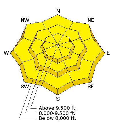
| Advisory: Salt Lake Area Mountains | Issued by Greg Gagne for Friday - February 19, 2016 - 5:03am |
|---|

|
bottom line A MODERATE hazard for today with the primary concern being fresh wind drifts at mid and upper elevations. Although I am not expecting winds to be all that strong during the day today, any increase in winds may create fresh wind slabs, particularly at the upper elevations. This will likely bump the hazard up a notch. Also be sure to watch for signs of wet loose avalanche activity as the day warms at all lower elevation aspects. For those who simply don't want to mess in avalanche terrain today, stay on slopes less steep than 35 degrees and you will find safe, superb riding conditions.
|
 |
special announcement Companion Rescue Fundamentals Course at Brighton, Friday, February 19th. Click for more info. HERE
|
 |
current conditions Well, that was exciting. Very strong pre-frontal winds following by a classic cold front bringing graupel and thunder snow. Following the front, a short period of intense snowfall and continued sustained winds from westerly directions. Snowfall largely shut down by late afternoon, and the winds began to mercifully decline. Temperatures have now cooled to upper teens and low twenties, and winds have also diminished to mid teens with gusts in the 25-30 mph range and are out of a westerly direction. Snowfall totals are about 5-8" in the upper reaches of the Cottonwoods and along the Park City ridgeline, but with such strong winds, accurately measuring snowfall totals is, ah, challenging. Riding and travel conditions should be excellent today with dense new snow on top of smooth, supportable slopes. |
 |
recent activity There were very few observations reported from yesterday. Prior to the frontal passage, there wasn't enough loose snow to move around to create widespread drifting. However, once the front passed and snow filled in behind, the wind went to work. However, only isolated pockets of wind slabs were reported. These were mostly shallow (3-6"), but a few isolated pockets at upper elevations were reported to be up to 18". Avalanche reduction work using explosives at Cottonwood resorts released a few larger slides in upper elevation wind-loaded terrain. A few observations noted the graupel providing a weak layer underneath fresh wind slabs. Perhaps the most significant weather highlight was the number of downed trees reported, even at lower elevations. [Mark White Photo]
|
| type | aspect/elevation | characteristics |
|---|

|
|
LIKELIHOOD
 LIKELY
UNLIKELY
SIZE
 LARGE
SMALL
TREND
 INCREASING DANGER
SAME
DECREASING DANGER
|
|
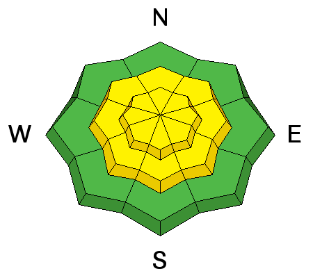
description
The wind prior to the front was clearly the headline story, with a few observers noting a large number of downed trees from the strong winds. However, wind needs loose snow to create an avalanche problem, and prior to the front, there just wasn't enough loose snow available for transport. Although the winds remained strong following the frontal passage, the relatively meager snow totals of 5-8" wasn't enough to create widespread wind drifting and loading. Today we are going with a Moderate hazard at mid and upper elevations with fresh wind drifts the primary concern. This is not the "Moderate is the new low", but "old school Moderate" where human triggered avalanches are possible. You can find wind drifted snow on a variety of aspects at mid and upper elevations, although they are likely to be more common on slopes with an Easterly component. As graupel often pools below cliff bands and steeper slopes, these wind slabs may be especially sensitive at mid elevations where they may be sitting on a graupel layer. Ski cuts and cornice drops are effective at mitigating a fresh wind slabs, however I also found the old snow surface to be either hard or slick on many aspects, so even if you did trigger a small wind slab, consider the consequences if you are unable to get off of the bed surface where you may dragged into trees or over rocks. Finally, two avalanches from this past Monday got my interest: they were both along the Park City ridgeline, and involved "repeater" slopes that had a thin pre-existing snowpack. I looked at the slide in No Name on Tuesday, where the President's Day 6" storm slab overloaded the weak snow underneath; only requiring a ski cut to trigger the slide. This tells me that thin snowpack areas continue to be susceptible to continued avalanching, and the strong winds and snowfall from Thursday may be enough of a load to again offset the balance on these slopes.
|
| type | aspect/elevation | characteristics |
|---|

|
|
LIKELIHOOD
 LIKELY
UNLIKELY
SIZE
 LARGE
SMALL
TREND
 INCREASING DANGER
SAME
DECREASING DANGER
|
|
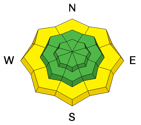
description
I think the partly cloudy skies and winds should keep the snow surface cool today, but if the sun does come out for any extended period, solar aspects may become active with heating from the sun. Additionally, north facing lower elevations may quickly become damp as the day warms. Soggy wet snow or rollerballs are a sure sign the snow surface is getting too warm. |
 |
weather Today should be partly cloudy with temperatures rising into the mid 30's F at 9000' and right around freezing at 10000'. Winds will be moderate and from the southwest with gusts up to 25 mph along 9000' ridges. At 11000' you can expect winds to be in the mid 20s mph, with gusts perhaps as high as 45 mph. A weak disturbance overnight today and then possibly later in the weekend, but most of the energy seems to be going to the north of us. In the long range there may be a glimmer of hope about a week away. |
| general announcements Remember your information can save lives. If you see anything we should know about, please participate in the creation of our own community avalanche advisory by submitting snow and avalanche conditions. You can also call us at 801-524-5304, email by clicking HERE, or include #utavy in your tweet or Instagram. To get help in an emergency (to launch a rescue) in the Wasatch, call 911. Be prepared to give your GPS coordinates or the run name. Dispatchers have a copy of the Wasatch Backcountry Ski map. Backcountry Emergencies. It outlines your step-by-step method in the event of a winter backcountry incident. If you trigger an avalanche in the backcountry, but no one is hurt and you do not need assistance, please notify the nearest ski area dispatch to avoid a needless response by rescue teams. Thanks. Salt Lake and Park City – Alta Central (801-742-2033), Canyons Resort/PCMR Dispatch (435)615-1911 Snowbasin Resort Dispatch (801-620-1017), Powder Mountain Dispatch (801-745-3772 x 123). Sundance Dispatch (801-223-4150) EMAIL ADVISORY If you would like to get the daily advisory by email you will need to subscribe here. DAWN PATROL Hotline updated daily by 5-530am - 888-999-4019 option 8. Twitter Updates for your mobile phone - DETAILS UDOT canyon closures: LINK TO UDOT, or on Twitter, follow @UDOTavy, @CanyonAlerts or @AltaCentral Utah Avalanche Center mobile app - Get your advisory on your iPhone along with great navigation and rescue tools. Powderbird Helicopter Skiing - Blog/itinerary for the day Lost or Found something in the backcountry? - http://nolofo.com/ To those skinning uphill at resorts: it is your responsibility to know the resort policy on uphill travel. You can see the uphill travel policy for each resort here. IMPORTANT: Before skinning or hiking at a resort under new snow conditions, check in with Ski Patrol. Resorts can restrict or cut off access if incompatible with control and grooming operations. Benefit the Utah Avalanche Center when you shop from Backcountry.com or REI: Click this link for Backcountry.com or this link to REI, shop, and they will donate a percent of your purchase price to the UAC. Both offer free shipping (with some conditions) so this costs you nothing! Benefit the Utah Avalanche Center when you buy or sell on ebay - set the Utah Avalanche Center as a favorite non-profit in your ebay account here and click on ebay gives when you buy or sell. You can choose to have your seller fees donated to the UAC, which doesn't cost you a penny. This information does not apply to developed ski areas or highways where avalanche control is normally done. This advisory is from the U.S.D.A. Forest Service, which is solely responsible for its content. This advisory describes general avalanche conditions and local variations always exist. |


