| Please join us at the 23rd annual Black Diamond Fall Fundraiser Party Thursday Sept 15. Tickets are on sale now here, at the Black Diamond store & at REI. Special bonus raffle for online ticket purchasers! |
| Please join us at the 23rd annual Black Diamond Fall Fundraiser Party Thursday Sept 15. Tickets are on sale now here, at the Black Diamond store & at REI. Special bonus raffle for online ticket purchasers! |
| Advisory: Salt Lake Area Mountains | Issued by Evelyn Lees for Monday - February 15, 2016 - 6:56am |
|---|

|
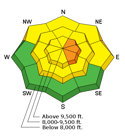
bottom line The avalanche danger of triggering a wind drift on a steep slope is CONSIDERABLE today at the upper elevations, and MODERATE at the mid elevations, particularly in Little Cottonwood, which received the most snow. Out of the wind drifted terrain, there is a MODERATE avalanche danger for triggering sluffs on steep slopes, storm slabs where the graupel has pooled beneath cliff bands and wet loose sluffs at the lower elevations.
Best turning and riding will be on lower angled, more wind sheltered slopes where the dense snow has mostly filled in the old tracks.
|
 |
special announcement Tuesday, February 16th - Companion Rescue at Weller Recreation from 6:30-9pm. For more info HERE. WBSKIING: Steve Achelis has released his updated Wasatch Backcountry Skiing desktop webpage - wbskiing.com Check out our Garage Sale! Chock full of sweet backcountry gear - you can find the goods on our Facebook page here |
 |
current conditions While it’s soggy and rainy down low, the upper elevations got a nice shot of dense snow. The Ogden area mountains received up to 6” (10% density) and upper Little Cottonwood up to 8” (15 to 20% density). Big Cottonwood, the Provo area mountains and PC side received 2 to 5” of similarly dense snow. The rain/snow line is around 7,000’ this morning. The westerly winds are still cranking, averaging around 40 mph along the highest ridge lines and 10 to 15 mph in the mid elevation terrain.
This dense snow is the just the ticket to fill in old tracks and cover the hard icy slopes. |
 |
recent activity Only reports of avalanches were from the Ogden area mountains, which received the most snow yesterday. There, ski cuts released wind slabs 1 to 2 feet deep, with activity at both upper and mid elevations, and there were also some long running sluffs. |
| type | aspect/elevation | characteristics |
|---|

|
|
LIKELIHOOD
 LIKELY
UNLIKELY
SIZE
 LARGE
SMALL
TREND
 INCREASING DANGER
SAME
DECREASING DANGER
|
|
description
The wind drifts will be sensitive today, especially along the higher ridge lines in the areas that received the most snow. Slopes facing the east ½ of compass will have the most widespread and deepest drifts, but watch for cross loading on other aspects and around features such as sub ridges, break overs and gully walls, at both mid and upper elevations and in open bowls. Avoid any steep, wind-drifted slope - the most likely place to trigger a slide today. |
| type | aspect/elevation | characteristics |
|---|

|
|
LIKELIHOOD
 LIKELY
UNLIKELY
SIZE
LARGE
SMALL
TREND
INCREASING DANGER
SAME
DECREASING DANGER
|
|
description
Out of the wind-drifted terrain, the avalanche problems include loose snow sluffs and soft slabs, mostly in areas that received the higher snow amounts.
Loose snow sluffs could be triggered on steep slopes of any aspect, and may run further than expected on the slick crusts or dry sugary snow.
Graupel pooling - the ball-like pellets of snow will run down and pile up below cliff bands and at the bottoms of steep gullies and chutes, forming deeper slabs that could be triggered today |
| type | aspect/elevation | characteristics |
|---|

|
|
LIKELIHOOD
LIKELY
UNLIKELY
SIZE
 LARGE
SMALL
TREND
INCREASING DANGER
SAME
DECREASING DANGER
|
|
description
Many of the lowest elevation drainages and slopes remained in the cold part of the temperature inversion last week and have now finally “mixed out”. Rain falling on the faceted snow may trigger small wet loose sluffs on steep slopes like creek beds and road banks. Keep an eye on the rain/snow line today, and avoid soggy wet snow on even small steep slopes at the lower and mid elevations |
 |
weather Riming and light snowfall will continue under a warm, moist northwest flow through mid morning, with additional inch or two of snow possible. The westerly winds will blast the higher ridge lines all day, averaging to 40 mph, with gusts to 60. At the mid elevations, expect 10 to 15 mph averages. Temperatures will warm into the upper 30s at 8,000’ today and into the upper 20s at 10,000’. The rain/snow line will be around 7,500 to 8,000’.
A warm, dry southwest flow will develop Tuesday into Wednesday, with 10,000’ temperatures soaring into the upper 30s by Wednesday. Winds become strong Wednesday night into Thursday ahead of a cold front, which will cross the Wasatch midday Thursday with a burst of snow. |
general announcements
|


