| Please join us at the 23rd annual Black Diamond Fall Fundraiser Party Thursday Sept 15. Tickets are on sale now here, at the Black Diamond store & at REI. Special bonus raffle for online ticket purchasers! |
| Please join us at the 23rd annual Black Diamond Fall Fundraiser Party Thursday Sept 15. Tickets are on sale now here, at the Black Diamond store & at REI. Special bonus raffle for online ticket purchasers! |
| Advisory: Salt Lake Area Mountains | Issued by Mark Staples for Thursday - February 11, 2016 - 6:16am |
|---|

|
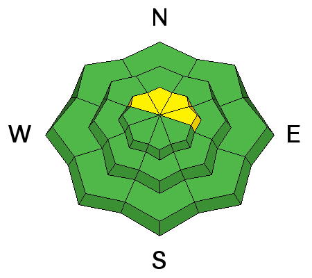
bottom line The avalanche danger is mostly LOW this morning. A MODERATE danger remains at high elevations due to the chance of a deep slab avalanche. Additionally, the danger will rise to MODERATE on south aspects due to a loose wet snow avalanche problem as things warm up.
|
 |
special announcement TODAY, February 11th, the Utah Adventure Journal speaker series features Todd Offenbacher More info HERE. |
 |
current conditions This morning temperatures are generally 5 degrees cooler than yesterday morning which is a good thing.
Winds are blowing 10 mph gusting to 15 mph mostly from the west. Snow on shaded aspects has remained dry. Unfortunately it has also become loose and faceted with some surface hoar (aka - frozen dew) at lower elevations. Why has shaded snow stayed cold and become weak and faceted? See the below graph showing air temperature and snow surface temperature from Bunnell's Ridge. Notice that snow surface temperature has remained below freezing. Also notice that the snow surface has experienced wide fluxuations in temperature. Unfortunately snow temperature about a foot deep hardly varies, thus we get a big temperature difference over a short distance otherwise know as a big temperature gradient which creates faceted snow.
Photo of surface hoar which is frozen dew (M. White) from Little Cottonwood Canyon.
|
 |
recent activity There was minimal wet loose avalanche activity yesterday, and most occurred earlier this week. Additionally there were some wind slabs that released early this week but none yesterday. |
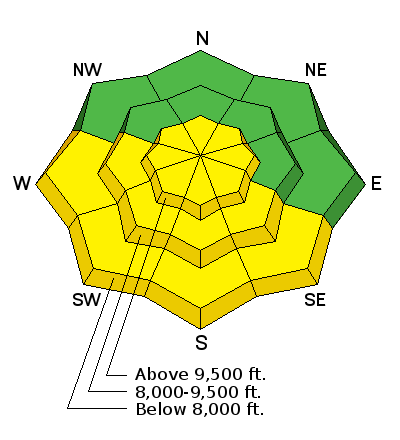
| type | aspect/elevation | characteristics |
|---|

|
|
LIKELIHOOD
 LIKELY
UNLIKELY
SIZE
 LARGE
SMALL
TREND
 INCREASING DANGER
SAME
DECREASING DANGER
|
|
description
North aspects and shaded slopes still have dry snow (see snow surface temperature in the above graph from a shaded slope). South aspects mostly got a good refreeze last night. Watch for signs of instablity like small point releases near rocks or pinwheels and rollerballs of snow tumbling downhill to let you know that the wet snow avalanche danger is rising. Here's a great video from Bruce who was looking at southerly facing terrain on Tuesday: Bruce checking southerly slopes for wet activity |
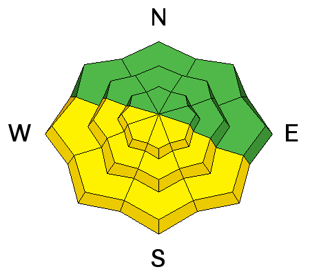
| type | aspect/elevation | characteristics |
|---|

|
|
LIKELIHOOD
 LIKELY
UNLIKELY
SIZE
 LARGE
SMALL
TREND
 INCREASING DANGER
SAME
DECREASING DANGER
|
|
description
The odds of Triggering a deep slab avalanche on facets near the ground are pretty low. Avalanche forecasters around the country have a hard time agreeing if we can have a deep slab avalanche problem and have a low danger. The problem is that the consequences are severe, and this type of avalanche problem tends to linger for a long time and surprise us as soon as we let our guard down. The most suspect areas are places with a shallower overall snowpack (3-4 feet deep) and slopes that have already avalanched 1 or 2 times this season. |
 |
weather Today will be similar to yesterday with sunny skies and warm temperatures. High temperatures should reach the mid 40s F again. Westerly winds will blow 10-20 mph. A few weak disturbances may move over the area this weekend and bring a chance for a few inches of snow. |
general announcements
|