| Please join us at the 23rd annual Black Diamond Fall Fundraiser Party Thursday Sept 15. Tickets are on sale now here, at the Black Diamond store & at REI. Special bonus raffle for online ticket purchasers! |
| Please join us at the 23rd annual Black Diamond Fall Fundraiser Party Thursday Sept 15. Tickets are on sale now here, at the Black Diamond store & at REI. Special bonus raffle for online ticket purchasers! |
| Advisory: Salt Lake Area Mountains | Issued by Drew Hardesty for Saturday - February 6, 2016 - 6:00am |
|---|

|
bottom line We have an overall MODERATE avalanche danger in the backcountry. Watch for new and developing wind drifts along the high elevations. The likelihood of triggering a deep slab avalanche is diminishing, but the consequences remain severe. Be mindful of how the sun and cloud cover affects the wet avalanche activity today.
|
 |
special announcement Tuesday February 9th - Fireside Chat at 7 p.m. at Black Diamond with UAC Forecaster Brett Kobernik who will discuss current conditions and discuss a near miss he had on Sunday when he was caught in an avalanche. For more info click HERE. Wednesday February 10th - Avalanche Clinic for Ice Climbers at 6 p.m. at Sandy Momentum climbing gym. For more info click HERE. |
 |
current conditions Skies are clear. With the building ridge of high pressure, temperatures are inverted and the northwest winds are picking up. Temps are in the low 20s at 10,000', the single digits in the basins and at many trailheads. The northwesterlies picked up overnight and are now blowing 15mph with gusts to 20/25. Along the 11,000' ridgelines, winds are blowing 35mph with gusts to 40. Clouds played cat and mouse with the sun yesterday, but enough sun kissed the southerlies and you'll find breakeable crust in that terrain this morning. Otherwise, riding conditions are excellent. |
 |
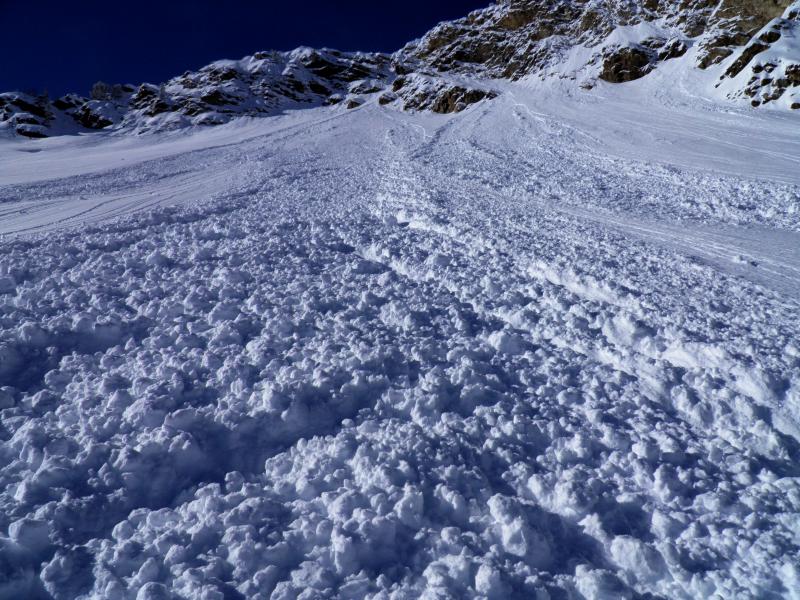
recent activity Nice to have a quiet day in this department. Small, shallow, loose dry and loose wet sluffs accompanied a few isolated shallow wind slabs to round out yesterday's activity. (pic - White)
|
| type | aspect/elevation | characteristics |
|---|

|

|
LIKELIHOOD
 LIKELY
UNLIKELY
SIZE
 LARGE
SMALL
TREND
 INCREASING DANGER
SAME
DECREASING DANGER
|
|
description
Watch for wind slab development today, particularly along the highest ridgelines. These may be particularly sensitive on the steep south to east facing terrain. |
| type | aspect/elevation | characteristics |
|---|

|

|
LIKELIHOOD
 LIKELY
UNLIKELY
SIZE
 LARGE
SMALL
TREND
INCREASING DANGER
SAME
DECREASING DANGER
|
|
description
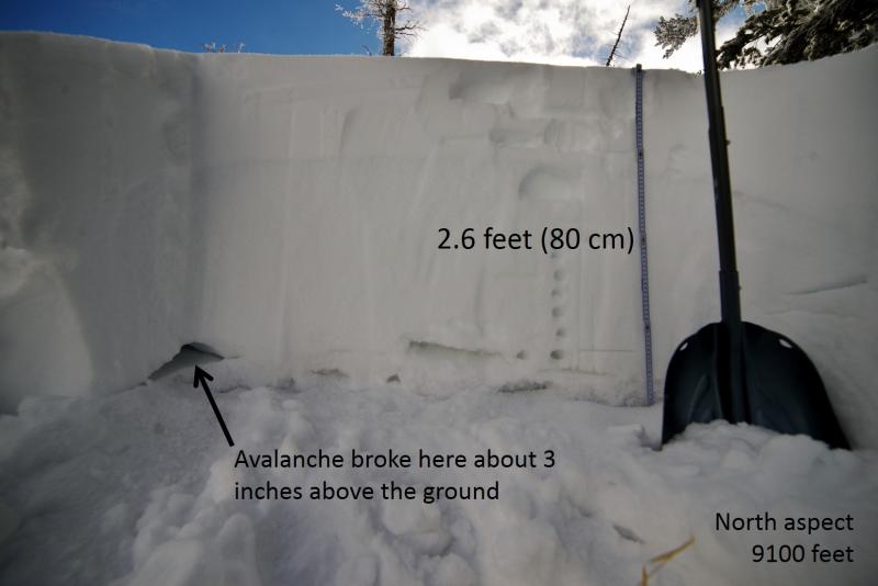
Low probability, high consequence. The last human triggered slide was in No Name on Tuesday. The repeaters are a minefield out there as some have detonated, some have been found inert. These are more prominent on northwest to north to easterly facing slopes above 9000' and tend to become more stressed with significant weather events. Trigger points often include thin, rocky areas. Remember that tracks on the slope are meaningless. Photos of the Point Peak and No Name photos below. (Staples, White)
Hot Tip! - we don't like to cry wolf and we know that many of you will be getting after it over the weekend. Set yourself up for success by considering what will happen if you happen to find the trigger-point for one of these. Will you be strained through the trees? Deeply buried in a steep-walled gulley? Carried over a cliff-band? Be smart - carry and know how to use your rescue gear, travel with good partners with good communication skills, consider an avalanche airbag. Most importantly, don't get caught in a slide...but if you do - consider what terrain you'll be carried into below. |
| type | aspect/elevation | characteristics |
|---|

|
|
LIKELIHOOD
LIKELY
UNLIKELY
SIZE
 LARGE
SMALL
TREND
 INCREASING DANGER
SAME
DECREASING DANGER
|
|
description
We'll only see some mid and high level clouds, but these will have some effect on the radiation balance at the snow surface, perhaps even on some of the lower elevation northerly slopes. Plus, the winds may help to cool the snow surface in the exposed terrain. Bottom line, I don't know. You'll know, however. Any dampening of the snow surface will be readily apparent with any sun and greenhousing...and if this is the case, choose terrain accordingly. |
 |
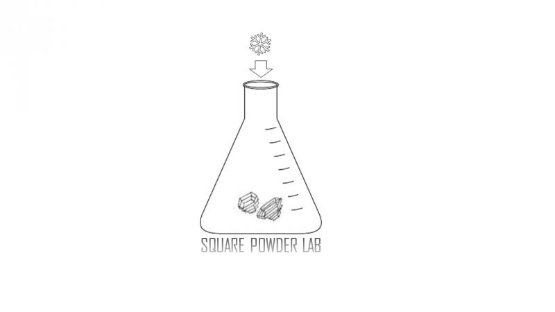
weather We'll have at times clear skies and mid and upper level cloud cover from a weak disturbance moving through out of the northwest. Winds should remain gusty out of the northwest. Temperatures will be in the mid 20s at 10,000', the mid-30s at 8000'. Looks like high pressure builds over the next week with significant warming expected by Monday into Tuesday. Tuesday's 10,000' temps soar to 40°F. In the meantime, the low density powder on the snow surface may start to facet and become weak over the next several days. The forecasters at Hatcher Pass call it "square powder". Image: Jed Workman from HPAC.
|
| general announcements Remember your information can save lives. If you see anything we should know about, please participate in the creation of our own community avalanche advisory by submitting snow and avalanche conditions. You can also call us at 801-524-5304, email by clicking HERE, or include #utavy in your tweet or Instagram. To get help in an emergency (to launch a rescue) in the Wasatch, call 911. Be prepared to give your GPS coordinates or the run name. Dispatchers have a copy of the Wasatch Backcountry Ski map. Backcountry Emergencies. It outlines your step-by-step method in the event of a winter backcountry incident. If you trigger an avalanche in the backcountry, but no one is hurt and you do not need assistance, please notify the nearest ski area dispatch to avoid a needless response by rescue teams. Thanks. Salt Lake and Park City – Alta Central (801-742-2033), Canyons Resort/PCMR Dispatch (435)615-1911 Snowbasin Resort Dispatch (801-620-1017), Powder Mountain Dispatch (801-745-3772 x 123). Sundance Dispatch (801-223-4150) EMAIL ADVISORY If you would like to get the daily advisory by email you will need to subscribe here. DAWN PATROL Hotline updated daily by 5-530am - 888-999-4019 option 8. Twitter Updates for your mobile phone - DETAILS UDOT canyon closures: LINK TO UDOT, or on Twitter, follow @UDOTavy, @CanyonAlerts or @AltaCentral Utah Avalanche Center mobile app - Get your advisory on your iPhone along with great navigation and rescue tools. Powderbird Helicopter Skiing - Blog/itinerary for the day Lost or Found something in the backcountry? - http://nolofo.com/ To those skinning uphill at resorts: it is your responsibility to know the resort policy on uphill travel. You can see the uphill travel policy for each resort here. IMPORTANT: Before skinning or hiking at a resort under new snow conditions, check in with Ski Patrol. Resorts can restrict or cut off access if incompatible with control and grooming operations. Benefit the Utah Avalanche Center when you shop from Backcountry.com or REI: Click this link for Backcountry.com or this link to REI, shop, and they will donate a percent of your purchase price to the UAC. Both offer free shipping (with some conditions) so this costs you nothing! Benefit the Utah Avalanche Center when you buy or sell on ebay - set the Utah Avalanche Center as a favorite non-profit in your ebay account here and click on ebay gives when you buy or sell. You can choose to have your seller fees donated to the UAC, which doesn't cost you a penny. This information does not apply to developed ski areas or highways where avalanche control is normally done. This advisory is from the U.S.D.A. Forest Service, which is solely responsible for its content. This advisory describes general avalanche conditions and local variations always exist. |