| Please join us at the 23rd annual Black Diamond Fall Fundraiser Party Thursday Sept 15. Tickets are on sale now here, at the Black Diamond store & at REI. Special bonus raffle for online ticket purchasers! |
| Please join us at the 23rd annual Black Diamond Fall Fundraiser Party Thursday Sept 15. Tickets are on sale now here, at the Black Diamond store & at REI. Special bonus raffle for online ticket purchasers! |
| Advisory: Salt Lake Area Mountains | Issued by Evelyn Lees for Wednesday - January 27, 2016 - 6:56am |
|---|

|
bottom line The Avalanche Danger is CONSIDERABLE on all upper elevation slopes approaching 35 degrees and steeper. While deeper slides are most likely on steep, northwest through easterly facing slopes, they can be triggered in isolated places on southeast through westerly facing slopes. Smaller wind drifts and sluffs can still be triggered at the upper elevations.
Avoid steep, sunny slopes facing east through south through west where the avalanche danger could rise as high as CONSIDERABLE once the snow dampens from sun and daytime heating.
Safer terrain includes lower angle, wind sheltered slopes.
|
 |
special announcement There are still spaces in the Women’s Backcountry 101 avalanche class at Brighton (Feb 4/6) and the Women’s Snowbasin Avalanche Awareness class Feb (18/20). For more info on those classes and other education offerings through out the state, check out our Education Page.
Check out this January Avalanche Accident Blog from Spencer Logan, Colorado Avalanche Information Center.
Lose or find something in the backcountry? Go to nolofo.com to place a gear lost or found notice. |
 |
current conditions It’s a beautiful morning, with clear skies, light winds and warm temperatures. Most mountain locations are in the twenties, with teens in the valley bottoms where the cold air has pooled. The northwesterly winds are averaging in the 5 to 15 mph range. Many slopes are sun and wind crusted; the highest quality powder is on wind sheltered, northerly facing slopes. |
 |
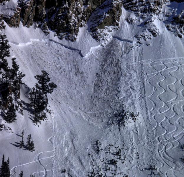
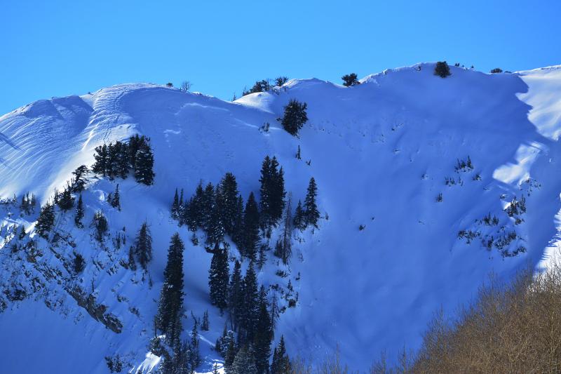
recent activity There were 3 human triggered avalanches yesterday breaking to the ground on depth hoar. Two, the Argenta headwall and Silver Fork headwall, were triggered by intentional cornice drops. The third, Holy Toledo, broke out on the 5th skier, who was carried and injured. These were on north to northwest facing slopes, and known or assumed to be repeaters. There was also a round of natural and human triggered wind slabs in Salt Lake and Ogden area mountains, with one person going for a ride in continuously steep 40+ degree terrain.
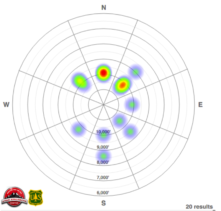
While our data base is incomplete, the heat map below shows the aspects and elevations of the avalanches we have recorded in Wasatch mountains this past week, showing almost all aspects have had significant avalanches.
|
| type | aspect/elevation | characteristics |
|---|

|
|
LIKELIHOOD
 LIKELY
UNLIKELY
SIZE
 LARGE
SMALL
TREND
 INCREASING DANGER
SAME
DECREASING DANGER
|
|
description
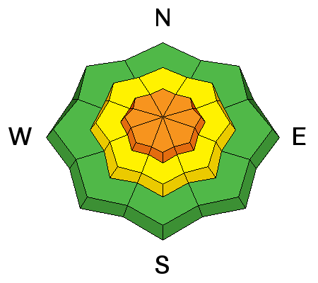
The largest, most dangerous avalanches today will be any slide breaking on facets – near the ground on NW through easterly facing slopes and midpack on the southerly through westerly facing slopes. Faceted weak layers can be found around the compass – on all aspects – at the upper elevations. However, slopes that have previously slid one or more times this year and refilled with snow are the most likely places to trigger a slide today, which are mostly on steep upper elevation northwest through easterly facing slopes. Left: Holy Toledo, Mark White Right: Argenta Head wall, Colby Stetson photo
|
| type | aspect/elevation | characteristics |
|---|

|
|
LIKELIHOOD
 LIKELY
UNLIKELY
SIZE
 LARGE
SMALL
TREND
 INCREASING DANGER
SAME
DECREASING DANGER
|
|
description
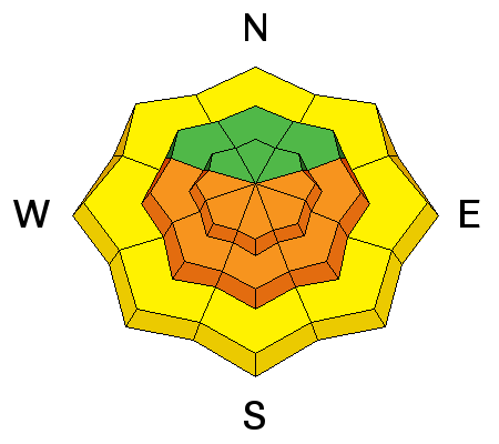
Abundant sunshine and another jump in temperatures today will increase wet avalanche activity. Cloud cover is the wild card - periods of high thin clouds could keep the sunny slopes cooler, yet allow the mid and low elevation northerly facing slopes to heat. (“greenhousing”) As the snow becomes damp, or you see roller balls and small sluffs, it’s time to get off steep sunny slopes. |
| type | aspect/elevation | characteristics |
|---|

|
|
LIKELIHOOD
LIKELY
UNLIKELY
SIZE
 LARGE
SMALL
TREND
 INCREASING DANGER
SAME
DECREASING DANGER
|
|
description
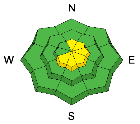
The wind slabs will be more stubborn today. Avoid these denser, cracky and even hard drifts on steep slopes. Terrain key here – a ride in even a small slide can have a bad outcome if you hit trees, go off a cliff or end in a gully terrain trap. Winds could increase today along the highest ridgelines, so reassess your travel if they start drifting snow where you are.
Gobbler wind slab, natural. Fred Staff photo
|
 |
weather Strong high pressure moving in will bring warming temperatures and light, northwesterly winds. 8,000’ highs will be near 40, 10,000’ highs near 30. Average winds speeds should remain below 15 mph, though speeds across the highest peaks could increase to 25 mph, with gusts to 40. |
general announcements
|