| Please join us at the 23rd annual Black Diamond Fall Fundraiser Party Thursday Sept 15. Tickets are on sale now here, at the Black Diamond store & at REI. Special bonus raffle for online ticket purchasers! |
| Please join us at the 23rd annual Black Diamond Fall Fundraiser Party Thursday Sept 15. Tickets are on sale now here, at the Black Diamond store & at REI. Special bonus raffle for online ticket purchasers! |
| Advisory: Salt Lake Area Mountains | Issued by Drew Hardesty for Monday - January 25, 2016 - 5:57am |
|---|


|
bottom line We have a Considerable danger in the backcountry right now. Human triggered sluffs and wind drifts are likely in steep terrain today. It is still possible to trigger avalanches 2-3' deep into older faceted snow on a variety of aspects. If we get more sun and heating that expected, the new snow may become more active in the steepest sun-kissed terrain. The snowpack is complicated right now. When I find that things start getting complicated, it's time to step back toward simplicity: slope angle and proper terrain analysis. Give yourself a good margin for error.
|
 |
special announcement Little Cottonwood Canyon has backcountry closures in effect on the north side of the road until roughly 8am this morning with a canyon shoot at 5:45 this morning. Remember that the White Pine trailhead is the best option in LCC when UDOT has closures in effect. There are still spaces in the Women’s Backcountry 101 avalanche class at Brighton (Feb 4/6) and the Women’s Snowbasin Avalanche Awareness class Feb (18/20). For more info on those classes and other education offerings through out the state, check out our Education Page. |
 |
current conditions Snow. The central Wasatch picked up another 4-6" overnight. 24 hour totals are up to a 1' of fresh, with storm totals since late Saturday up to nearly 2'. The Park City ridgeline picked up 3-5" overnight with storm totals of 12-16". Overnight densities are roughly 6-7%. Mountain temperatures are in the mid to upper teens at 8000', roughly 10°F at 10,000'. Don't let the light northerly winds this morning fool you - the northwesterlies blew 15-20mph at many locations for a few hours overnight with 11,000' hourly averages pushing into the mid to upper 40mph range with gusts into the 60s and 70s.
|
 |
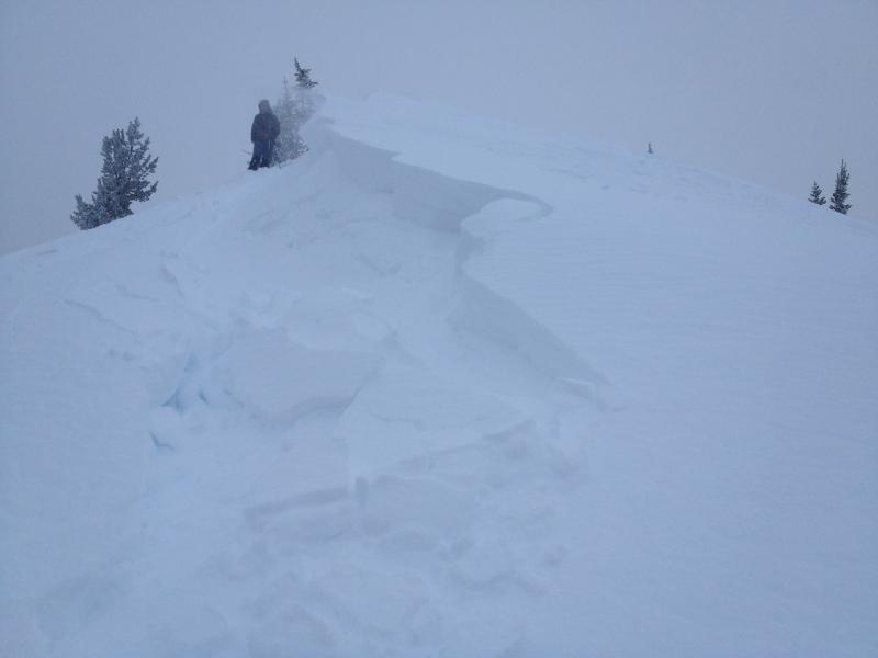
recent activity How recent is now? As I write this at 5am, longer running natural loose dry snow avalanches are moving on some of the steepest alpine terrain at the mid and upper elevations. It's a bit of a mirror image of yesterday morning. Thankfully, the natural activity quieted down yesterday as the new snow somewhat stabilized to the point where they then needed a human trigger. Increasing winds, however, stiffened up some of the new snow and fresh wind drifts moved with explosives and intentional ski cuts through the afternoon. (Photo: Wilson)
And another thing - the US is up to 14 fatalities for the season, with 9 avalanche related deaths in the last 9 days alone. Some of these incident have been with very experienced backcountry folks. Something else that comes to mind when looking at the most recent 4 incidents below: in each of them, more than one person was caught and carried in the slide. The take-home here is to assess the terrain and put only one person on the slope - or even runout zones - at a time. 2015-2016 Airbags? My email to a guy asking about the full burial with airbag on the Gobbler's incident from Thursday -
|
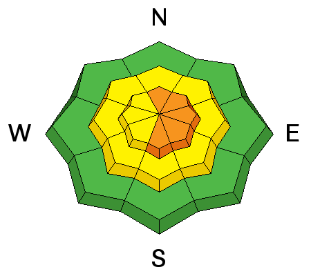
| type | aspect/elevation | characteristics |
|---|

|
|
LIKELIHOOD
 LIKELY
UNLIKELY
SIZE
 LARGE
SMALL
TREND
 INCREASING DANGER
SAME
DECREASING DANGER
|
|
description
It's sometimes called "sucker snow" for a reason. Last night's wind slabs are largely buried and hidden beneath the new 4-6" of fresh, but the drifts will still be sensitive to human weight. I suspect by now, these drifts may be up to 2' deep and can pack a punch. It may be that one could get some of the blower powder moving as a sluff only to have it prod the overnight whales into moving as well. Ski cuts and cornice drops should give good indication of localized stability... but remember that these aren't for the faint of heart and can be at times dangerous at best. Click on the 'i' for more info on Wind Slabs. |
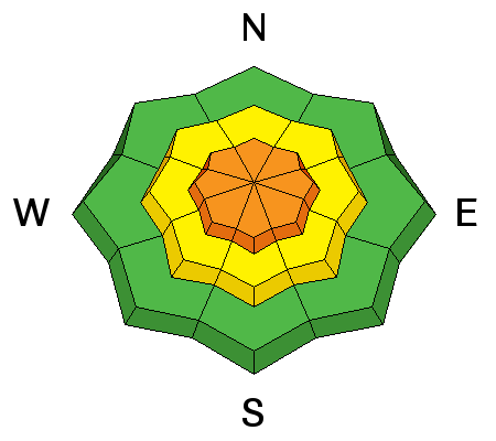
| type | aspect/elevation | characteristics |
|---|

|
|
LIKELIHOOD
LIKELY
UNLIKELY
SIZE
LARGE
SMALL
TREND
INCREASING DANGER
SAME
DECREASING DANGER
|
|
description
The surest sign of avalanche danger is - you guessed it - avalanches. If natural activity is occurring now, human triggered activity today will be likely in the same type of terrain. Sluffs typically take a steeper slope angle to get moving (approaching 40° in steepness) and can certainly pack a punch in steep sustained terrain. In terrain like this, it'll be key to stay on sub-ridges and spines, or move diagonally across the fall line to avoid being taken out by your own sluff. By nature, they don't propagate laterally with initiation but they can sure reach what long-time avalanche worker Dave Medara calls "hovercraft mode". You'll know it when you see it. Click on the 'i' for more info on Loose Dry Snow (sluffs aka point releases). |
| type | aspect/elevation | characteristics |
|---|

|

|
LIKELIHOOD
 LIKELY
UNLIKELY
SIZE
 LARGE
SMALL
TREND
 INCREASING DANGER
SAME
DECREASING DANGER
|
|
description
I gotta tell you - the snowpack is as complicated and complex as I've seen in a few years. Repeater avalanches. Persistent slab avalanches on southerly aspects. Persistent slabs down to 8500'. Doing the work and pulling out the shovel is key in assessing the snow structure - but how to get out into repeater terrain without putting oneself at risk? Rope? Click on the 'i' for more info on Persistent Slabs.
|
 |
weather We should be able to squeeze a few more instability flakes of snow out of the departing storm and transition toward mostly cloudy to partly cloudy skies. Temperatures should remain cold - we're looking at the low teens at 10,000', the low 20s at 8000'. Winds should remain light (10-15mph) from the north-northwest. Ridging will move in this afternoon through early Friday. Winds should remain generally light from the northwest over the next few days as 10,000' temps rise toward freezing by Wednesday. Models bring another series of storms through by late Friday. |
| general announcements Remember your information can save lives. If you see anything we should know about, please participate in the creation of our own community avalanche advisory by submitting snow and avalanche conditions. You can also call us at 801-524-5304, email by clicking HERE, or include #utavy in your tweet or Instagram. To get help in an emergency (to launch a rescue) in the Wasatch, call 911. Be prepared to give your GPS coordinates or the run name. Dispatchers have a copy of the Wasatch Backcountry Ski map. Backcountry Emergencies. It outlines your step-by-step method in the event of a winter backcountry incident. If you trigger an avalanche in the backcountry, but no one is hurt and you do not need assistance, please notify the nearest ski area dispatch to avoid a needless response by rescue teams. Thanks. Salt Lake and Park City – Alta Central (801-742-2033), Canyons Resort/PCMR Dispatch (435)615-1911 Snowbasin Resort Dispatch (801-620-1017), Powder Mountain Dispatch (801-745-3772 x 123). Sundance Dispatch (801-223-4150) EMAIL ADVISORY If you would like to get the daily advisory by email you will need to subscribe here. DAWN PATROL Hotline updated daily by 5-530am - 888-999-4019 option 8. Twitter Updates for your mobile phone - DETAILS UDOT canyon closures: LINK TO UDOT, or on Twitter, follow @UDOTavy, @CanyonAlerts or @AltaCentral Utah Avalanche Center mobile app - Get your advisory on your iPhone along with great navigation and rescue tools. Powderbird Helicopter Skiing - Blog/itinerary for the day Lost or Found something in the backcountry? - http://nolofo.com/ To those skinning uphill at resorts: it is your responsibility to know the resort policy on uphill travel. You can see the uphill travel policy for each resort here. IMPORTANT: Before skinning or hiking at a resort under new snow conditions, check in with Ski Patrol. Resorts can restrict or cut off access if incompatible with control and grooming operations. Benefit the Utah Avalanche Center when you shop from Backcountry.com or REI: Click this link for Backcountry.com or this link to REI, shop, and they will donate a percent of your purchase price to the UAC. Both offer free shipping (with some conditions) so this costs you nothing! Benefit the Utah Avalanche Center when you buy or sell on ebay - set the Utah Avalanche Center as a favorite non-profit in your ebay account here and click on ebay gives when you buy or sell. You can choose to have your seller fees donated to the UAC, which doesn't cost you a penny. This information does not apply to developed ski areas or highways where avalanche control is normally done. This advisory is from the U.S.D.A. Forest Service, which is solely responsible for its content. This advisory describes general avalanche conditions and local variations always exist. |