| Please join us at the 23rd annual Black Diamond Fall Fundraiser Party Thursday Sept 15. Tickets are on sale now here, at the Black Diamond store & at REI. Special bonus raffle for online ticket purchasers! |
| Please join us at the 23rd annual Black Diamond Fall Fundraiser Party Thursday Sept 15. Tickets are on sale now here, at the Black Diamond store & at REI. Special bonus raffle for online ticket purchasers! |
| Advisory: Salt Lake Area Mountains | Issued by Mark Staples for Friday - January 22, 2016 - 5:49am |
|---|

|
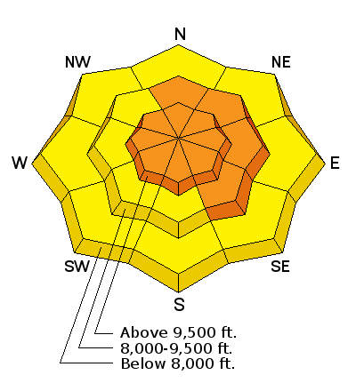
bottom line Today the avalanche danger is CONSIDERABLE at upper and mid elevations where dangerous avalanche conditions exist. Even though the Avalanche Warning from yesterday has expired, the danger has not gone away. Stability does not change overnight and widespread avalanche activity tells us that many slopes remain unstable waiting for a skier or rider to trigger them. Avalanches remain possible in avalanche terrain at low elevations where the danger is MODERATE.
|
 |
special announcement Avalanche Fatality on Gobblers Knob - 21 January 2016 We are very sad to report an avalanche fatality on the south face of Gobbler’s Knob yesterday. A pair of backcountry skiers was skiing the run in sections, when the slope broke out widely above them. One skier was caught and carried hundreds of feet down, and fully buried (in spite of having deployed an air bag). Found with a beacon search, he was transported to the hospital and declared dead. Our thoughts are with their family and friends. A preliminary report is HERE. Photo of the avalanche courtesy of KSL News.
|
 |
current conditions This morning with a temperature inversion in place, mountain temperatures are near freezing while places lower in the canyons have temperatures in the teens F. Winds shifted to the south early this morning and are blowing 10-15 mph gusting 25 mph. Many slopes have great riding conditions with only direct south aspects having a thin crust on them. |
 |
recent activity Keeping track of all the recent avalanche activity is overwhelming. You can view all the reported avalanches here. The take home point is that there has been a widespread avalanche cycle. Avalanches occurred all week, and the peak activity seems to have occurred midday Wednesday during a period of high snowfall intensity and strong WNW winds. Many slopes facing N, NE, and E avalanched just before Christmas and slid again this week (photo below). Slopes on other aspects produced avalanches including the fatal avalanche on the south face of Gobbler's Knob yesterday. Avalanche crowns of 3-6 feet were seen yesterday in the southerly facing, avalanche starting zones above Little Cottonwood Canyon. Photo of West Monitor Bowl along the Park City Ridgeline. These slides broke on facets at the ground. (photo: M. White)
|
| type | aspect/elevation | characteristics |
|---|

|
|
LIKELIHOOD
 LIKELY
UNLIKELY
SIZE
 LARGE
SMALL
TREND
 INCREASING DANGER
SAME
DECREASING DANGER
|
|
description
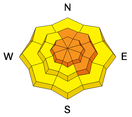
Persistent slab avalanches have several weak faceted layers on which they can fracture. For a good summary, read this blog post by Evelyn from Tuesday. Basically, there are facets near the ground, facets in the upper/middle portion of the snowpack that formed in the second week of Janary, and facets within the top foot of snow that formed early this week prior to Wednesday's snowfall. If this sounds confusing, it is. Focusing on avalanche activity provides clarity and recent avalanches are the primary clue of unstable conditions. Additionally, avalanches breaking over wide areas and avalanches being triggered remotely (aka - from some distance away from the slope), tells us that there are weak faceted layers in the snowpack producing these persistent slab avalanches. While natural avalanche activity has ended, human triggered avalanches remain likely.
|
| type | aspect/elevation | characteristics |
|---|

|
|
LIKELIHOOD
 LIKELY
UNLIKELY
SIZE
 LARGE
SMALL
TREND
INCREASING DANGER
SAME
DECREASING DANGER
|
|
description
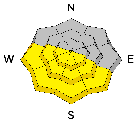
Air temperatures are near freezing this morning. Cloudy skies should limit rapid heating of the snowpack today from direct sunshine, but there will be some breaks in cloud cover. Its hard to say how much the snowpack will warm today. Sometimes cloud cover helps the snowpack warm by acting as a greenhouse. Since we don't know exactly what will happen, look for clues of potential wet avalanche activity. Usually you'll notice the snow surface becoming wet and small roller balls or point releases occurring. |
 |
weather Today southerly winds will blow 10-20 mph and bring mostly cloudy skies. The sun should appear at times. It's hard to say exactly how much temperatures should warm, but they should climb into the mid to upper 30s F above 9000 feet. Clouds should keep the warm-up from occurring too fast. The next storm should arrive Saturday evening. |
| general announcements Remember your information can save lives. If you see anything we should know about, please participate in the creation of our own community avalanche advisory by submitting snow and avalanche conditions. You can also call us at 801-524-5304, email by clicking HERE, or include #utavy in your tweet or Instagram. To get help in an emergency (to launch a rescue) in the Wasatch, call 911. Be prepared to give your GPS coordinates or the run name. Dispatchers have a copy of the Wasatch Backcountry Ski map. Backcountry Emergencies. It outlines your step-by-step method in the event of a winter backcountry incident. If you trigger an avalanche in the backcountry, but no one is hurt and you do not need assistance, please notify the nearest ski area dispatch to avoid a needless response by rescue teams. Thanks. Salt Lake and Park City – Alta Central (801-742-2033), Canyons Resort/PCMR Dispatch (435)615-1911 Snowbasin Resort Dispatch (801-620-1017), Powder Mountain Dispatch (801-745-3772 x 123). Sundance Dispatch (801-223-4150) EMAIL ADVISORY If you would like to get the daily advisory by email you will need to subscribe here. DAWN PATROL Hotline updated daily by 5-530am - 888-999-4019 option 8. Twitter Updates for your mobile phone - DETAILS UDOT canyon closures: LINK TO UDOT, or on Twitter, follow @UDOTavy, @CanyonAlerts or @AltaCentral Utah Avalanche Center mobile app - Get your advisory on your iPhone along with great navigation and rescue tools. Powderbird Helicopter Skiing - Blog/itinerary for the day Lost or Found something in the backcountry? - http://nolofo.com/ To those skinning uphill at resorts: it is your responsibility to know the resort policy on uphill travel. You can see the uphill travel policy for each resort here. IMPORTANT: Before skinning or hiking at a resort under new snow conditions, check in with Ski Patrol. Resorts can restrict or cut off access if incompatible with control and grooming operations. Benefit the Utah Avalanche Center when you shop from Backcountry.com or REI: Click this link for Backcountry.com or this link to REI, shop, and they will donate a percent of your purchase price to the UAC. Both offer free shipping (with some conditions) so this costs you nothing! Benefit the Utah Avalanche Center when you buy or sell on ebay - set the Utah Avalanche Center as a favorite non-profit in your ebay account here and click on ebay gives when you buy or sell. You can choose to have your seller fees donated to the UAC, which doesn't cost you a penny. This information does not apply to developed ski areas or highways where avalanche control is normally done. This advisory is from the U.S.D.A. Forest Service, which is solely responsible for its content. This advisory describes general avalanche conditions and local variations always exist. |


