| Please join us at the 23rd annual Black Diamond Fall Fundraiser Party Thursday Sept 15. Tickets are on sale now here, at the Black Diamond store & at REI. Special bonus raffle for online ticket purchasers! |
| Please join us at the 23rd annual Black Diamond Fall Fundraiser Party Thursday Sept 15. Tickets are on sale now here, at the Black Diamond store & at REI. Special bonus raffle for online ticket purchasers! |
| Advisory: Salt Lake Area Mountains | Issued by Evelyn Lees for Wednesday - January 20, 2016 - 6:47am |
|---|

|
bottom line The Avalanche Danger is HIGH today on upper elevation slopes, especially those that are steep and wind-drifted and slopes facing north through easterly. Avoid travel on and below these slopes, as natural avalanches are possible and avalanches can be triggered remotely. Travel in and below steep avalanche terrain is not recommended today. Wind sheltered, lower angle terrain offers a safer choice for very experienced travelers, as long as there are no steep slopes above.
|
 |
special announcement Thursday 6:00pm - Utah Adventure Journal Speaker Series continues at Snowbird's Wildflower Lounge with a special presentation from local snowboarder Cindi Lou Grant. "Ride in, Ride out" is the story of Cindi and her husband Zach's dream to have a home with the ultimate access to the mountains. If you can't make it to this talk check out the entire list of speakers here: https://goo.gl/ha05ir Our Dutch Auction continues: 180 cm La Sportiva Vapor Nano Skis (130/103/120mm -1200g). List price is $1,200. Here's the deal: We are offering these skis for sale to the first person that contacts us with a commitment to purchase. THE PRICE TODAY IS $850.00 AND WILL DROP $50 TOMORROW. The price will drop $50 per day until someone buys the skis. We'll toss in a free UAC t-shirt or trucker hat and handful of Clif Bar product. Contact: [email protected] |
 |
current conditions Storm one, a warm front, zipped through last night, dropping 2 to 4” of dense snow, with up to 6” of graupel-laden snow in the Provo area mountains. Winds blew very strongly from the southwest overnight for several hours. Storm two, a cold front, has just arrived, with lightning, snow, and more westerly winds ramping up again into the 15 to 25 mph range, with gusts to 40. The highest peaks are now averaging to 40 mph, with gusts to 70. Temperatures warmed overnight into the mid to upper 20s, but are now dropping. |
 |
recent activity There were at least 4 unintentionally triggered slides in the backcountry yesterday, and all were on north through east facing slopes that slid previously this year. 2 were along the Park City ridge line - MacDonald’s Draw and the gully north of Square Top; the other two were 2 Dogs in upper Days Fork and in Days Draw. An intentional ski cut released a 250’ wide slide on the Big Springs Nose in the Cascade mountains, and an avalanche worker in the Ogden area mountains had a very close call.
|
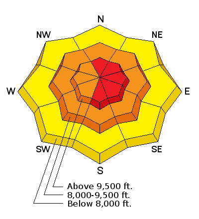
| type | aspect/elevation | characteristics |
|---|

|

|
LIKELIHOOD
 LIKELY
UNLIKELY
SIZE
 LARGE
SMALL
TREND
 INCREASING DANGER
SAME
DECREASING DANGER
|
|
description
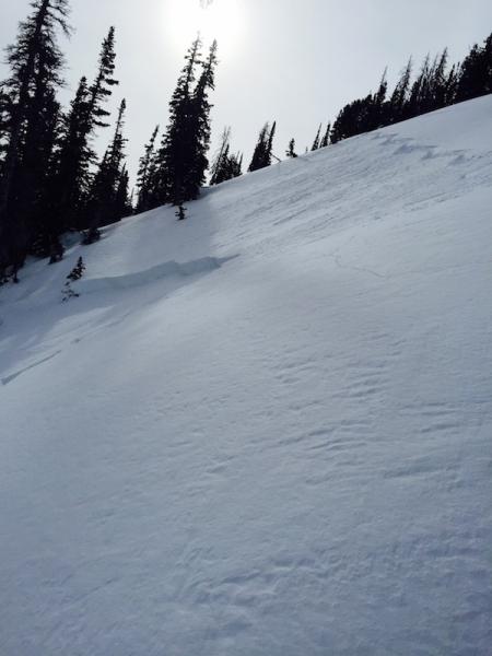
Strong winds are overloading our shaky snow pack, and once again the largest, most dangerous slides will be on slopes that have slide one or more times this year. Any steep slope facing northwest through easterly should be avoided today. On these slopes, the December slide cycle removed the slab, but not the weak layer. The snow pack is shallow and weak, and slides 2 to 3 feet deep can be triggered on slope, from a distance, from below, or may occur naturally today. Below: Big Springs slide, Cookler photo. On the right are some of my thoughts on the current snowpack from this blog.
|
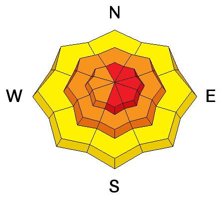
| type | aspect/elevation | characteristics |
|---|

|
|
LIKELIHOOD
 LIKELY
UNLIKELY
SIZE
 LARGE
SMALL
TREND
INCREASING DANGER
SAME
DECREASING DANGER
|
|
description
The new snow will be sensitive on steep slopes, especially during periods of heavy precipitation and on wind drifted slopes. Expect new snow slides on steep slopes of all aspects. Natural avalanches could occur today during periods of very heavy snowfall and on wind drifted slopes. It’s a convective storm, and the new snow amounts will be very uneven – one drainage could get 8”, another only 2”. Sluffs and new snow soft slab avalanches could occur on steep slopes of all aspects at the mid and lower elevations. |
 |
weather A cold, gusty storm is moving through the northern Utah mountains, and the strongest winds and heaviest snowfall rates are expected this morning. Lightning has occurred in the Ogden area mountains, and more is possible through around 9 am. Expect an additional 3 to 6” of snow, with rates of 2” an hour at times this morning. Winds are rapidly shifting to the west, and then to the northwest and will remain in the 15 to 20 mph range for much of the day, with the high ridge lines averaging 30 to 40 mph, with gusts to 60. Snow showers this afternoon into early evening could add a few more inches to areas favored by northwest flow. 10,000’ temperatures will drop to near 10 degrees. There will be a welcome break from the storms Thursday and Friday, with the next storm Saturday night. |
| general announcements Remember your information can save lives. If you see anything we should know about, please participate in the creation of our own community avalanche advisory by submitting snow and avalanche conditions. You can also call us at 801-524-5304, email by clicking HERE, or include #utavy in your tweet or Instagram. To get help in an emergency (to launch a rescue) in the Wasatch, call 911. Be prepared to give your GPS coordinates or the run name. Dispatchers have a copy of the Wasatch Backcountry Ski map. Backcountry Emergencies. It outlines your step-by-step method in the event of a winter backcountry incident. If you trigger an avalanche in the backcountry, but no one is hurt and you do not need assistance, please notify the nearest ski area dispatch to avoid a needless response by rescue teams. Thanks. Salt Lake and Park City – Alta Central (801-742-2033), Canyons Resort/PCMR Dispatch (435)615-1911 Snowbasin Resort Dispatch (801-620-1017), Powder Mountain Dispatch (801-745-3772 x 123). Sundance Dispatch (801-223-4150) EMAIL ADVISORY If you would like to get the daily advisory by email you will need to subscribe here. DAWN PATROL Hotline updated daily by 5-530am - 888-999-4019 option 8. Twitter Updates for your mobile phone - DETAILS UDOT canyon closures: LINK TO UDOT, or on Twitter, follow @UDOTavy, @CanyonAlerts or @AltaCentral Utah Avalanche Center mobile app - Get your advisory on your iPhone along with great navigation and rescue tools. Powderbird Helicopter Skiing - Blog/itinerary for the day Lost or Found something in the backcountry? - http://nolofo.com/ To those skinning uphill at resorts: it is your responsibility to know the resort policy on uphill travel. You can see the uphill travel policy for each resort here. IMPORTANT: Before skinning or hiking at a resort under new snow conditions, check in with Ski Patrol. Resorts can restrict or cut off access if incompatible with control and grooming operations. Benefit the Utah Avalanche Center when you shop from Backcountry.com or REI: Click this link for Backcountry.com or this link to REI, shop, and they will donate a percent of your purchase price to the UAC. Both offer free shipping (with some conditions) so this costs you nothing! Benefit the Utah Avalanche Center when you buy or sell on ebay - set the Utah Avalanche Center as a favorite non-profit in your ebay account here and click on ebay gives when you buy or sell. You can choose to have your seller fees donated to the UAC, which doesn't cost you a penny. This information does not apply to developed ski areas or highways where avalanche control is normally done. This advisory is from the U.S.D.A. Forest Service, which is solely responsible for its content. This advisory describes general avalanche conditions and local variations always exist. |