| Please join us at the 23rd annual Black Diamond Fall Fundraiser Party Thursday Sept 15. Tickets are on sale now here, at the Black Diamond store & at REI. Special bonus raffle for online ticket purchasers! |
| Please join us at the 23rd annual Black Diamond Fall Fundraiser Party Thursday Sept 15. Tickets are on sale now here, at the Black Diamond store & at REI. Special bonus raffle for online ticket purchasers! |
| Advisory: Salt Lake Area Mountains | Issued by Drew Hardesty for Wednesday - January 13, 2016 - 5:51am |
|---|

|
bottom line Areas of MODERATE account for both wet and dry sluffs on the steeper sunny and shady slopes, respectively; shallow and pockety wind drifts along the exposed north to east facing slopes just off the ridgelines, and the off-chance of triggering a deep or persistent slab avalanche in steep, shallow northwest to easterly facing terrain. The best and safest terrain continues to be wind and sun sheltered slopes on slopes less steep than 35 degrees. Continue your safe travel protocol: ride one at at time in steep terrain, make a plan, get out of the way at the bottom.
|
 |
special announcement Announcing a Dutch Auction for a pair of 180 cm Vapor Nano Skis donated to the Utah Avalanche Center by La Sportiva. Here's an opportunity to learn a piece of economic trivia, practice your decision-making skills, benefit the Utah Avalanche Center, and smoke your friends up the skin track. These skis measure 130/103/120mm and weigh 1200 g (!). List price is $1,200. Here's the deal: We are offering these skis for sale to the first person that contacts us with a commitment to purchase (including their credit card information). Yesterday the price was $1,250. The price today is $1,200. The price tomorrow (effective 12:00:01 am) will be $1,150. The price will continue to drop by $50 per day until someone buys the skis at that day's price or we decide the price has gone too low and end the auction with no sale. To ask questions or accept the current price, email us at [email protected]. We'll toss in a free UAC t-shirt or trucker hat and handful of Clif Bar product. For local pick up or we'll ship (you pay our shipping cost). No trades for size - we only have one pair. Two events coming up:
|
 |
current conditions Skies are clear. Ahead of this first in a series of storms over the next week, mountain temps have warmed into the mid-to-upper 20s up high, the teens down low. Winds have backed to the southwest and are blowing 10-15mph. Riding conditions remain excellent in the wind and sun sheltered terrain. Perhaps too good. More on that under Loose Snow avalanches, below. First in our series of Did You Know That This is on our Website? Our site is chock-full of useful and educational links and webpages we've put together over the years, but sometimes they're lost in the shuffle like the Island of Misfit Toys. Below are a couple of cool links -
|
 |
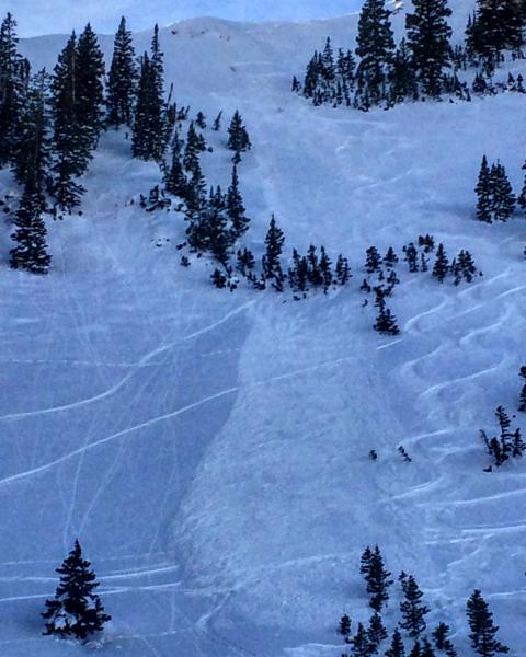
recent activity Avalanche activity yesterday ran the gamut of what we'd call Manageable (versus Unmanageable) Avalanche Problems -
|
| type | aspect/elevation | characteristics |
|---|

|

|
LIKELIHOOD
 LIKELY
UNLIKELY
SIZE
 LARGE
SMALL
TREND
 INCREASING DANGER
SAME
DECREASING DANGER
|
|
description
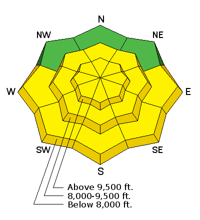
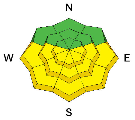
Plan on the increasing southwest winds to create shallow but sensitive wind drifts just to the lee of ridgelines, scoops, and convexities. These new drifts will be loaded on patchwork surface hoar and weak surface snow and therefore likely sensitive and potentially triggered from a distance. A quick note on the rose above - don't confuse mid-slope with mid-elevation. There may be many mid-elevation ridgelines (Reynolds Peak comes to mind) that would have a vastly different fetch or loading pattern than mid-slope Cardiac Bowl. |
| type | aspect/elevation | characteristics |
|---|

|
|
LIKELIHOOD
LIKELY
UNLIKELY
SIZE
 LARGE
SMALL
TREND
INCREASING DANGER
SAME
DECREASING DANGER
|
|
description
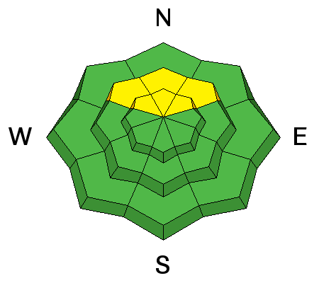
Should be the last day for any natural or human triggered wet activity for awhile. Crusts will soften sooner with the direct sun and temps already in the mid to upper 20s. Southwest winds should have an ameliorating effect, but wind protected terrain, particularly in concave solar oven bowls and gullies may tend to soften early and become unsupportable well before noon. |
| type | aspect/elevation | characteristics |
|---|

|
|
LIKELIHOOD
 LIKELY
UNLIKELY
SIZE
LARGE
SMALL
TREND
 INCREASING DANGER
SAME
DECREASING DANGER
|
|
description
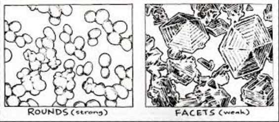
Hmm, snow metamorphism in three sentences or less. Tough task. When new snow falls, the shape of the individual snow crystal is often inherently unstable and - based upon many many factors (temperature, temperature gradient, porosity of the snow, etc) - tend to grow old and round and bond with their neighbors....or grow sharp and angular with showy facets but bond poorly with their neighbors. Sound familiar? The latter case happens often with clear, cold skies that drives this weakening process in the upper few inches of the snowpack...and because they don't bond so well, they become loose and sugary and sluff downhill on steep slopes with (and sometimes without) provocation. And remember, if it's super-weak now....wait til we put a new snow load on it and see what happens. Avalanche hunters will be back in business.
Habitat includes steep sun and wind sheltered terrain and typically becomes weaker and weaker over time. But, the skiing and riding quality remains quite good because you can still turn easily in the soft snow. My pals at the Hatcher Pass Avalanche Center Jed Workman and Allie Barker refer to it as "square powder" (because of the new shape of the snow crystals). Mike Clelland and Allen O'Bannon have written some great Really Cool books about the outdoors, including Allen and Mike's Avalanche Book, cartoons and images below -
|
 |
weather The ridge of high pressure will break down this evening ahead of a series of storms to impact northern Utah over the next several days. For today, we'll see temps at 10,000' and 8000' rising toward freezing and the low 40s, respectively. Southwesterlies will blow 20-25mph and likely increasing this evening before frontal passage. We might be able to squeeze a few inches from a moisture-starved system tonight and tomorrow, with perhaps a better looking wave rolling through Thursday night into Friday. Storm totals for the two could add up to 12-16" in favored locations. We get a brief break Saturday ahead of another set of storms perhaps late Saturday into Sunday and again Monday night. Details beyond Saturday should come into focus over the next couple of days. |
| general announcements Remember your information can save lives. If you see anything we should know about, please participate in the creation of our own community avalanche advisory by submitting snow and avalanche conditions. You can also call us at 801-524-5304, email by clicking HERE, or include #utavy in your tweet or Instagram. To get help in an emergency (to launch a rescue) in the Wasatch, call 911. Be prepared to give your GPS coordinates or the run name. Dispatchers have a copy of the Wasatch Backcountry Ski map. Backcountry Emergencies. It outlines your step-by-step method in the event of a winter backcountry incident. If you trigger an avalanche in the backcountry, but no one is hurt and you do not need assistance, please notify the nearest ski area dispatch to avoid a needless response by rescue teams. Thanks. Salt Lake and Park City – Alta Central (801-742-2033), Canyons Resort/PCMR Dispatch (435)615-1911 Snowbasin Resort Dispatch (801-620-1017), Powder Mountain Dispatch (801-745-3772 x 123). Sundance Dispatch (801-223-4150) EMAIL ADVISORY If you would like to get the daily advisory by email you will need to subscribe here. DAWN PATROL Hotline updated daily by 5-530am - 888-999-4019 option 8. Twitter Updates for your mobile phone - DETAILS UDOT canyon closures: LINK TO UDOT, or on Twitter, follow @UDOTavy, @CanyonAlerts or @AltaCentral Utah Avalanche Center mobile app - Get your advisory on your iPhone along with great navigation and rescue tools. Powderbird Helicopter Skiing - Blog/itinerary for the day Lost or Found something in the backcountry? - http://nolofo.com/ To those skinning uphill at resorts: it is your responsibility to know the resort policy on uphill travel. You can see the uphill travel policy for each resort here. IMPORTANT: Before skinning or hiking at a resort under new snow conditions, check in with Ski Patrol. Resorts can restrict or cut off access if incompatible with control and grooming operations. Benefit the Utah Avalanche Center when you shop from Backcountry.com or REI: Click this link for Backcountry.com or this link to REI, shop, and they will donate a percent of your purchase price to the UAC. Both offer free shipping (with some conditions) so this costs you nothing! Benefit the Utah Avalanche Center when you buy or sell on ebay - set the Utah Avalanche Center as a favorite non-profit in your ebay account here and click on ebay gives when you buy or sell. You can choose to have your seller fees donated to the UAC, which doesn't cost you a penny. This information does not apply to developed ski areas or highways where avalanche control is normally done. This advisory is from the U.S.D.A. Forest Service, which is solely responsible for its content. This advisory describes general avalanche conditions and local variations always exist. |