| Please join us at the 23rd annual Black Diamond Fall Fundraiser Party Thursday Sept 15. Tickets are on sale now here, at the Black Diamond store & at REI. Special bonus raffle for online ticket purchasers! |
| Please join us at the 23rd annual Black Diamond Fall Fundraiser Party Thursday Sept 15. Tickets are on sale now here, at the Black Diamond store & at REI. Special bonus raffle for online ticket purchasers! |
| Advisory: Salt Lake Area Mountains | Issued by Drew Hardesty for Tuesday - January 12, 2016 - 5:31am |
|---|

|
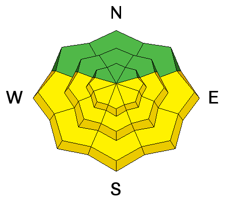
bottom line The danger remains at MODERATE in the backcountry for human triggered avalanches. Avalanche problems can be found all over the compass today and are almost too many to mention: dry and wet loose snow avalanches, wind slabs, and persistent/deep slabs. If this all sounds complicated, it's because it is right now. Remember that your trump card is slope angle. Your best bet is to find sun and wind sheltered terrain on slopes less steep than about 35 degrees with nothing steeper above.
|
 |
special announcement Announcing a Dutch Auction for a pair of 180 cm Vapor Nano Skis donated to the Utah Avalanche Center by La Sportiva. Here's an opportunity to learn a piece of economic trivia, practice your decision-making skills, benefit the Utah Avalanche Center, and smoke your friends up the skin track. These skis measure 130/103/120mm and weigh 1200 g (!). List price is $1,200. Here's the deal: We are offering these skis for sale to the first person that contacts us with a commitment to purchase (including their credit card information). The price today is $1,250. The price tomorrow (effective 12:00:01 am) will be $1,200. The price will continue to drop by $50 per day until someone buys the skis at that day's price or we decide the price has gone too low and end the auction with no sale. To ask questions or accept the current price, email us at [email protected]. We'll toss in a free UAC t-shirt or trucker hat and handful of Clif Bar product. For local pick up or we'll ship (you pay our shipping cost). No trades for size - we only have one pair. Two events coming up:
|
 |
current conditions Skies are clear. Mountain temperatures are in the teens along the ridgelines, the single digits in the basins and mountain valleys. The northwest winds - gusty out of the northwest yesterday - continue to blow 20-25mph with gusts in the 30s. These speeds and associated wind drifting seemed confined to the highest ridgelines. More protected anemometers are showing hourly wind speeds in the 10-15mph range. Out of the wind and sun damaged terrain, the riding conditions are sublime. |
 |
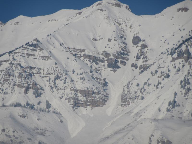
recent activity Recent activity from yesterday
|
| type | aspect/elevation | characteristics |
|---|

|
|
LIKELIHOOD
 LIKELY
UNLIKELY
SIZE
 LARGE
SMALL
TREND
 INCREASING DANGER
SAME
DECREASING DANGER
|
|
description
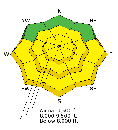
Soft and hard wind drifts will still be sensitive to human provocation (ski cuts, cornice drops and perhaps even on approach) along and just off the ridgelines today. These drifts are landing on a myriad of weak faceted grains, surface hoar, and low density snow and may be surprisingly reactive to human weight. They'll be more pronounced on north east to south facing slopes above about 9500'. Plumes noted off the highest peaks and ridgelines of the Wasatch range provide evidence of the drifting up high, but the drifting seemed localized to this topography. Those headed into more significant terrain should expect to either avoid or actively mitigate these new 12-18" drifts . |
| type | aspect/elevation | characteristics |
|---|

|
|
LIKELIHOOD
 LIKELY
UNLIKELY
SIZE
LARGE
SMALL
TREND
 INCREASING DANGER
SAME
DECREASING DANGER
|
|
description
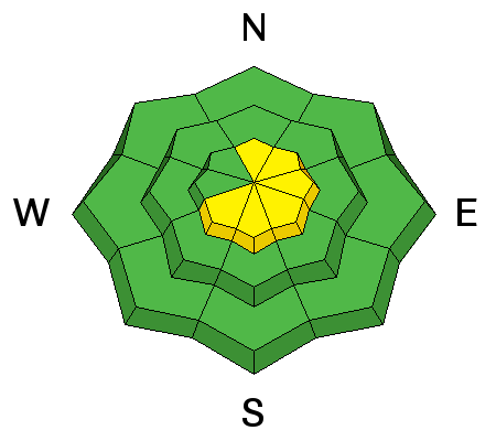
Natural and human-triggered wet sluffs and slabs are likely today on the steepest sunlit slopes. The window for decent travel on the steep southerlies is narrow - arrive too early to trip through the breakable sun crust...arrive too late to find yourself in damp-to-wet unsupportable wet glop. These wet avalanches may run longer than one might expect, owing to pre-storm slick sun crusts and "greased tracks" from previous longer running slides. Time your exits appropriately. |
| type | aspect/elevation | characteristics |
|---|

|

|
LIKELIHOOD
LIKELY
UNLIKELY
SIZE
LARGE
SMALL
TREND
INCREASING DANGER
SAME
DECREASING DANGER
|
|
description
Two issues here - having to do with the same basal facets from November
|
 |
weather We'll have mostly sunny skies and a few clouds north of I-80. Temps will rise to the mid to upper 20s at 10,000', the mid-to upper 30s at 8000'. West to northwest winds will continue in the 20-25mph range in the highest terrain; elsewhere expect 10-15mph hourly averages along the mid-elevation ridgelines. The ridge will begin to break down tomorrow afternoon, giving way to a series of progressive storms for later Thursday into next week. Thursday night into Friday looks fairly promising at this time with totals of perhaps 8-12". Stay tuned. |
| general announcements Remember your information can save lives. If you see anything we should know about, please participate in the creation of our own community avalanche advisory by submitting snow and avalanche conditions. You can also call us at 801-524-5304, email by clicking HERE, or include #utavy in your tweet or Instagram. To get help in an emergency (to launch a rescue) in the Wasatch, call 911. Be prepared to give your GPS coordinates or the run name. Dispatchers have a copy of the Wasatch Backcountry Ski map. Backcountry Emergencies. It outlines your step-by-step method in the event of a winter backcountry incident. If you trigger an avalanche in the backcountry, but no one is hurt and you do not need assistance, please notify the nearest ski area dispatch to avoid a needless response by rescue teams. Thanks. Salt Lake and Park City – Alta Central (801-742-2033), Canyons Resort/PCMR Dispatch (435)615-1911 Snowbasin Resort Dispatch (801-620-1017), Powder Mountain Dispatch (801-745-3772 x 123). Sundance Dispatch (801-223-4150) EMAIL ADVISORY If you would like to get the daily advisory by email you will need to subscribe here. DAWN PATROL Hotline updated daily by 5-530am - 888-999-4019 option 8. Twitter Updates for your mobile phone - DETAILS UDOT canyon closures: LINK TO UDOT, or on Twitter, follow @UDOTavy, @CanyonAlerts or @AltaCentral Utah Avalanche Center mobile app - Get your advisory on your iPhone along with great navigation and rescue tools. Powderbird Helicopter Skiing - Blog/itinerary for the day Lost or Found something in the backcountry? - http://nolofo.com/ To those skinning uphill at resorts: it is your responsibility to know the resort policy on uphill travel. You can see the uphill travel policy for each resort here. IMPORTANT: Before skinning or hiking at a resort under new snow conditions, check in with Ski Patrol. Resorts can restrict or cut off access if incompatible with control and grooming operations. Benefit the Utah Avalanche Center when you shop from Backcountry.com or REI: Click this link for Backcountry.com or this link to REI, shop, and they will donate a percent of your purchase price to the UAC. Both offer free shipping (with some conditions) so this costs you nothing! Benefit the Utah Avalanche Center when you buy or sell on ebay - set the Utah Avalanche Center as a favorite non-profit in your ebay account here and click on ebay gives when you buy or sell. You can choose to have your seller fees donated to the UAC, which doesn't cost you a penny. This information does not apply to developed ski areas or highways where avalanche control is normally done. This advisory is from the U.S.D.A. Forest Service, which is solely responsible for its content. This advisory describes general avalanche conditions and local variations always exist. |