| Please join us at the 23rd annual Black Diamond Fall Fundraiser Party Thursday Sept 15. Tickets are on sale now here, at the Black Diamond store & at REI. Special bonus raffle for online ticket purchasers! |
| Please join us at the 23rd annual Black Diamond Fall Fundraiser Party Thursday Sept 15. Tickets are on sale now here, at the Black Diamond store & at REI. Special bonus raffle for online ticket purchasers! |
| Advisory: Salt Lake Area Mountains | Issued by Evelyn Lees for Friday - January 8, 2016 - 6:42am |
|---|

|
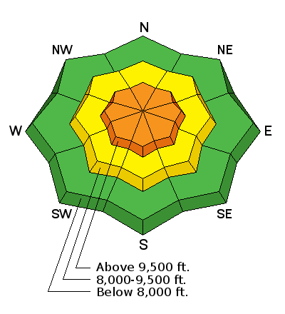
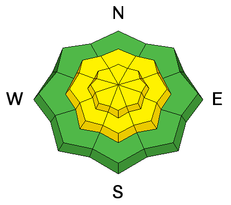
bottom line If the winds pick up, the Avalanche Danger will increase to CONSIDERABLE on any steep wind drifted slope. Out of the wind-affected terrain, the avalanche danger is MODERATE on all steep mid and upper elevations slopes, where a person can trigger new snow sluffs and soft slabs. There also remain a few isolated places where a person could trigger a larger avalanche breaking to the ground.
The safer, lower angle terrain provides excellent turning and riding conditions.
|
 |
current conditions Overnight wrap around moisture produced very even snow totals in the Park City, Salt Lake and Provo area mountains, adding 3 to 5” of moderately dense snow. The Ogden area mountains received a trace to an inch of snow overnight.
Multi-day snow totals are now up to 18” (1.2” water) in the Provo area mountains, a foot or so of snow with over an inch of water in the Cottonwoods and Ogden area mountains, and 6-8” along the Park City ridge line.
Skies are mostly cloudy this morning, and temperatures just a bit cooler – in the mid teens to low 20s. The northerly winds are very light, generally averaging around 5 miles per hour, though upper mountain stations remain rimed. |
 |
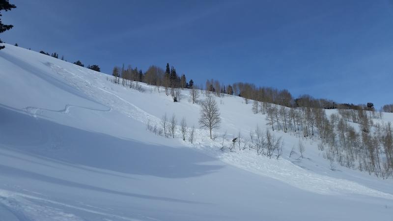
recent activity Overall poor bonding of the new snow on all aspects produced easily triggered long running, energetic sluffs and soft slabs throughout the range with ski cuts and explosives. The largest naturals were in the Provo area mountains. In Silver Fork, BCC, a skier triggered a slide in El Rollo, a repeater from December. An intentional ski cut released a small soft slab on north facing Little Superior Buttress, and a new snow natural was observed in Days Fork, about a foot deep by 100 feet wide. In addition, a small overnight natural cycle occurred in Little Cottonwood during the heavier snowfall. Find our complete statewide list of observations HERE. Below: El Rollo, Silver Fork, BCC
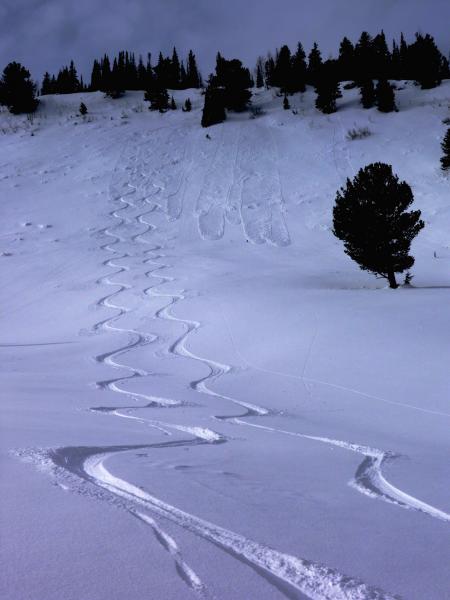
Below: Easily triggered sluffs, Park City ridge line
|
| type | aspect/elevation | characteristics |
|---|

|
|
LIKELIHOOD
 LIKELY
UNLIKELY
SIZE
 LARGE
SMALL
TREND
 INCREASING DANGER
SAME
DECREASING DANGER
|
|
description
I expect widespread new snow issues today, and exactly how rowdy it gets depends on the wind. If the winds increase into the forecast 15 to 20 mph range, I expect the snow to get very touchy and the danger to rapidly increase to CONSIDERABLE. The forecast wind speeds are just at the threshold where they could efficiently drift the snow. Be alert to any increase in wind speeds where you are in the backcountry, and avoid all wind drifts on steep slopes. |
| type | aspect/elevation | characteristics |
|---|

|
|
LIKELIHOOD
 LIKELY
UNLIKELY
SIZE
LARGE
SMALL
TREND
 INCREASING DANGER
SAME
DECREASING DANGER
|
|
description
The new snow is bonding poorly to the slick wind and sun crusts and to the sugary faceted snow that was on the surface. Even out of wind-drifted terrain, expect to trigger both soft slabs and sluffs today on slopes approaching 35 degrees and steeper. Some of these may run surprisingly long distances.
Most slopes that slid during the Christmas week avalanche cycle are now filled in with new snow. They are hard to identify, can be triggered again, and cannot be considered “safe”. |
| type | aspect/elevation | characteristics |
|---|

|
|
LIKELIHOOD
 LIKELY
UNLIKELY
SIZE
 LARGE
SMALL
TREND
INCREASING DANGER
SAME
DECREASING DANGER
|
|
description
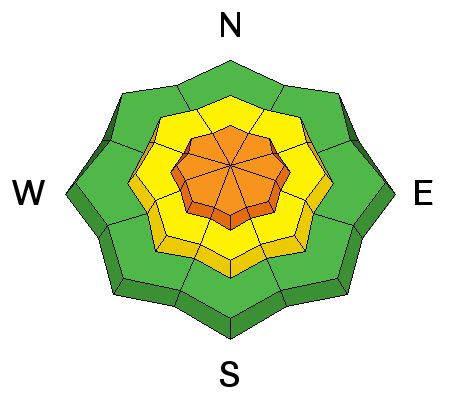
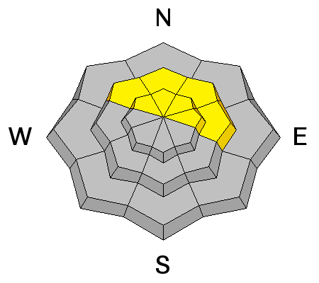
In isolated places a slide could still break on the weak facets near the ground, triggered by a person or perhaps a smaller new snow slide. Avoid steep, rocky terrain with a shallow snowpack on mid and upper elevation slopes facing northwest through easterly. |
 |
weather As the low finally moves off to the east, northern Utah will come under a moist, northwesterly flow today. Anticipate mostly cloudy skies today and tonight, with periods of very light snow, totaling an inch or two. The northwesterly winds will increase today, into the 10 to 20 mph range along the ridgelines. Temperatures will be in the upper teens to upper twenties. A few more snow flurries are possible tonight, before a break in the snow for the weekend, with partly cloudy skies. |
| general announcements Remember your information can save lives. If you see anything we should know about, please participate in the creation of our own community avalanche advisory by submitting snow and avalanche conditions. You can also call us at 801-524-5304, email by clicking HERE, or include #utavy in your tweet or Instagram. To get help in an emergency (to launch a rescue) in the Wasatch, call 911. Be prepared to give your GPS coordinates or the run name. Dispatchers have a copy of the Wasatch Backcountry Ski map. Backcountry Emergencies. It outlines your step-by-step method in the event of a winter backcountry incident. If you trigger an avalanche in the backcountry, but no one is hurt and you do not need assistance, please notify the nearest ski area dispatch to avoid a needless response by rescue teams. Thanks. Salt Lake and Park City – Alta Central (801-742-2033), Canyons Resort/PCMR Dispatch (435)615-1911 Snowbasin Resort Dispatch (801-620-1017), Powder Mountain Dispatch (801-745-3772 x 123). Sundance Dispatch (801-223-4150) EMAIL ADVISORY If you would like to get the daily advisory by email you will need to subscribe here. DAWN PATROL Hotline updated daily by 5-530am - 888-999-4019 option 8. Twitter Updates for your mobile phone - DETAILS UDOT canyon closures: LINK TO UDOT, or on Twitter, follow @UDOTavy, @CanyonAlerts or @AltaCentral Utah Avalanche Center mobile app - Get your advisory on your iPhone along with great navigation and rescue tools. Powderbird Helicopter Skiing - Blog/itinerary for the day Lost or Found something in the backcountry? - http://nolofo.com/ To those skinning uphill at resorts: it is your responsibility to know the resort policy on uphill travel. You can see the uphill travel policy for each resort here. IMPORTANT: Before skinning or hiking at a resort under new snow conditions, check in with Ski Patrol. Resorts can restrict or cut off access if incompatible with control and grooming operations. Benefit the Utah Avalanche Center when you shop from Backcountry.com or REI: Click this link for Backcountry.com or this link to REI, shop, and they will donate a percent of your purchase price to the UAC. Both offer free shipping (with some conditions) so this costs you nothing! Benefit the Utah Avalanche Center when you buy or sell on ebay - set the Utah Avalanche Center as a favorite non-profit in your ebay account here and click on ebay gives when you buy or sell. You can choose to have your seller fees donated to the UAC, which doesn't cost you a penny. This information does not apply to developed ski areas or highways where avalanche control is normally done. This advisory is from the U.S.D.A. Forest Service, which is solely responsible for its content. This advisory describes general avalanche conditions and local variations always exist. |