| Please join us at the 23rd annual Black Diamond Fall Fundraiser Party Thursday Sept 15. Tickets are on sale now here, at the Black Diamond store & at REI. Special bonus raffle for online ticket purchasers! |
| Please join us at the 23rd annual Black Diamond Fall Fundraiser Party Thursday Sept 15. Tickets are on sale now here, at the Black Diamond store & at REI. Special bonus raffle for online ticket purchasers! |
| Advisory: Salt Lake Area Mountains | Issued by Drew Hardesty for Sunday - December 20, 2015 - 6:06am |
|---|

|
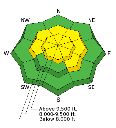
bottom line The danger is MODERATE for human triggered avalanches in the backcountry today and more pronounced on steep mid and upper elevation northwest to east facing slopes. If we get more snow than expected, watch for the usual shallow sluffs and wind drifts in steep terrain. The danger will be on the rise over the next several days. This week's storm has Avalanche Accident written all over it. Probably more than one. Combine heavy snow and wind, a rotten-to-the-core snowpack, Christmas vacation, and a hungry for powder Utah crowd. Along the arc of risk and desire lies the unwritten accident. Have a safe holiday season.
|
 |
avalanche watch THE FOREST SERVICE UTAH AVALANCHE CENTER IN SALT LAKE CITY HAS ISSUED A BACKCOUNTRY AVALANCHE WATCH. * TIMING...SUNDAY INTO SUNDAY NIGHT...THEN TRANSITIONING TO AN AVALANCHE WARNING BY LATER MONDAY. * AFFECTED AREA...ALL THE MOUNTAINS OF NORTHERN UTAH AND SOUTHEASTERN IDAHO, TO INCLUDE THE BEAR RIVER RANGE, THE WESTERN UINTAS AND THE MANTI-SKYLINE PLATEAU. * AVALANCHE DANGER...EXPECTED HEAVY SNOW AND STRONG WIND WILL PUSH THE DANGER TO HIGH AND PERHAPS EXTREME OVER THE NEXT SEVERAL DAYS. * IMPACTS...BY LATER MONDAY INTO TUESDAY, LARGE AND DANGEROUS NATURAL AND HUMAN TRIGGERED AVALANCHES WILL BE LIKELY. AVOID BEING IN STEEP TERRAIN OR BENEATH AVALANCHE RUNOUT ZONES. |
 |
special announcement The avalanche danger will be on the rise over the next several days. If you feel uncertain about your route finding, snow assessment, or rescue skills, it might be a good time to avoid the backcountry altogether. Consider riding the terrain at out world class mountain resorts instead - Buy discount lift tickets to Utah resorts and benefit the Utah Avalanche Center! Details here We've just produced a page called Backcountry Emergencies. It outlines your step-by-step method in the event of a winter backcountry incident. |
 |
current conditions Mark Friday December 18th on your calendar. I suspect that problems with Friday's translucent freezing rain crust will be far greater and more problematic than that of a simple breakable-crust annoyance for backcountry recreationists. More on this under Persistent Slab, below. Skies are overcast and it's lightly snowing in the mountains as a weak system moves overhead. The winds, mercifully, have calmed to a more reasonable 5-10mph from the west and northwest and mountain temperatures are now in the upper teens and low 20s. Dave Ream - now retired forest service ranger and once-upon-a-time UAC forecaster (you'll see him on our Staff page) - penned a nice avalanche poem worthy of the old days. |
 |
recent activity No activity reported from the backcountry yesterday. |
| type | aspect/elevation | characteristics |
|---|

|
|
LIKELIHOOD
 LIKELY
UNLIKELY
SIZE
 LARGE
SMALL
TREND
 INCREASING DANGER
SAME
DECREASING DANGER
|
|
description
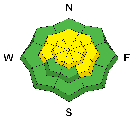
Currently, I view this as a low probability-high consequence scenario. Collapsing and cracking now are not prevalent and widespread, but rather varied and occasional. Explosive work at the ski areas aside, our last avalanches into old snow 2-3' deep (in the Wasatch Range anyway) ran on Thursday...and they've become increasingly stubborn to trigger over the last couple of days. Snowpit tests, however, still offer undeniable evidence that avalanches may still be possible in steep terrain and more pronounced on northwest to east facing slopes. If you're choosing to be in this terrain, set yourself up for success - or rather - minimize your insult-to-injury by asking yourself, "What will happen if I trigger an avalanche on this slope?". As always, it comes down to terrain - first avoidance and then consequence. Will the slide carry you down to an open meadow or will you get strained through trees and rag-dolled through stumps, over cliff-bands and through rocks? Down the road - my sense is that Friday's rain/rime crust will act as a bridge, allowing more and more weight to rest upon it until the whole snowpack fails catastrophically, leading to deeper, wider, more connected, and ultimately more dangerous avalanches. Tree snappers, you know? From an avalanche worker's perspective, this week will be very interesting. |
| type | aspect/elevation | characteristics |
|---|

|

|
LIKELIHOOD
 LIKELY
UNLIKELY
SIZE
 LARGE
SMALL
TREND
 INCREASING DANGER
SAME
DECREASING DANGER
|
|
description
Additional concerns include triggering a rogue stiff and stubborn hard wind drift associated with the strong pre-frontal winds. To be sure, there wasn't a great deal of snow to blow around due to Friday's superficial crust...but winds seem to find ways to erode crusts and drift exposed snow. Avoid any obvious smooth rounded whales of snow not capped by Friday's lens. Lastly, IF we get more snow than expected, you can expect the new snow to move - and pack a punch - on any steep terrain where the new snow falls on any exposed, slick crusts. |
 |
weather We'll see occasional snow throughout the day with light to moderate westerly winds and temps in the mid-teens. A series of storms embedded in a strong westerly flow begin tomorrow and lasting through early Thursday. 3-4' of snow is not out of the question. Heavy dense snow Monday and Tuesday along with strong westerly winds will be followed by a strong cold front early Wednesday, providing for additional snowfall with lower densities. Another system follows for later Thursday with high pressure nosing in for the weekend. |
| general announcements Remember your information can save lives. If you see anything we should know about, please participate in the creation of our own community avalanche advisory by submitting snow and avalanche conditions. You can also call us at 801-524-5304, email by clicking HERE, or include #utavy in your tweet or Instagram. To get help in an emergency (to launch a rescue) in the Wasatch, call 911. Be prepared to give your GPS coordinates or the run name. Dispatchers have a copy of the Wasatch Backcountry Ski map. Backcountry Emergencies. It outlines your step-by-step method in the event of a winter backcountry incident. If you trigger an avalanche in the backcountry, but no one is hurt and you do not need assistance, please notify the nearest ski area dispatch to avoid a needless response by rescue teams. Thanks. Salt Lake and Park City – Alta Central (801-742-2033), Canyons Resort/PCMR Dispatch (435)615-1911 Snowbasin Resort Dispatch (801-620-1017), Powder Mountain Dispatch (801-745-3772 x 123). Sundance Dispatch (801-223-4150) EMAIL ADVISORY If you would like to get the daily advisory by email you will need to subscribe here. DAWN PATROL Hotline updated daily by 5-530am - 888-999-4019 option 8. Twitter Updates for your mobile phone - DETAILS UDOT canyon closures: LINK TO UDOT, or on Twitter, follow @UDOTavy, @CanyonAlerts or @AltaCentral Utah Avalanche Center mobile app - Get your advisory on your iPhone along with great navigation and rescue tools. Wasatch Powderbird Guides Blog/Itinerary for the Day. Lost or Found something in the backcountry? - http://nolofo.com/ To those skinning uphill at resorts: it is your responsibility to know the resort policy on uphill travel. You can see the uphill travel policy for each resort here. IMPORTANT: Before skinning or hiking at a resort under new snow conditions, check in with Ski Patrol. Resorts can restrict or cut off access if incompatible with control and grooming operations. Benefit the Utah Avalanche Center when you shop from Backcountry.com or REI: Click this link for Backcountry.com or this link to REI, shop, and they will donate a percent of your purchase price to the UAC. Both offer free shipping (with some conditions) so this costs you nothing! Benefit the Utah Avalanche Center when you buy or sell on ebay - set the Utah Avalanche Center as a favorite non-profit in your ebay account here and click on ebay gives when you buy or sell. You can choose to have your seller fees donated to the UAC, which doesn't cost you a penny. This information does not apply to developed ski areas or highways where avalanche control is normally done. This advisory is from the U.S.D.A. Forest Service, which is solely responsible for its content. This advisory describes general avalanche conditions and local variations always exist. |


