| Please join us at the 23rd annual Black Diamond Fall Fundraiser Party Thursday Sept 15. Tickets are on sale now here, at the Black Diamond store & at REI. Special bonus raffle for online ticket purchasers! |
| Please join us at the 23rd annual Black Diamond Fall Fundraiser Party Thursday Sept 15. Tickets are on sale now here, at the Black Diamond store & at REI. Special bonus raffle for online ticket purchasers! |
| Advisory: Salt Lake Area Mountains | Issued by Evelyn Lees for Friday - December 18, 2015 - 6:29am |
|---|

|
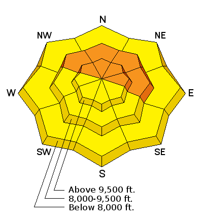
bottom line The avalanche danger is CONSIDERABLE on upper and mid elevation slopes facing northwest through easterly and steeper than about 30 degrees. Human triggered slides are likely, and can be triggered remotely from a distance. Other steep slopes have a MODERATE danger of triggering new snow slides, wind drifts or wet sluffs.
Low angle terrain is the place to recreate in the backcountry -whether you are riding, turning, snowshoeing or sledding.
|
 |
special announcement Deer Valley Empire area is closed to uphill traffic, as they will be doing explosive work.
Buy discount lift tickets to Utah resorts and benefit the Utah Avalanche Center! Details here |
 |
current conditions It is downright balmy out, with temperatures an astonishing 20 degrees warmer than yesterday morning. Most stations are in the 20s, and the southwesterly winds are light, less than 20 mph. In parts of the Salt Lake mountains, it’s precipitating a mix of frozen rain and rime, crusting the snow surface. Elsewhere, the snow has settled, and been thickened by the wind on many aspects and even crusted a bit on the steeper sunny slopes. |
 |
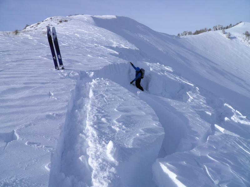
recent activity The Park City ridge line basically came unglued - naturals occurred overnight and midday in Dutch Draw, and slides were remotely triggered in No Name, Scotts, Radar Love and South Monitor (1000' wide by 4’ deep), all failing on facets near the ground. Isolated naturals occurring during the storm included south face of Superior, on Gobblers, the White Pine slide path, and in the Milly and Brighton Basins. Ski area avalanche reduction work in Little and Big Cottonwood released medium to large slab avalanches on all aspects above 9,000’, with the focus on northwest, north and northeasterly facing slopes. Left: South Monitor slide, Mark White photo Right: Scotts Bowl, Grant photo
|
| type | aspect/elevation | characteristics |
|---|

|
|
LIKELIHOOD
 LIKELY
UNLIKELY
SIZE
 LARGE
SMALL
TREND
 INCREASING DANGER
SAME
DECREASING DANGER
|
|
description
While there were some spectacular avalanches yesterday, unfortunately most slopes were left hanging once again. It’s a dangerous situation, as so many of the tempting slopes that didn’t slide could be triggered by a person. The steep slopes facing northwest through north through east are NOT the place to be – any slide triggered will break to the ground and go full track. Slides can be triggered from a distance or from below, and tracks on a slope are not a sign of stability. If you hear a collapsing or whoomphing sound, you are in the danger zone - get off of and out from under steep slopes. |
| type | aspect/elevation | characteristics |
|---|

|
|
LIKELIHOOD
 LIKELY
UNLIKELY
SIZE
 LARGE
SMALL
TREND
 INCREASING DANGER
SAME
DECREASING DANGER
|
|
description
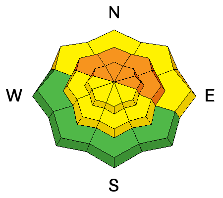
Rapid warming today may trigger wet sluffs at the lower elevations and on a few steep sunny slopes if the skies clear. Roofs may start to shed their snow in both the valleys and mountain towns, resulting in piles of snow deep enough to bury a person. |
 |
weather Once the rain/rime stops, it should be a pleasant break today, with gradually clearing skies and very warm temperatures – highs near 40 degrees at 8,000’ and near 30 at 10,000’. The southwesterly winds will remain moderate, averaging 15 to 25 mph, gusting in the 30s, with the highest peaks averaging to 35 mph. Overnight, the winds will ramp up ahead of the next storm that could give us a descent shot of snow Saturday night. Next week continues to look very stormy - warm, windy and wet, with periods of heavy snowfall. |
general announcements
|