| Please join us at the 23rd annual Black Diamond Fall Fundraiser Party Thursday Sept 15. Tickets are on sale now here, at the Black Diamond store & at REI. Special bonus raffle for online ticket purchasers! |
| Please join us at the 23rd annual Black Diamond Fall Fundraiser Party Thursday Sept 15. Tickets are on sale now here, at the Black Diamond store & at REI. Special bonus raffle for online ticket purchasers! |
| Advisory: Salt Lake Area Mountains | Issued by Evelyn Lees for Thursday - December 17, 2015 - 7:02am |
|---|

|
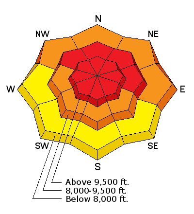
bottom line The avalanche danger is High on and below all upper elevation slopes steeper than about 30 degrees. Natural avalanches have occurred, and human triggered slides are very likely today. Both new wind drifts and slides breaking near the ground on weak facets could be triggered today. Backcountry travel in avalanche terrain is not recommended.
|
 |
avalanche warning An avalanche warning has been issued for all the mountains of northern Utah, including the western Uintas. Strong winds and heavy snowfall have created a HIGH avalanche danger. Both natural and human triggered avalanches are likely. Backcountry travel in avalanche terrain is not recommended. |
 |
current conditions Another wave of snow came through overnight, dropping up to 16” in the Provo area mountains and Little Cottonwood, and 5 to 9” in Big Cottonwood and the Ogden and Park City area mountains. Capping off a week of snow, storm totals are now in the 2 to 4 foot range. For the first time, the snow came with WIND, first from the southwest, currently from the northwest. At the mid elevations, speeds of 15 to 25 mph, with gusts in the 30s and 40s were common; the highest peaks have had averages to 50 mph, with gusts raging into the 80s. Temperatures are in the single digits to low teens this morning. |
 |
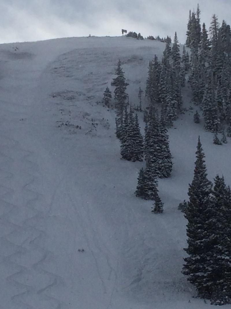
recent activity Overnight, a natural avalanche cycle occurred, including the south face of Superior with a debris pile 300’ wide and 3 feet deep and road banks releasing in the Provo area mountains.
Yesterday, a natural slide and explosive released slides on the Park City side broke to the ground, some running full track. Widespread collapsing and cracking was reported from parts of the Ogden areas mountains.
Photo below (by Andy Van Houten) of a Wednesday slide off Park City ridgeline, gouging to the ground and running full track.
|
| type | aspect/elevation | characteristics |
|---|

|
|
LIKELIHOOD
 LIKELY
UNLIKELY
SIZE
 LARGE
SMALL
TREND
 INCREASING DANGER
SAME
DECREASING DANGER
|
|
description
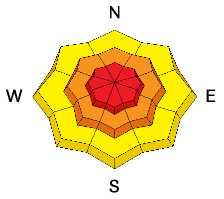
Strong winds from the southwest through northwest have blown and drifted huge amounts of snow, creating deep, sensitive drifts, both at the mid and upper elevations. Avoid all wind drifts. If you do trigger a wind slab, it will likely step down to the weak facets near the ground, especially on slopes facing northwest thorough southeasterly. This will create long running slides, going full track to the bottom of the slope. |
| type | aspect/elevation | characteristics |
|---|

|
|
LIKELIHOOD
 LIKELY
UNLIKELY
SIZE
LARGE
SMALL
TREND
INCREASING DANGER
SAME
DECREASING DANGER
|
|
description
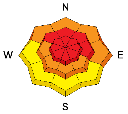
Our snowpack has been teetering on the edge for days, and the winds have finally tipped the balance. Natural slides stepping to the ground may have occurred. It should be expected that the additional weight of a person or any smaller slide on a steep slope will trigger a slide breaking into the sugary weak snow close to the ground. These slides would be deep and long running. If you hear a collapsing or whoomphing sound, it’s an indication the faceted weak layer has been overloaded where you are. Immediately get off of and out from under steep slopes – avalanches can be triggered from a distance with the sugary, faceted weak layers. |
 |
weather We should get a bit of a break today, with snow showers tapering off early this morning and the northwesterly winds decreasing into the 10 to 20 mph range. Across the highest peaks, winds will continue to gust into the 50s and 60s, and average near 40 mph. Temperatures will warm significantly, to near 20 degrees at 10,000’ by this evening. Winds will increase again late this afternoon, with light snow and rime tonight.
The stormy pattern will continue into next week, with a small shot of snow Saturday night into Sunday, and multiple wet, windy storms forecast for next week. |
| general announcements Remember your information can save lives. If you see anything we should know about, please participate in the creation of our own community avalanche advisory by submitting snow and avalanche conditions. You can also call us at 801-524-5304, email by clicking HERE, or include #utavy in your tweet or Instagram. To get help in an emergency (to launch a rescue) in the Wasatch, call 911. Be prepared to give your GPS coordinates or the run name. Dispatchers have a copy of the Wasatch Backcountry Ski map. If you trigger an avalanche in the backcountry, but no one is hurt and you do not need assistance, please notify the nearest ski area dispatch to avoid a needless response by rescue teams. Thanks. Salt Lake and Park City – Alta Central (801-742-2033), Canyons Resort/PCMR Dispatch (435)615-1911 Snowbasin Resort Dispatch (801-620-1017), Powder Mountain Dispatch (801-745-3772 x 123). Sundance Dispatch (801-223-4150) EMAIL ADVISORY If you would like to get the daily advisory by email you will need to subscribe here. DAWN PATROL Hotline updated daily by 5-530am - 888-999-4019 option 8. Twitter Updates for your mobile phone - DETAILS UDOT canyon closures: LINK TO UDOT, or on Twitter, follow @UDOTavy, @CanyonAlerts or @AltaCentral Utah Avalanche Center mobile app - Get your advisory on your iPhone along with great navigation and rescue tools. Wasatch Powderbird Guides Blog/Itinerary for the Day. Lost or Found something in the backcountry? - http://nolofo.com/ To those skinning uphill at resorts: it is your responsibility to know the resort policy on uphill travel. You can see the uphill travel policy for each resort here. IMPORTANT: Before skinning or hiking at a resort under new snow conditions, check in with Ski Patrol. Resorts can restrict or cut off access if incompatible with control and grooming operations. Benefit the Utah Avalanche Center when you shop from Backcountry.com or REI: Click this link for Backcountry.com or this link to REI, shop, and they will donate a percent of your purchase price to the UAC. Both offer free shipping (with some conditions) so this costs you nothing! Benefit the Utah Avalanche Center when you buy or sell on ebay - set the Utah Avalanche Center as a favorite non-profit in your ebay account here and click on ebay gives when you buy or sell. You can choose to have your seller fees donated to the UAC, which doesn't cost you a penny. This information does not apply to developed ski areas or highways where avalanche control is normally done. This advisory is from the U.S.D.A. Forest Service, which is solely responsible for its content. This advisory describes general avalanche conditions and local variations always exist. |