| Please join us at the 23rd annual Black Diamond Fall Fundraiser Party Thursday Sept 15. Tickets are on sale now here, at the Black Diamond store & at REI. Special bonus raffle for online ticket purchasers! |
| Please join us at the 23rd annual Black Diamond Fall Fundraiser Party Thursday Sept 15. Tickets are on sale now here, at the Black Diamond store & at REI. Special bonus raffle for online ticket purchasers! |
| Advisory: Salt Lake Area Mountains | Issued by Drew Hardesty for Sunday - December 13, 2015 - 7:06am |
|---|

|
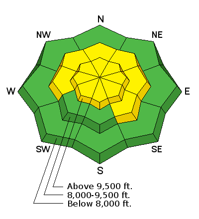
bottom line The overall danger is MODERATE for new and developing wind drifts today. These may be most pronounced on steep north to east to southerly slopes at the mid and upper elevations. For those heading into the north westerly to east facing slopes, any newly triggered wind drift may step down into older, weaker snow 1-2' deep. Cracking and collapsing should be a red light today. The danger will be on the rise over the next several days.
|
 |
avalanche watch THE FOREST SERVICE UTAH AVALANCHE CENTER IN SALT LAKE CITY HAS ISSUED A BACKCOUNTRY AVALANCHE WATCH. * TIMING...STARTING MONDAY MORNING, DANGEROUS AVALANCHE CONDITIONS ARE EXPECTED OVER THE NEXT SEVERAL DAYS. * AFFECTED AREA...ALL THE MOUNTAINS OF NORTHERN AND CENTRAL UTAH, INCLUDING THE BEAR RIVER RANGE, THE WESTERN UINTAS AND THE WASATCH PLATEAU. * AVALANCHE DANGER...THE DANGER IS EXPECTED TO RISE SIGNIFICANTLY WITH THE ADDITIONAL SNOW AND WIND. * IMPACTS...DANGEROUS HUMAN TRIGGERED AVALANCHES ARE EXPECTED ON A VARIETY OF ASPECTS AND ELEVATIONS.
|
 |
special announcement
Confused on a the difference between an Avalanche Watch and an Avalanche Warning? You're not alone. Simply, an Avalanche Watch implies that we expect dangerous conditions soon...an Avalanche Warning implies that dangerous avalanche conditions currently exist. You can read a touch more on a Blog we put together here - |
 |
current conditions With the storm approaching....skies are partly cloudy, temps are in the teens and rising, winds are westerly and blowing 15-20mph with gusts to 30. Along the highest ridgelines, winds are already blowing 30mph with gusts to 40. We sit at roughly 60% of average snow-water-equivalent for the year....and total snow depths are 1-2' in the backcountry.
|
 |
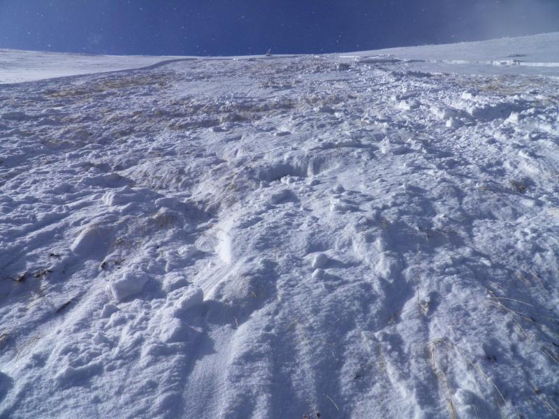
recent activity A very experienced backcountry skier unintentionally triggered an 8" deep and 60' wide avalanche in South Monitor bowl along the Park City ridgeline. The slide - mostly east facing at 9800' - collapsed a couple crusts, running on early December faceted snow and broke 30' above him after his fourth turn on the slope. The slide eventually stepped down to the ground as it ran down toward the flats below. Fortunately, he was not caught or carried, only surprised. He wasn't the only one surprised. You can read more about the close call here - (photo - White) A quick word on this - I tip my hat to this observer - this information is critical and key for us and the community and saves lives. Sometimes ego or hubris prevents people from sharing this information and it's a shame. None of us - particularly forecasters - can throw stones at glass houses.
|
| type | aspect/elevation | characteristics |
|---|

|
|
LIKELIHOOD
 LIKELY
UNLIKELY
SIZE
 LARGE
SMALL
TREND
 INCREASING DANGER
SAME
DECREASING DANGER
|
|
description
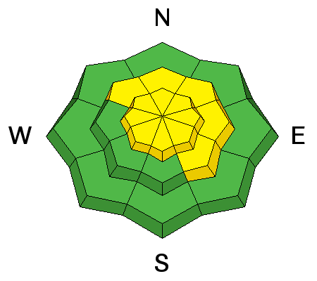
Sensitive wind drifts will start to develop over the day as the pre-frontal winds erode and then deposit Thursday night's 5" storm into various and myriad steep starting zones. I don't expect them to bond particularly well with not only the top of the 5", but the trace to an inch of new we've seen over the past 36 hours. |
| type | aspect/elevation | characteristics |
|---|

|
|
LIKELIHOOD
 LIKELY
UNLIKELY
SIZE
LARGE
SMALL
TREND
INCREASING DANGER
SAME
DECREASING DANGER
|
|
description
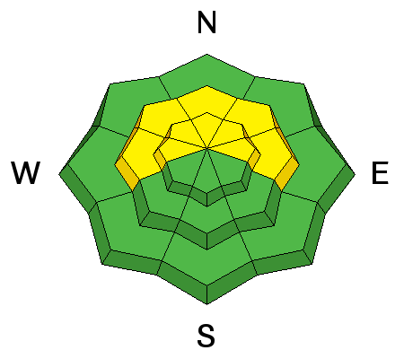
The slide in South Monitor yesterday may have been a portent of things to come. With the weight of additional snow and wind, any triggered wind drift on west to north to east facing slopes may step down to the very weak snow at either the mid-pack or down to the ground. Adding insult to injury is that these avalanches may be triggered remotely - that is, at a distance - and may break out well above you on the slope. Collapsing is a sure-fire sign that things are beginning to tip... |
 |
weather What looks to be a decent storm is on our doorstep. For today, we'll have partly cloudy skies, increasing temps and winds ahead of tomorrow morning's cold front. Temps will rise to the mid to upper 20s; the winds should continue backing to the west and southwest, eventually blowing 25-35mph with gusts to near 50. A burst of snow will accompany the cold front tomorrow morning and snow levels will reach the valleys. The slow moving storm lingers though Tuesday night/Wednesday morning with conservative snow totals expected in the 10-16" range. Temps will drop to the upper single digits to low teens by late Monday. With a brief break, it looks like a warm front and associated winds, precipitation, and possibly riming arrives later Thursday. I'll take a closer look at the weather and update our Mountain Weather forecast by early afternoon. |
| general announcements Remember your information can save lives. If you see anything we should know about, please participate in the creation of our own community avalanche advisory by submitting snow and avalanche conditions. You can also call us at 801-524-5304, email by clicking HERE, or include #utavy in your tweet or Instagram. To get help in an emergency (to launch a rescue) in the Wasatch, call 911. Be prepared to give your GPS coordinates or the run name. Dispatchers have a copy of the Wasatch Backcountry Ski map. If you trigger an avalanche in the backcountry, but no one is hurt and you do not need assistance, please notify the nearest ski area dispatch to avoid a needless response by rescue teams. Thanks. Salt Lake and Park City – Alta Central (801-742-2033), Canyons Resort/PCMR Dispatch (435)615-1911 Snowbasin Resort Dispatch (801-620-1017), Powder Mountain Dispatch (801-745-3772 x 123). Sundance Dispatch (801-223-4150) EMAIL ADVISORY If you would like to get the daily advisory by email you will need to subscribe here. DAWN PATROL Hotline updated daily by 5-530am - 888-999-4019 option 8. Twitter Updates for your mobile phone - DETAILS UDOT canyon closures: LINK TO UDOT, or on Twitter, follow @UDOTavy, @CanyonAlerts or @AltaCentral Utah Avalanche Center mobile app - Get your advisory on your iPhone along with great navigation and rescue tools. Wasatch Powderbird Guides Blog/Itinerary for the Day. Lost or Found something in the backcountry? - http://nolofo.com/ To those skinning uphill at resorts: it is your responsibility to know the resort policy on uphill travel. You can see the uphill travel policy for each resort here. IMPORTANT: Before skinning or hiking at a resort under new snow conditions, check in with Ski Patrol. Resorts can restrict or cut off access if incompatible with control and grooming operations. Benefit the Utah Avalanche Center when you shop from Backcountry.com or REI: Click this link for Backcountry.com or this link to REI, shop, and they will donate a percent of your purchase price to the UAC. Both offer free shipping (with some conditions) so this costs you nothing! Benefit the Utah Avalanche Center when you buy or sell on ebay - set the Utah Avalanche Center as a favorite non-profit in your ebay account here and click on ebay gives when you buy or sell. You can choose to have your seller fees donated to the UAC, which doesn't cost you a penny. This information does not apply to developed ski areas or highways where avalanche control is normally done. This advisory is from the U.S.D.A. Forest Service, which is solely responsible for its content. This advisory describes general avalanche conditions and local variations always exist. |