| Please join us at the 23rd annual Black Diamond Fall Fundraiser Party Thursday Sept 15. Tickets are on sale now here, at the Black Diamond store & at REI. Special bonus raffle for online ticket purchasers! |
| Please join us at the 23rd annual Black Diamond Fall Fundraiser Party Thursday Sept 15. Tickets are on sale now here, at the Black Diamond store & at REI. Special bonus raffle for online ticket purchasers! |
| Advisory: Salt Lake Area Mountains | Issued by Mark Staples for Monday - December 7, 2015 - 6:21am |
|---|

|
bottom line The avalanche danger is LOW. Some small wind slabs could be triggered but the main hazard remains hitting rocks and stumps.
|
 |
special announcement TODAY the UDOT Avalanche Program will be testing their howitzer in Provo Canyon. Expect intermittent closures on US-189 from 10:30am to 12:00pm between Canyon Glen and Vivian Park. Rather than being out in the field watching facets grow on Wednesday afternoon, those of you with an interest in snow science might want to attend a seminar that will be given at the U by Jordy Hendrikx titled “Snow Science: Taking a Multi-Faceted Approach to Understand Avalanches.” Since it’s not snowing, consider attending an avalanche awareness class or beacon clinic. Classes this week are full, but there are several next week with space available that are worth attending. Go HERE for a list of classes. We will issue the next advisory Wednesday morning. |
 |
current conditions This morning, mountain temperatures were in the upper 20s to low 30s F. Winds were averaging 15 mph with gusts 20-30 mph generally from the WSW. On most slopes the snowpack continues to facet and weaken. The exception is on south aspects where there is either no snow or very thin snow that has gotten wet and refrozen during the last few days. On a south-east facing slope at 10,000 feet yesterday overlooking Snake Creek, I found warm wet snow, BUT the slightest change in slope orientation limited warming from the sun, and the snowpack was completely weak and faceted. The point is that the slightest change in slope orientation can make a huge difference. When more snow comes, we can make assumptions based on aspect and elevation as to what the new snow is resting on, but digging to the ground will be the only way to know for sure. |
 |
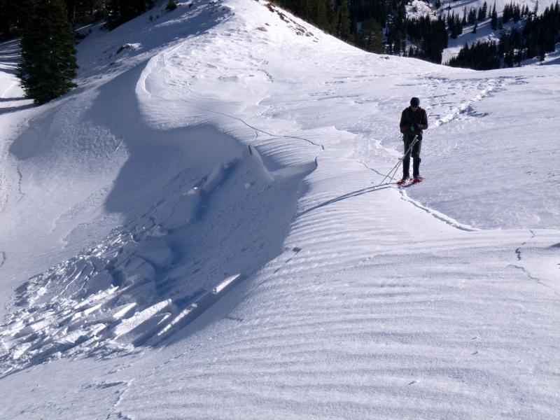
recent activity The only recent avalanche activity has been very small wind slabs. While not a major concern at the moment, they are giving us a heads up of things to come. Observers in White Pine Fork near Lake Peak experience cracking wind slabs on north aspects, some about 15 feet wide and 6 inches deep. Other folks in Cardiff Fork near Montreal Hill yesterday triggered a small wind slab (photo below). Notice the crack that is 3X as wide as the wind slab that released. This cracking tells me that the wind drift was resting on weak, faceted snow. It is a warning of things to come when more snow falls and builds a slab on top of the current snowpack.
Photo: G. Lott |
| type | aspect/elevation | characteristics |
|---|

|
|
LIKELIHOOD
 LIKELY
UNLIKELY
SIZE
 LARGE
SMALL
TREND
 INCREASING DANGER
SAME
DECREASING DANGER
|
|
description
Wind slabs are the only avalanche problem today. They should be pretty small as seen in the photo above, but you could still trigger one because many of them rest on faceted snow. |
 |
weather A westerly flow today will bring increased winds late this afternoon that could gust in the 40s. Clouds will increase and temperatures shouldn’t warm much above freezing. Tonight a small disturbance will bring a few flurries to the central Wasatch mountains while the mountains near Logan could get an inch of snow. More snow should be on the way Thursday evening and through the weekend. Do you feel like we keep promising more snow in the long range forecasts? We've gotta keep the hope alive. Check out this VIDEO from Environment Canada about the promise of warm weather in the 7 day forecasts. Perhaps the chance of emerging from the deep freeze for them is like the chance of snowfall for us. |
| general announcements Remember your information can save lives. If you see anything we should know about, please participate in the creation of our own community avalanche advisory by submitting snow and avalanche conditions. You can also call us at 801-524-5304, email by clicking HERE, or include #utavy in your tweet or Instagram. To get help in an emergency (to launch a rescue) in the Wasatch, call 911. Be prepared to give your GPS coordinates or the run name. Dispatchers have a copy of the Wasatch Backcountry Ski map. If you trigger an avalanche in the backcountry, but no one is hurt and you do not need assistance, please notify the nearest ski area dispatch to avoid a needless response by rescue teams. Thanks. Salt Lake and Park City – Alta Central (801-742-2033), Canyons Resort/PCMR Dispatch (435)615-1911 Snowbasin Resort Dispatch (801-620-1017), Powder Mountain Dispatch (801-745-3772 x 123). Sundance Dispatch (801-223-4150) EMAIL ADVISORY If you would like to get the daily advisory by email you will need to subscribe here. DAWN PATROL Hotline updated daily by 5-530am - 888-999-4019 option 8. Twitter Updates for your mobile phone - DETAILS UDOT canyon closures: LINK TO UDOT, or on Twitter, follow @UDOTavy, @CanyonAlerts or @AltaCentral Utah Avalanche Center mobile app - Get your advisory on your iPhone along with great navigation and rescue tools. Wasatch Powderbird Guides Blog/Itinerary for the Day. Lost or Found something in the backcountry? - http://nolofo.com/ To those skinning uphill at resorts: it is your responsibility to know the resort policy on uphill travel. You can see the uphill travel policy for each resort here. IMPORTANT: Before skinning or hiking at a resort under new snow conditions, check in with Ski Patrol. Resorts can restrict or cut off access if incompatible with control and grooming operations. Benefit the Utah Avalanche Center when you shop from Backcountry.com or REI: Click this link for Backcountry.com or this link to REI, shop, and they will donate a percent of your purchase price to the UAC. Both offer free shipping (with some conditions) so this costs you nothing! Benefit the Utah Avalanche Center when you buy or sell on ebay - set the Utah Avalanche Center as a favorite non-profit in your ebay account here and click on ebay gives when you buy or sell. You can choose to have your seller fees donated to the UAC, which doesn't cost you a penny. This information does not apply to developed ski areas or highways where avalanche control is normally done. This advisory is from the U.S.D.A. Forest Service, which is solely responsible for its content. This advisory describes general avalanche conditions and local variations always exist. |