| Please join us at the 23rd annual Black Diamond Fall Fundraiser Party Thursday Sept 15. Tickets are on sale now here, at the Black Diamond store & at REI. Special bonus raffle for online ticket purchasers! |
| Please join us at the 23rd annual Black Diamond Fall Fundraiser Party Thursday Sept 15. Tickets are on sale now here, at the Black Diamond store & at REI. Special bonus raffle for online ticket purchasers! |
| Advisory: Salt Lake Area Mountains | Issued by Drew Hardesty for Saturday - December 5, 2015 - 5:51am |
|---|

|
bottom line The overall danger is mostly LOW. Isolated hard wind drifts may be found in the highest alpine terrain. Remember that risk is always inherent in mountain travel. Currently, the main hazard is the thinly veiled collection of trees, stumps, and deadfall lying beneath and among 1-2' of snow on the ground. This advisory will be valid through Sunday evening. We'll continue to issue advisories as conditions warrant.
|
 |
special announcement The Fireside Chats at Black Diamond are gearing up again this winter. Come down to the store Wednesday December 16th at 7:30pm. Retired head of the SLC National Weather Service and die-hard backcountry skier (and not necessarily in that order) Larry Dunn and I will present what BD is calling "Predict the Pow - tips and tricks for aspiring and dirtbag meteorologists".
|
 |
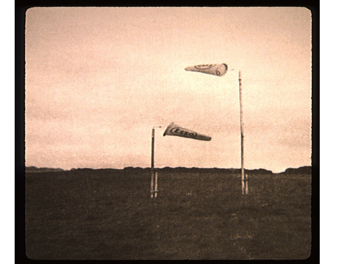
current conditions Skies are clearing in the wake of the cold front and mountain temperatures sit in the mid-teens. Winds are in check and are generally from the west and northwest at less than 15mph. One might look around and feel short-changed by the storm, but careful analysis of the instrumentation data shows that at around 8pm or so last night we did indeed pick up .01" of precipitation. Total snow depths, however, remain in the 1-2' range and serve to veil the rocks, stumps, and deadfall.
|
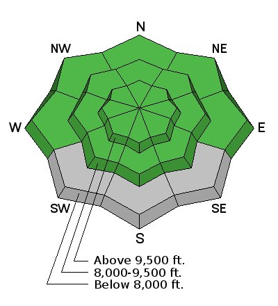
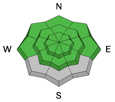
| type | aspect/elevation | characteristics |
|---|

|
|
LIKELIHOOD
 LIKELY
UNLIKELY
SIZE
 LARGE
SMALL
TREND
 INCREASING DANGER
SAME
DECREASING DANGER
|
|
description
Very isolated hard wind pillows may be encountered in the high alpine terrain today; otherwise, the danger is mostly Low. The snowpack continues to rot from the bottom up and the top down. At some point, however, we'll see a storm - as death, taxes, and snow in the Wasatch can't be denied. And when it does snow, it'll be a game changer. We'll continue to issue just intermittent advisories through next week. Daily observations will continue to be found here. |
 |
weather We'll see briefly clearing skies ahead of another storm slated for tomorrow night. Southwest winds will pick up during the day tomorrow, but I don't think we'll get as much snow as this last storm. The Logan area mountains may see a touch of snow with this and another disturbance on Monday night. For today, temps will be in the upper 20s to low 30s. Winds will be generally light from the west. Medium range weather: 10,000' temperatures will flirt with the 0°C isotherm over the next several days...models suggest a large scale pattern change that may produce some snow for Thursday>weekend. |
| general announcements
Remember your information can save lives. If you see anything we should know about, please participate in the creation of our own community avalanche advisory by submitting snow and avalanche conditions. You can also call us at 801-524-5304, email by clicking HERE, or include #utavy in your tweet or Instagram. To get help in an emergency (to launch a rescue) in the Wasatch, call 911. Be prepared to give your GPS coordinates or the run name. Dispatchers have a copy of the Wasatch Backcountry Ski map. If you trigger an avalanche in the backcountry, but no one is hurt and you do not need assistance, please notify the nearest ski area dispatch to avoid a needless response by rescue teams. Thanks. Salt Lake and Park City – Alta Central (801-742-2033), Canyons Resort/PCMR Dispatch (435)615-1911 Snowbasin Resort Dispatch (801-620-1017), Powder Mountain Dispatch (801-745-3772 x 123). Sundance Dispatch (801-223-4150) EMAIL ADVISORY If you would like to get the daily advisory by email you will need to subscribe here. DAWN PATROL Hotline updated daily by 5-530am - 888-999-4019 option 8. Twitter Updates for your mobile phone - DETAILS UDOT canyon closures: LINK TO UDOT, or on Twitter, follow @UDOTavy, @CanyonAlerts or @AltaCentral Utah Avalanche Center mobile app - Get your advisory on your iPhone along with great navigation and rescue tools. Wasatch Powderbird Guides Blog/Itinerary for the Day. Lost or Found something in the backcountry? - http://nolofo.com/ To those skinning uphill at resorts: it is your responsibility to know the resort policy on uphill travel. You can see the uphill travel policy for each resort here. IMPORTANT: Before skinning or hiking at a resort under new snow conditions, check in with Ski Patrol. Resorts can restrict or cut off access if incompatible with control and grooming operations. Benefit the Utah Avalanche Center when you shop from Backcountry.com or REI: Click this link for Backcountry.com or this link to REI, shop, and they will donate a percent of your purchase price to the UAC. Both offer free shipping (with some conditions) so this costs you nothing! Benefit the Utah Avalanche Center when you buy or sell on ebay - set the Utah Avalanche Center as a favorite non-profit in your ebay account here and click on ebay gives when you buy or sell. You can choose to have your seller fees donated to the UAC, which doesn't cost you a penny. This information does not apply to developed ski areas or highways where avalanche control is normally done. This advisory is from the U.S.D.A. Forest Service, which is solely responsible for its content. This advisory describes general avalanche conditions and local variations always exist. |