| Please join us at the 23rd annual Black Diamond Fall Fundraiser Party Thursday Sept 15. Tickets are on sale now here, at the Black Diamond store & at REI. Special bonus raffle for online ticket purchasers! |
| Please join us at the 23rd annual Black Diamond Fall Fundraiser Party Thursday Sept 15. Tickets are on sale now here, at the Black Diamond store & at REI. Special bonus raffle for online ticket purchasers! |
| Advisory: Salt Lake Area Mountains | Issued by Drew Hardesty for Wednesday - November 25, 2015 - 6:21am |
|---|

|
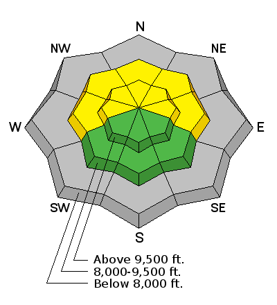
bottom line Most terrain harbors a Low avalanche danger. Localized areas of MODERATE danger exist, however, due to the strong southerly winds over the past 36 hours or so. The main concern centers around the potential for triggering pockety wind drifts and then being raked through the rocks and deadfall of our vertically challenged snowpack. The best and safest riding conditions remain on upper elevation wind and sun sheltered low angled terrain.
|
 |
special announcement Most ski areas are closed to uphill traffic as they open or prepare to open. Check in at each resort for their current early season uphill policy. Our classes are filling up - check out our Education schedule (click Education on the menu bar above) to learn more about what the UAC offers and how to sign up. |
 |
current conditions I wouldn't exactly call it the calm before the storm. Skies are partly cloudy, temps are in the upper 20s to low 30s, and the southerly winds continue to hammer the Wasatch Range with hourly averages in the 35-45mph range with gusts to 50. An upper level Low pressure system just to the west of us (water vapor satellite image below) will move languidly in and overhead through the holiday weekend, though expected snow amounts look to be underwhelming. Current snow depths range from 1-2' with snow surfaces a mixed bag of wind, sun, and rain/rime crust amid patches of soft, spongy graupel.
|
 |
recent activity No activity of note. |
| type | aspect/elevation | characteristics |
|---|

|

|
LIKELIHOOD
 LIKELY
UNLIKELY
SIZE
 LARGE
SMALL
TREND
 INCREASING DANGER
SAME
DECREASING DANGER
|
|
description
The danger may look to be more significant and widespread than it really is. Still two scenarios exist over the next several days. I am more concerned with the current wind drifting and cross-loading now than with what looks to be storm totals of 5-10" built up over several days.* There is some uncertainty in today's forecast, but the key would be to look for fresh, rounded, chalky deposits of snow in steep terrain both in the upper and mid elevations...and avoid them altogether. They'll be more pronounced on west to north to east facing terrain and not limited to the lee of ridgelines. Extra Caution:
* A good deal of uncertainty lies with the snow amounts.... |
 |
weather As the storm moves overhead, the winds will rapidly diminish and temperatures will drop into the teens. We'll see a touch of precipitation later today with followed by a "burst" of snowfall with frontal passage in the early evening. We may see 3-6" tonight with dribs and drabs of additional snow through the weekend. It may all add up to 5-10" by late Sunday. Did I mention confidence level is low with this storm? At least one weather model depicts continued quick moving storms rolling in from the west next week. |
| general announcements
Remember your information can save lives. If you see anything we should know about, please participate in the creation of our own community avalanche advisory by submitting snow and avalanche conditions. You can also call us at 801-524-5304, email by clicking HERE, or include #utavy in your tweet or Instagram. To get help in an emergency (to launch a rescue) in the Wasatch, call 911. Be prepared to give your GPS coordinates or the run name. Dispatchers have a copy of the Wasatch Backcountry Ski map. If you trigger an avalanche in the backcountry, but no one is hurt and you do not need assistance, please notify the nearest ski area dispatch to avoid a needless response by rescue teams. Thanks. Salt Lake and Park City – Alta Central (801-742-2033), Canyons Resort/PCMR Dispatch (435)615-1911 Snowbasin Resort Dispatch (801-620-1017), Powder Mountain Dispatch (801-745-3772 x 123). Sundance Dispatch (801-223-4150) EMAIL ADVISORY If you would like to get the daily advisory by email you will need to subscribe here. DAWN PATROL Hotline updated daily by 5-530am - 888-999-4019 option 8. Twitter Updates for your mobile phone - DETAILS UDOT canyon closures: LINK TO UDOT, or on Twitter, follow @UDOTavy, @CanyonAlerts or @AltaCentral Utah Avalanche Center mobile app - Get your advisory on your iPhone along with great navigation and rescue tools. Wasatch Powderbird Guides Blog/Itinerary for the Day. Lost or Found something in the backcountry? - http://nolofo.com/ To those skinning uphill at resorts: it is your responsibility to know the resort policy on uphill travel. You can see the uphill travel policy for each resort here. IMPORTANT: Before skinning or hiking at a resort under new snow conditions, check in with Ski Patrol. Resorts can restrict or cut off access if incompatible with control and grooming operations. Benefit the Utah Avalanche Center when you shop from Backcountry.com or REI: Click this link for Backcountry.com or this link to REI, shop, and they will donate a percent of your purchase price to the UAC. Both offer free shipping (with some conditions) so this costs you nothing! Benefit the Utah Avalanche Center when you buy or sell on ebay - set the Utah Avalanche Center as a favorite non-profit in your ebay account here and click on ebay gives when you buy or sell. You can choose to have your seller fees donated to the UAC, which doesn't cost you a penny. This information does not apply to developed ski areas or highways where avalanche control is normally done. This advisory is from the U.S.D.A. Forest Service, which is solely responsible for its content. This advisory describes general avalanche conditions and local variations always exist. |


