| Please join us at the 23rd annual Black Diamond Fall Fundraiser Party Thursday Sept 15. Tickets are on sale now here, at the Black Diamond store & at REI. Special bonus raffle for online ticket purchasers! |
| Please join us at the 23rd annual Black Diamond Fall Fundraiser Party Thursday Sept 15. Tickets are on sale now here, at the Black Diamond store & at REI. Special bonus raffle for online ticket purchasers! |
| Advisory: Salt Lake Area Mountains | Issued by Mark Staples for Tuesday - November 10, 2015 - 5:28am |
|---|

|
bottom line 8:00 a.m UPDATE: An unexpected band of snowfall has appeared over the Cottonwoods with snow totals now 3-6 inches. If this band of snowfall remains in place, another 3-6 inches could fall. This snow combined with southerly winds could form soft slabs on northerly aspects where these slabs will not bond well with the faceted snow underneath. With such little snow, the primary danger is hitting rocks and stumps and the avalanche danger is LOW. Until more snow comes, we will be issuing intermittent advisories that will be updated with each storm.
|
 |
special announcement Snowbird is closed to uphill traffic due to mountain operations. Maybe open later this week - check with patrol for latest news. |
 |
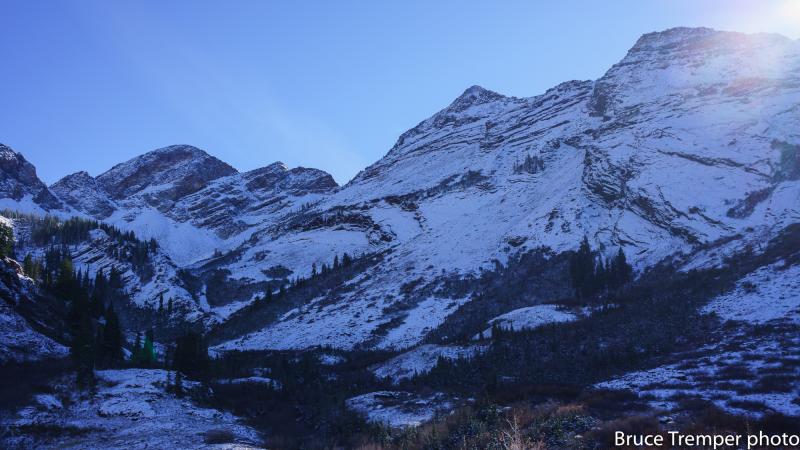
current conditions A frontal boundary stalled to the north of the central Wasatch and limited snowfall to only about an inch of snow at Alta and 3 inches at Brighton. Further north near Farmington and Snowbasin, 2-6 inches of snow fell under the frontal boundary. S and SE winds yesterday were blowing 20-40 mph but eased overnight and shifted to the SW. New snow fell on a variety of snow surfaces containing thin wind slabs, facets and some surface hoar. Northerly aspects above 9500 feet have the most consistent snow cover with about 6-8 inches on the ground. Yesterday, both Drew and Evelyn found plenty of weak, faceted snow. With little additional snow coming and more clear, cold nights, today's new snow should experience strong temperature gradients and will also become faceted, providing another weak layer and a future avalanche problem when we get a decent load of new snow. Upper Broads Fork
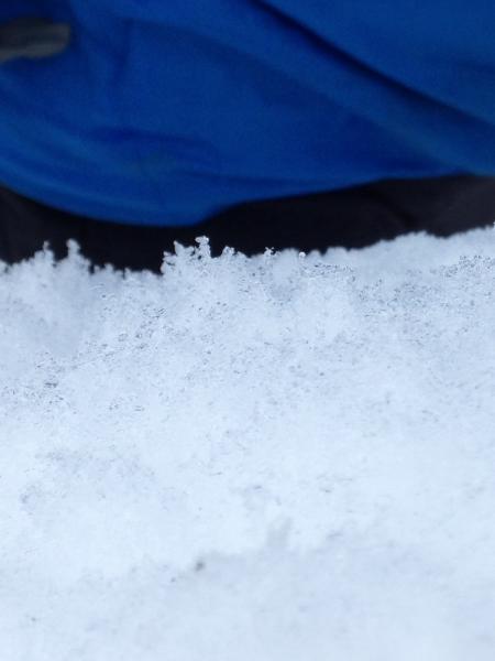
Facets and surface hoar under a thin wind slab.
Video from Alta Perimeter Mountain resorts are not open and have a backcountry snowpack - we see early season accidents every season. Please check in as different mountain resorts have different uphill policies. Some resorts are open to uphill traffic before they open, others not. Please obey all signs, and if you've got questions, stop in and talk to an employee. We're posting observations from the backcountry on a daily basis now. See or trigger an avalanche? Shooting cracks? Hear a collapse? It's simple. Go here to fill out an observation. |
| type | aspect/elevation | characteristics |
|---|

|
|
LIKELIHOOD
 LIKELY
UNLIKELY
SIZE
 LARGE
SMALL
TREND
 INCREASING DANGER
SAME
DECREASING DANGER
|
|
description
With such little snow, the primary danger is hitting rocks and stumps. |
 |
weather While a mid level, frontal boundary stalled to the north, the main trough is further south and will move through southern Utah today. As this trough moves east, a slightly unstable northwest flow will form over the Wasatch and deliver only a few inches of snow tonight. Dry conditions conditions are expected through the weekend. |
| general announcements Remember your information can save lives. If you see anything we should know about, please participate in the creation of our own community avalanche advisory by submitting snow and avalanche conditions. You can also call us at 801-524-5304, email by clicking HERE, or include #utavy in your tweet or Instagram. To get help in an emergency (to launch a rescue) in the Wasatch, call 911. Be prepared to give your GPS coordinates or the run name. Dispatchers have a copy of the Wasatch Backcountry Ski map. If you trigger an avalanche in the backcountry, but no one is hurt and you do not need assistance, please notify the nearest ski area dispatch to avoid a needless response by rescue teams. Thanks. Salt Lake and Park City – Alta Central (801-742-2033), Canyons Resort Dispatch (435-615-3322) Snowbasin Resort Dispatch (801-620-1017), Powder Mountain Dispatch (801-745-3772 x 123). Sundance Dispatch (801-223-4150) EMAIL ADVISORY If you would like to get the daily advisory by email you will need to subscribe here. DAWN PATROL Hotline updated daily by 5-530am - 888-999-4019 option 8. Twitter Updates for your mobile phone - DETAILS UDOT canyon closures: LINK TO UDOT, or on Twitter, follow @UDOTavy, @CanyonAlerts or @AltaCentral Utah Avalanche Center mobile app - Get your advisory on your iPhone along with great navigation and rescue tools. Wasatch Powderbird Guides Blog/Itinerary for the Day. Lost or Found something in the backcountry? - http://nolofo.com/ To those skinning uphill at resorts: it is your responsibility to know the resort policy on uphill travel. You can see the uphill travel policy for each resort here. IMPORTANT: Before skinning or hiking at a resort under new snow conditions, check in with Ski Patrol. Resorts can restrict or cut off access if incompatible with control and grooming operations. Benefit the Utah Avalanche Center when you shop from Backcountry.com or REI: Click this link for Backcountry.com or this link to REI, shop, and they will donate a percent of your purchase price to the UAC. Both offer free shipping (with some conditions) so this costs you nothing! Benefit the Utah Avalanche Center when you buy or sell on ebay - set the Utah Avalanche Center as a favorite non-profit in your ebay account here and click on ebay gives when you buy or sell. You can choose to have your seller fees donated to the UAC, which doesn't cost you a penny. This information does not apply to developed ski areas or highways where avalanche control is normally done. This advisory is from the U.S.D.A. Forest Service, which is solely responsible for its content. This advisory describes general avalanche conditions and local variations always exist. |