| Please join us at the 23rd annual Black Diamond Fall Fundraiser Party Thursday Sept 15. Tickets are on sale now here, at the Black Diamond store & at REI. Special bonus raffle for online ticket purchasers! |
| Please join us at the 23rd annual Black Diamond Fall Fundraiser Party Thursday Sept 15. Tickets are on sale now here, at the Black Diamond store & at REI. Special bonus raffle for online ticket purchasers! |
| Advisory: Salt Lake Area Mountains | Issued by Evelyn Lees for Sunday - November 1, 2015 - 5:49pm |
|---|

|
bottom line Winter is on the way, and we will issue intermittent avalanche forecasts this week as the upcoming storm dictates.
|
 |
special announcement A huge thanks to all who participated in USAW Saturday – to Craig Gordon and Paul Diegel for the organization, and to all the vendors, speakers, volunteers and those who came to listen, ask questions and make comments. |
 |
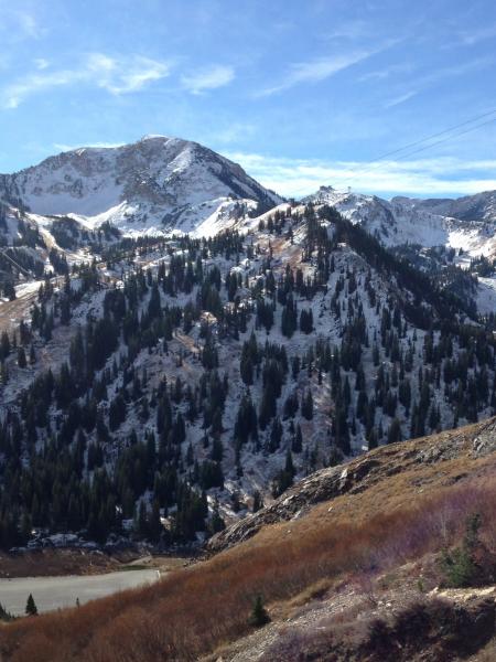
current conditions It was another warm, windy day in the mountains. Several inches of snow from the last storm remain on the cold, shady mid and upper elevation slopes, with the sunny slopes melted back to bare ground. The snow at the highest, northerly elevations did get a chance to start to facet, but another 24 hours of warmth, wind and clouds should slow and even reverse that process. And on many slopes, the snow is just patchy, and settled in among the rocks and vegetation. Still, it's worth taking a look at the old snow distribution ahead of this storm. Top photo: upper, northerly facing slopes in Little Cottonwood Bottom Photo : Northerly facing snow warm and moist enough to make a snowball.
|
 |
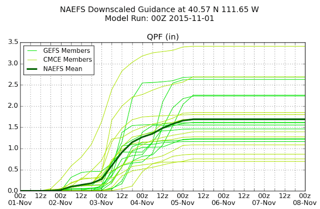
weather All eyes are on the weather forecast, with what could be the first significant storm of the year on tap to arrive this week. Very warm temperatures and increasingly strong southwesterly winds will continue tonight and Monday, with occasional rain showers possible. It looks like the best window for mountain snow will start Tuesday afternoon and continue through Wednesday night. No guesses on snow totals yet, but below is an interesting graph from Wasatch Weather Weenies Blog. Average seems to be about an inch and a half of water, so guessing a foot or more of snow? “The pattern remains quite chaotic and we're still seeing quite a bit of spread in the model forecasts. Our downscaled NAEFS product is showing anywhere from 0.7 to 3.5 inches of water amongst the various members at Alta Collins, for example”.
|