25th Annual Black Diamond Fall Fundraising Party
Thursday, September 13; 6:00-10:00 PM; Black Diamond Parking Lot
25th Annual Black Diamond Fall Fundraising Party
Thursday, September 13; 6:00-10:00 PM; Black Diamond Parking Lot
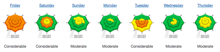
| Advisory: Provo Area Mountains | Issued by Greg Gagne for Friday - March 30, 2018 - 7:01am |
|---|

|
bottom line The current avalanche hazard is generally LOW with a Moderate hazard for wet loose avalanches on sunny aspects as the day warms. Risks in mountain travel are always present: don't let your guard down for pockets of recent wind-drifted snow at the mid and upper elevations. Although very unlikely, deep slab avalanches remain a concern in very isolated terrain such as thinner snowpack areas.
|
 |
special announcement The newest issue of the Powder Cloud, the newsletter of the Utah Avalanche Center, is hot off the digital presses. You can look at new and old issues of the Powder Cloud, other essays, and blogs in the menu above or click here.
The UAC Marketplace is still open. Our online marketplace still has deals on skis, packs, airbag packs, beacons, snowshoes, soft goods and much more. |
 |
current conditions Under partly cloudy skies and a setting full moon, 7 am temperatures in the Provo mountains are in the upper 20's through low 30's Fand winds are out of the west/southwest. At mid elevations winds are less than 10 mph with gusts in the teens, with gusts into the 20's mph at the upper elevations. Last Thursday's rain event left behind a slick 2-6" thick rain crust that is now covered with pockets of wind drifts, sastrugi, and even patches of soft-ish/dry snow. Winds on Wednesday and into Thursday morning created widespread wind-affected snow in exposed mid and upper elevation terrain, and clearing skies yesterday afternoon left behind sun and temperature crusts on south and west aspects, and all around the compass at lower elevations. That said, if you search you can still find dry, chalky snow on northerly aspects at the mid and upper elevations, such as what UAC pro observer, the intrepid Mark White, found yesterday in Red Pine Gulch in Little Cottonwood Canyon. Although Salt Lake-centric, our Week in Review summarizes weather and avalanche activity over the past week:
|
 |
recent activity No backcountry avalanche activity was reported from Thursday other than minor wet loose activity on steep solar aspects. |
| type | aspect/elevation | characteristics |
|---|

|
|
LIKELIHOOD
 LIKELY
UNLIKELY
SIZE
 LARGE
SMALL
TREND
 INCREASING DANGER
SAME
DECREASING DANGER
|
|
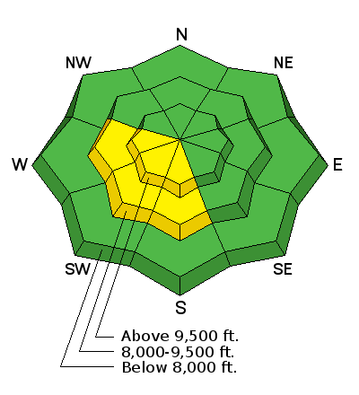
description
Warm overnight temperatures may soften the snow surface quickly today, and there is a possibility for loose wet avalanches on solar aspects at the mid and upper elevations. Clues such as wet rollerballs are a sign of instability. |
| type | aspect/elevation | characteristics |
|---|

|
|
LIKELIHOOD
 LIKELY
UNLIKELY
SIZE
 LARGE
SMALL
TREND
 INCREASING DANGER
SAME
DECREASING DANGER
|
|
description
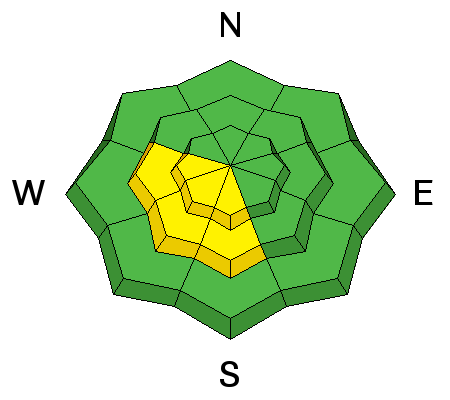
The avalanche hazard is generally Low and avalanches are unlikely. But travel in avalanche terrain is never a completely safe game, so watch for the following issues on isolated features: Wind Drifts - Yesterday my partner Bob Frey and I did our best to pry out drifts from Wednesday's winds (link to our observation), but we had no luck as the wind-drifted snow was unresponsive to ski cuts or other stability tests. However, there was a skier-triggered wind slab from Wednesday in the Salt Lake mountains, and a rogue wind drift at the mid and upper elevations may still be found that is sensitive to the weight of a rider. Persistent Deep Slab - For the first time since mid-December, we are dropping persistent slab/deep slab as an avalanche problem. This doesn't mean the issue has gone away. Rather, it is currently dormant and avalanching on these deeper layers is very unlikely. That is, dormant and unlikely until things change such as a substantial new load or rapid warming. The snowpack is especially weak in the Provo mountains, and buried persistent weak layers may become reactive more quickly than in the Salt Lake mountains once provoked. For the time being, last Thursday's rain event has created a strong bridge over these deeper weak layers, and they continue to adjust and strengthen. UAC director Mark Staples provides an excellent video summary of the current state of the snowpack: And finally, the 2-6" thick impenetrable 3/22 rain crust may create slide-for-life conditions on steep aspects. Consider taking ski crampons, ice axe, and/or whippet if you choose to travel in steeper terrain. Otherwise we have a generally stable, modestly-deep snowpack providing excellent travel conditions for touring in the alpine zones. |
 |
weather For today we'll have partly cloudy skies with low elevations rising into the low 50's F, and into the 30's and 40's in the upper and mid elevations respectively. Winds will be out of the west/southwest, averaging in the teens at mid elevations, and in the 20's mph at upper elevations (into the 30's mph as you approach 11,000'). Winds are forecasted to increase as the day progresses, especially into the overnight hours. A weak system moves in on Saturday with increasing clouds and warmer temperatures, but unfortunately with no accompanying precipitation. Although we have no significant storms forecasted over the next 7 days, the models are also not suggesting winter is over. |
| general announcements CLICK HERE FOR MORE GENERAL INFO AND FAQ The UAC has new support programs with Outdoor Research and Darn Tough. Support the UAC through your daily shopping. When you shop at Smith's, or online at Outdoor Research, REI, Backcountry.com, Darn Tough, Patagonia, NRS, Amazon, eBay a portion of your purchase will be donated to the FUAC. See our Donate Page for more details on how you can support the UAC when you shop. Benefit the Utah Avalanche Center when you buy or sell on eBay - set the Utah Avalanche Center as a favorite non-profit in your eBay account here and click on eBay gives when you buy or sell. You can choose to have your seller fees donated to the UAC, which doesn't cost you a penny This information does not apply to developed ski areas or highways where avalanche control is normally done. This advisory is from the U.S.D.A. Forest Service, which is solely responsible for its content. This advisory describes general avalanche conditions and local variations always occur. |